
The Time Gap Island: Where You Can See Into Tomorrow
Between Russia and America, a 3.5 km stretch across the Diomede Islands lets you travel 21 hours into the future—without a time machine.

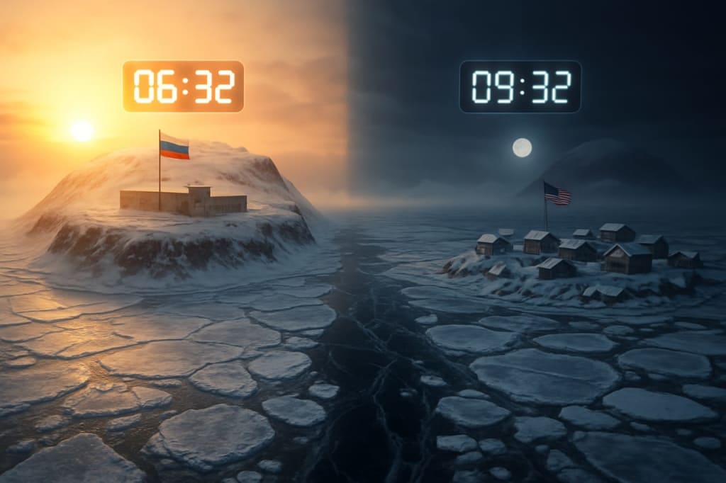
Between America and Russia, in the frozen waters of the world’s two great oceans—the Pacific Ocean and the Arctic Ocean—stand two remarkable islands known as the Diomede Islands. These islands are so close that on a clear day you can see from one to the other without binoculars. The larger island to the west is called Big Diomede, and it is controlled by Russia. The smaller island to the east is Little Diomede, which belongs to the United States of America.
The most fascinating aspect of these islands is that even though they are separated by only about 3.5 kilometers (approximately 2.2 miles), there is an almost 21-hour time difference between them. This means that if it is 3 p.m. on Monday afternoon on Little Diomede (the American island), it will already be 12 p.m. on Tuesday on Big Diomede (the Russian island). In other words, crossing these 3.5 kilometers by boat or over the ice is like traveling into the future or going back in time.
During some parts of the year, this difference becomes even more visually striking. On one side, you can see the darkness of night and a bright moon shining over the ice, while on the other side, the golden light of sunrise is illuminating the horizon. Very few places on Earth offer this surreal experience of simultaneously witnessing yesterday and today with your own eyes.
The reason behind this phenomenon lies in an imaginary system of lines drawn on Earth called meridians. These lines run vertically from the North Pole to the South Pole and are used to measure longitude. Because the Earth is roughly spherical, it can be divided into 360 degrees around its circumference.
To establish a reference, one of these lines passing through Greenwich, England, was designated as the Prime Meridian, marked as 0° longitude. The time at this line is called Greenwich Mean Time (GMT). This became the baseline for measuring time zones across the world.
As you move eastward from the Prime Meridian, every 15 degrees of longitude equals a difference of +1 hour compared to GMT. So, for example, a location at 15° east is GMT+1, 30° east is GMT+2, and so on. Conversely, moving westward from Greenwich means subtracting time: every 15 degrees west equals GMT−1, GMT−2, etc.
When you follow this pattern all the way around the globe, you eventually arrive at 180° longitude on the opposite side of the Earth. Here, the time difference accumulates to a full 24 hours. This line is called the International Date Line, and it passes mostly through the middle of the Pacific Ocean.
The International Date Line is what creates the time gap between Big Diomede and Little Diomede. Big Diomede lies just to the west of this line, while Little Diomede lies just to the east. Therefore, the Russian island is almost a day ahead of the American island. It’s often said that you can “look into tomorrow” simply by gazing across the water.
Interestingly, the International Date Line does not perfectly follow the 180° meridian in a straight line. If it did, it would slice many countries and islands into different calendar days. To avoid this confusion, the Date Line zig-zags around certain territories so that nations can maintain a unified date and time across their lands. For example, Kiribati, a Pacific island nation, decided in 1995 to shift the Date Line eastward so that all of its islands would share the same day.
In Pakistan’s case, the country is located between approximately 60°E and 77°E longitude, so there are about 18 meridians passing through Pakistan’s territory. Yet, Pakistan has standardized its time to GMT+5, based on the 75th meridian, to keep a uniform national clock.
This standardized system of time zones, meridians, and the Date Line is what allows global communication, travel schedules, and economic activities to function smoothly. Imagine the chaos if every city in the world chose its own arbitrary time without reference to these coordinates!
The Diomede Islands remain a powerful reminder of how arbitrary human-made time conventions can feel when you stand between them. During winter, the sea between them freezes solid, forming an icy bridge. In the past, native Inuit communities would cross this ice to visit family. Today, due to international borders, the islands are heavily restricted, and such crossings are prohibited without special permissions.
If you ever visit Little Diomede (which has a small village inhabited by about 80 people), you can look across to Big Diomede, uninhabited except for a Russian border guard post, and reflect on how merely a few kilometers of frozen water separates not just two countries but also two different calendar days.
In essence, the Diomede Islands are one of Earth’s most fascinating examples of how geography, politics, and time converge—where the idea of today and tomorrow becomes tangible in a way that no clock or calendar can fully capture.
About the Creator
3 Historical Events That Were Ruined by One Incredibly Small Detail
History is shaped by big ideas, brave leaders, and sweeping movements—but sometimes, the tiniest, most overlooked detail changes everything. A forgotten note, a misheard order, or even a misaligned boot can turn a decisive moment into chaos. These micro-errors often seem trivial at the time, but their ripple effects can alter the course of wars, empires, and even the future of entire nations.
By Enoch Sagini2 days ago in History
How Early Aircraft Failures Created Modern Flight Safety
When we look at modern aviation today with its redundant systems, strict regulations, and impressive safety record it’s easy to forget how fragile flight once was. Early aviation wasn’t built on confidence or certainty. It was built on risk. Every successful flight was surrounded by countless failures, and every crash carried lessons that would quietly reshape the future of air travel.
By Beckett Dowhana day ago in History


Comments
There are no comments for this story
Be the first to respond and start the conversation.