
🗺️ Piri Reis Map – A 1513 Ottoman map that accurately shows parts of the Americas and Antarctica… centuries before they were "discovered
One of history’s most fascinating cartographic artifacts

The Piri Reis Map of 1513, crafted on a handsome piece of gazelle parchment approximately 87 by 63 centimeters, is one of the world’s most captivating cartographic artifacts. Rediscovered in 1929 in Istanbul’s Topkapi Palace, it represents the western third of an otherwise lost masterpiece, gifted by Piri Reis—an Ottoman naval officer, geographer, and cartographer—to Sultan Selim I after the conquest of Egypt in 1517. This single map fragment encapsulates an astonishing blend of ancient classical knowledge, contemporary seafaring intelligence, and a global vision that was well ahead of its time.

Piri Reis began life in Gallipoli around 1465, under the mentorship of his famed uncle Kemal Reis, a naval commander who instilled in him both maritime skill and exposure to Mediterranean and Atlantic trade routes. He inherited his uncle’s treasure trove of logbooks, portolan charts, and sea charts—tools that would form the backbone of his early world map, completed in March–April 1513 and clearly dated within the map’s colophon.
In Piri’s own marginalia, penned in Ottoman Turkish, he meticulously lists his map’s sources: “twenty charts and mappae mundi,” “eight Jaferiyas” (Ptolemaic-geographical maps), a detailed “Arabic map of India,” four Portuguese regional charts, and famously, “a map drawn by Columbus” illustrating his latest discoveries. Such scholarly transparency is unprecedented in premodern cartography—it shows remarkable confidence and a global fusion of geographies linking Mediterranean, Portuguese, Arabic, and New World sources.
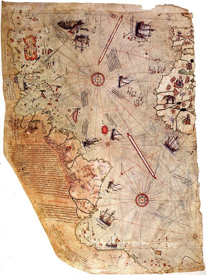
Cartographically, the map is a portolan-style chart, featuring rhumb-line networks radiating from compass roses—essential tools for navigators using dead reckoning. Yet it also includes early signs of latitude measurement, especially along Brazil’s coast where crude degree markers hint at a hybrid of portolan and proto-Mercator projection. Despite its succinct size, Piri’s chart renders the coastlines of Europe—Spain, Portugal, the Straits of Gibraltar—accurately; North and West Africa, including Cape Verde; and most astonishingly, the Brazilian coastline near Cabo Frio and Rio de Janeiro with unusual precision for its time, influenced largely by newly sourced Portuguese information.

Perhaps the most debated element lies at its southern extremity—a sweeping, curved landmass sometimes conflated with the mythical Terra Australis Incognita, and in fringe interpretations even thought to show an ice-free Antarctic coast based on comparisons with mid-20th-century seismic profiles. However, serious scholarly scrutiny points to a more prosaic origin: a distorted depiction of South American Patagonia, extended south and east to fill parchment space, described by Piri himself as "warm, with snakes"—a climate far removed from Antarctic conditions.
Critics emphasize that Chilean, Argentine, or Antarctic coastlines are portrayed hundreds of kilometers north of their actual locations, lacking any delineation of the Drake Passage. Historic patterns of Portuguese cartography viewed Brazil’s coast as wrapping southeastward, which aligns with Piri’s map—confirming convergence with period knowledge rather than any secret ancient surveying.
Beyond geography, the map exudes cultural texture: miniature Islamic art, sea monsters at the map’s edges, notations mentioning parrots, dyes, and mythical Antiochian islands—all hinting at Piri’s broader ethnographic awareness and fusion of narrative with navigational precision.

Following his 1513 map, Piri produced his influential Kitab-ı Bahriye (Book of Navigation) in 1521, later expanded in 1526 under Grand Vizier Ibrahim Pasha. Across 130 to 210 chapters and over 200 large-scale charts, it became a Mediterranean navigation cornerstone—integrating textual sailing directions with visual maps, detailing coastal hazards, freshwater sources, tides, fortresses, and port systems. Admirers often deem it the most detailed 16th-century portolan atlas—melding practicality, artistry, and intellectual breadth.

Piri's later life saw him rise to Admiral of the Ottoman fleet in the Indian Ocean, capturing strategic ports such as Aden, Muscat, and Hormuz before a controversial retreat from Basra led to his execution in 1553–54—the end of a life devoted to charting oceans and connecting continents.
Today, the Piri Reis Map is a UNESCO Memory of the World icon and remains a focal point of mainstream cartographic scholarship and fringe speculation alike. While some romanticize it as proof of lost civilizations or Atlantean maps, the academic consensus is clear: the Piri Reis Map reflects documented cartographic craftsmanship, blending diverse sources into a coherent, culturally rich, navigationally effective tool that set new benchmarks in 16th-century global geography.
After crafting the remarkable 1513 map that showcased his ability to synthesize diverse cartographic knowledge, Piri Reis’s contributions to navigation and geography extended even further through his magnum opus, the **Kitab-ı Bahriye** (The Book of Navigation). This encyclopedic work was groundbreaking not just for its extensive detail but also for its innovative fusion of text and visuals—something that was rare in maritime literature of the time. Over **130 to 210 chapters**, depending on editions, the Kitab-ı Bahriye provided detailed descriptions of coasts, harbors, islands, currents, wind patterns, and navigational hazards primarily in the Mediterranean Sea, a critical theater of naval activity for the Ottoman Empire and other maritime powers.
The charts within Kitab-ı Bahriye were crafted with artistic flair but served a practical purpose. They included compass roses, rhumb lines (lines of constant compass direction), and coastal profiles that helped sailors recognize landforms from the sea. Piri's descriptions combined the latest Ottoman intelligence with information inherited from earlier Mediterranean sailors, Arab geographers, and even European explorers. This made the Kitab-ı Bahriye not only a navigational guide but also a comprehensive record of maritime knowledge and geography of the early 16th century.
Moreover, Piri Reis incorporated ethnographic details, economic notes on trade goods, cultural observations, and warnings about pirate-infested waters. This enriched the book beyond a mere sea atlas into a broader cultural document reflecting the geopolitical importance of the Mediterranean. The detailed recording of ports — including those in Italy, Greece, North Africa, and the Levant — was vital for Ottoman expansion, trade, and military campaigns. His detailed attention to small details like anchorage depths, available supplies, and fortifications demonstrated a rare combination of cartographer, navigator, and strategist.

The Kitab-ı Bahriye's impact extended far beyond its own era. Ottoman sailors and admirals relied on it for centuries, and it was one of the first to successfully integrate text with precise cartographic visuals in a way that could be used practically at sea. Some modern scholars credit Piri Reis’s work as a bridge between medieval portolan charts, which were primarily visual, and the more scientifically rigorous maps that would follow in the Age of Enlightenment. His blend of classical sources like Ptolemy with new information from the Age of Discovery illustrates how knowledge evolved through cross-cultural exchanges during the Renaissance.
Beyond his books and maps, Piri Reis was an active naval commander. His leadership in the Ottoman fleet helped secure vital maritime routes in the Red Sea, Indian Ocean, and Persian Gulf, protecting trade routes against Portuguese incursions and expanding Ottoman influence in strategically important areas. His campaigns in Yemen, Aden, Hormuz, and the Arabian coast consolidated Ottoman naval power during a time when European colonial expansion threatened to shift global trade networks. This made Piri a key figure in the naval history of the 16th century and a symbol of the Ottoman Empire’s maritime ambitions.
However, his career was not without controversy. In 1553, Piri Reis faced accusations of withdrawing prematurely from a naval battle in Basra, which led to his imprisonment and eventual execution. Despite this tragic end, his legacy was secured by his maps and writings, which survived as invaluable historical documents illustrating the early globalized knowledge networks of his time.
The Piri Reis Map remains an object of intense fascination for historians, cartographers, and enthusiasts worldwide. While some fringe theories have sensationalized it as proof of ancient lost civilizations or advanced prehistoric knowledge, rigorous scholarly research confirms that it is a product of **careful compilation, synthesis, and skilled artistry** reflecting 16th-century geographical understanding. The map’s significance lies in its **bridging of classical traditions with contemporary discoveries**, acting as a tangible symbol of the expanding horizons during the dawn of global exploration.

In sum, Piri Reis and his map represent a remarkable chapter in the history of cartography and maritime exploration. His work embodies the spirit of curiosity, cross-cultural knowledge exchange, and the relentless human pursuit of understanding the world’s geography — a pursuit that continues to shape how we see our planet today.
About the Creator
Kek Viktor
I like the metal music I like the good food and the history...
Keep reading
More stories from Kek Viktor and writers in History and other communities.
⛏️Venetian Glass Beads found in Alaska - Amazing archeological findings
Venetian glassmaking reached its zenith during the late Middle Ages and Renaissance, with the city of Venice becoming the epicenter of fine glass production. The island of Murano, in particular, became renowned worldwide for its advanced techniques, including cristallo (crystal-clear glass), millefiori (multicolored patterns), and elaborate formings.
By Kek Viktor8 months ago in History
Nanchang: A Modern Symbol of China’s Naval Power
In recent years, the world has closely watched the rapid modernization of the Chinese People’s Liberation Army Navy (PLA Navy). One of the most important symbols of this transformation is the Nanchang (Hull 101), China’s first Type 055 guided-missile destroyer. Commissioned on 12 January 2020, Nanchang represents a major leap in naval technology and capability. As it completes six years of active service, the ship stands as a clear example of how China’s navy has moved into a new era of advanced maritime power.
By sehzeen fatima7 days ago in History
Where the Pulse Ends
© 2026 Sai Marie Johnson The humidity in the city didn’t just hang; it leaned. It was a thick, stagnant soup of diesel exhaust, ozone, and the metallic tang of blood that drifted from the "Compliance Zones." Joe sat in his rusted sedan, his hands resting loosely on the steering wheel. He wasn't gripping it. He wasn't angry. Anger was a chemical spike, a biological inefficiency. Joe was simply... focused.
By Sai Marie Johnson4 days ago in History


Comments
There are no comments for this story
Be the first to respond and start the conversation.