
Most global maps make Greenland appear larger than it is in reality.
The size of Greenland on maps

According to a global investigation, people's perceptions of major nations are systematically changed by the type of world map they view, making Greenland one of the most overstated locations on the planet.
This skewed perception of scale permeates discussions about the Arctic, influencing which areas are portrayed as strategically central, dominant, or remote. The proof comes from a global online survey that asked regular map users to rate the sizes of various nations on well-known global maps.
Geographer Lieselot Lapon of Ghent University (UGent) directly tracked how those assessments changed with the map in front of them by recording the answers of over 130,000 volunteers.
High-latitude locations were consistently assessed as being far larger than they actually are, and this pattern persisted across age groups and geographical areas. The findings indicate which particular map design decisions require further investigation.
Why do certain maps extend across nations?
A map projection, which is a set of guidelines for depicting Earth on a flat surface, is used in all flat globe maps.
According to the U.S. Geological Survey (USGS), "no flat map can compete with a globe in accurately depicting the surface of the entire Earth, so every flat map misrepresents the surface of the Earth in some way."
Areas are stretched farther and farther as you approach the poles on the Mercator projection, a navigation map that accurately depicts directions.
Greenland still appears huge next to Africa because of the compromise made when Gerardus Mercator built it in 1569 for sailors.
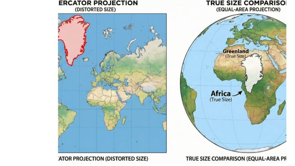
Africa versus Greenland
Once the actual area figures are in, the size uncertainty stops because Greenland and Africa are not even close to being equal.
The land area of Greenland is around 836,000 square miles, which is a significant amount to put on a single island. The total land area of Africa is approximately 14 times bigger, at 11.7 million square miles.
When readers notice that disparity, Greenland's dominance on maps appears to be more of a design decision than a geographical feature.
Africa and Greenland seem to be about the same size on most maps. Africa is actually 14 times bigger than Greenland. Africa is around 11.7 million square miles, whereas Greenland is approximately 822,000 square miles.
After testing the cognitive map—the rudimentary mental map—researchers looked for areas where it faltered. Because the brain interprets the sketched forms as actual proportions, repeated exposure to a single projection can train that mental image.
The findings show that accuracy varies with map projection, but not to the degree that a person's global-scale cognitive map reflects a certain map projection, according to Lapon.
Small regions were more frequently inflated in the UGent dataset, and the researchers was unable to discover conclusive evidence of any Mercator effect.
Online map distortions
Because fluid scrolling and zooming function best when the arithmetic remains straightforward, online maps maintained the distortion.
The majority of services used Web Mercator, a computer-optimized version of Mercator that makes tile fitting simple. Because a user can drag from Paris to Nuuk and blindly believe the scale, the same choice can skew comparisons.
In 2018, Google Maps altered its desktop world view to display the Earth as a globe, however Web Mercator remained available on phones.
land with minimal population
Towns and small communities cling to the coast since the interior of Greenland remains frozen solid. 56,609 people called the island home as of January 2023, with many residing in the capital, Nuuk, or neighbouring towns.
Among Greenland's recognised natural resources, official summaries also mentioned rare earth metals, which are components used in electronics and magnets. Even before politics enters the picture, Greenland's vast land area and small population make it simple to exaggerate its significance on maps.
The strategic location of Greenland
Because Greenland is situated along Arctic routes connecting continents, map illusions clash with actual strategy as nations look north. Pituffik Space Base in northwest Greenland is operated by the United States and serves as a space surveillance and missile warning facility.
Although Denmark continues to provide significant money, Greenland still controls the majority of local affairs, which might make outside proposals seem alluring. The island's location and defences keep it in focus, even though a smaller Greenland may defuse some heated debates.
Global dangers are increased by ice melt.
Greenland's size on a map now corresponds to actual water levels on far-off coasts, which increases urgency due to climate change. NASA discovered that between 1992 and 2018, the Greenland Ice Sheet lost 3.8 trillion tonnes of ice.
NASA predicted that the global sea level would increase by an additional 3 to 5 inches by 2100 as a result of that melt water. Although those figures will continue to be updated by new NASA estimations, map distortions may obscure the actual scope of a changing Greenland.
Fixing the size of Greenland on maps
When comparison is important, schools can choose maps that depict the actual location, since cartographers have long provided options.
To ensure that countries maintain their correct size even when shapes bend, some cartographers opt for an equal-area projection, which maintains regions proportionate.
Researchers at UGent discovered that individuals who chose maps with less area distortion tended to make more accurate estimates than those who used Mercator. Since no projection can be completely accurate, readers should view any map as a tool designed for a certain purpose.
Greenland's value is not diminished by adjusting its apparent size. The island still has significant weight due to its resources, strategic defences, and fast melting ice. More precise maps keep Arctic arguments on topic and help bring those conversations back to reality.
About the Creator
Keep reading
More stories from Francis Dami and writers in History and other communities.
Mummy CT scans provide fascinating insights on ancient Egyptian life.
The purpose of CT scanners is to diagnose the living by precisely mapping concealed tumours, obstructed arteries, and fractured bones. Restoring individual stories that have been silent for thousands of years is an unanticipated outcome of applying the same technology to the ancient past.
By Francis Damia day ago in History
A Day That Broke Time
A Day That Broke Time The morning had started like any other in the sleepy town of Rivermist. Sunlight spilled lazily across cobblestone streets, and the air smelled of dew and wet earth. People went about their routines—bakers kneading dough, children chasing each other to school, and old men sipping tea on wooden benches. But something in the air that day felt… off, though no one could have said exactly what.
By Samaan Ahmada day ago in History
Should We Not Try to Get Too Political?
Here's something you often hear people say, "I try not to get too political." I understand the sentiment and I sympathize with it... while at the same exact time, I completely disagree with the notion. Whether it's referring to social media or wherever, it's kind of unavoidable. You can attempt to sidestep it, not engage, leave the less important things for actual politicians to discuss... you can want it to not take over your life, your conversations, your relationships, and that makes perfect sense.
By Stephen Kramer Avitabile6 days ago in Writers


Comments
There are no comments for this story
Be the first to respond and start the conversation.