
Tropical System Invest 97L Could Become Hurricane Helene, Threatens Florida Later This Week
"Florida Braces for Possible Hurricane as Tropical System Strengthens in the Gulf"
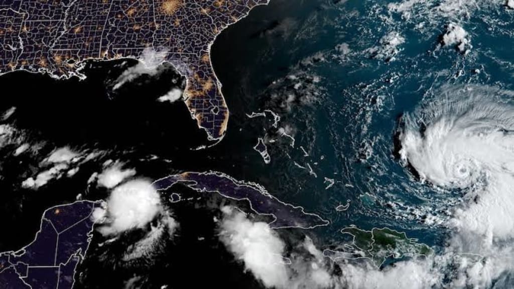
Florida residents are keeping a close eye on a tropical disturbance known as Invest 97L, which could soon develop into a hurricane. According to the National Hurricane Center (NHC), the system is showing strong signs of intensification and could impact parts of Florida later this week. As of Monday morning, the NHC has given the system a 70 percent chance of development within the next two days and a 90 percent chance within the next seven days. If it strengthens into a tropical storm, it will be named Helene.
Growing Chances of Development
The NHC’s increasing confidence in the storm’s development has raised concerns among meteorologists and residents alike. The warm waters of the Yucatán Channel, which the system is currently moving through, are ideal conditions for the storm to strengthen. This region is known for deep, warm water, which provides the energy that hurricanes need to grow in intensity.
FOX 13 meteorologist Dave Osterberg says that while the exact path of the storm is still uncertain, most forecast models show Invest 97L becoming a hurricane in the coming days. "We are going to get impacts," Osterberg warned. He explained that even though the system’s path is not set in stone, it will likely impact Florida, particularly the Panhandle or Big Bend area, as early as Thursday.
Possible Landfall and Timing
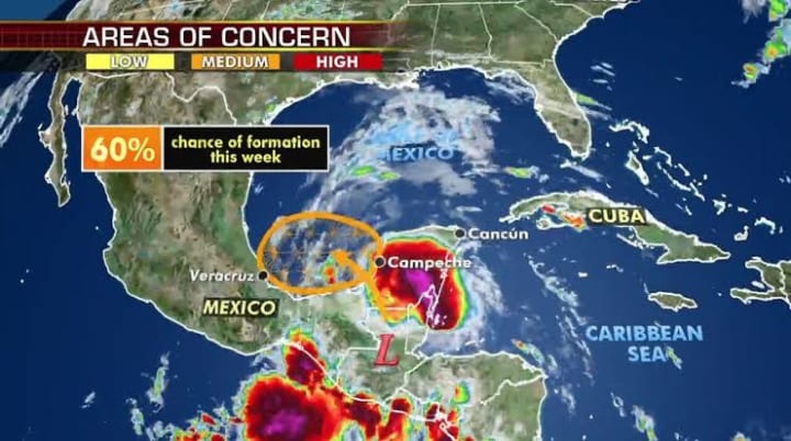
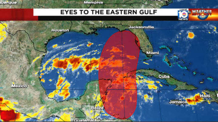
Currently, the models are showing the storm potentially making landfall in the Florida Panhandle or Big Bend area. However, a shift of just 50 miles in either direction could greatly change the forecast, meaning different parts of Florida may experience varying levels of impact. Osterberg emphasized that Floridians should prepare for the possibility of strong winds, heavy rainfall, and storm surge, especially on Wednesday and Thursday.
“We’ll start to feel the effects late Wednesday, and by Thursday, most of the day will be impacted,” Osterberg noted. These early impacts may include outer rain bands, gusty winds, and higher-than-normal tides along Florida’s Gulf Coast.
Uncertainty in the Storm’s Track
While Invest 97L is expected to strengthen, the uncertainty surrounding its track means it’s difficult to predict exactly where it will make landfall or which areas will see the most significant effects. Over the next 24 to 36 hours, as the system continues to develop and move, forecasters expect to get a clearer picture of its exact path.
"The models are still somewhat divided," Osterberg said, referring to the different possibilities for where the storm could go. "Some models show it taking a more westerly path, which would put it closer to the Panhandle, while others show it shifting east, which could bring impacts further down the Gulf Coast, including the Tampa Bay area."
This slight difference in the storm's direction could be crucial in determining how much rain, wind, and storm surge each area might experience. For now, meteorologists are advising people along the Gulf Coast to stay informed and prepared for the storm’s potential arrival.
Preparing for Possible Impacts
While the forecast models continue to shift, it’s important for Floridians, especially those in the Panhandle and Big Bend areas, to be ready for any potential storm impacts. The hurricane season is far from over, and storms like Invest 97L can develop quickly, leaving little time for preparation.
In light of the system’s increasing chances of strengthening, Florida officials are urging residents to review their emergency plans, gather supplies, and keep a close eye on updates from the National Hurricane Center. "We are asking people to make sure they have a plan in place," said local emergency management officials. "This includes stocking up on essentials like water, non-perishable food, and batteries, and being aware of any evacuation orders that might be issued later in the week."
Residents should also be prepared for the possibility of power outages, flooding, and other disruptions. Even if the storm doesn’t directly hit a particular area, the outer bands of a hurricane can bring heavy rains and strong winds to areas hundreds of miles from the center of the storm.
Staying Informed
As Invest 97L continues to develop, the next 24 to 36 hours will be crucial in determining where the storm is headed and how strong it will become. Meteorologists will be closely monitoring the system, and updates from the National Hurricane Center will provide more details as the storm nears Florida.
For those living in Florida, especially in the areas most likely to be affected, staying informed is key. Monitoring local weather reports, following the National Hurricane Center's updates, and heeding any warnings or advisories issued by state and local officials can help ensure that residents are prepared for whatever the storm may bring.
In conclusion, while the path and strength of Invest 97L remain uncertain, its chances of developing into Hurricane Helene are growing. Florida could begin to feel the storm’s effects as early as Wednesday, with potential landfall expected by Thursday. Whether the storm hits the Panhandle, Big Bend, or another part of Florida, residents should be ready for possible impacts and stay tuned for more updates as the storm progresses.
About the Creator
Inflation Remained at 2.7% in December: High Prices Continue to Weigh on Many Americans
As Americans rang in the new year, many were relieved to see that inflation in December held steady at 2.7%, according to the latest reports. On the surface, this might seem like good news — a signal that runaway price growth is slowing. But for countless households across the country, the reality is more complicated: high prices continue to strain budgets, affecting everything from groceries to gas, rent, and beyond. The Numbers Behind the Headlines December’s 2.7% inflation rate, measured year-over-year, shows no significant change from November. This is a continuation of the trend economists have watched closely throughout 2025: after a period of intense price spikes, inflation appears to be moderating but remaining stubbornly above pre-pandemic norms. Key areas contributing to this steady inflation include: Food prices, particularly meat, dairy, and fresh produce, which have remained elevated due to supply chain challenges and global agricultural pressures. Housing costs, including rents and home prices, which continue to rise in many urban and suburban markets. Energy prices, especially gasoline and home heating, which fluctuate seasonally but have not dropped enough to ease household pressure. While 2.7% may seem manageable compared to the double-digit spikes of 2021–2022, it still outpaces wage growth for millions of Americans, meaning that in real terms, many are experiencing reduced purchasing power. How Inflation Affects Everyday Americans For many families, the impact of steady inflation is tangible. Consider this: a household spending $500 a month on groceries in 2025 might now be paying over $535 for the same items. Gasoline, which has seen seasonal swings, can quickly add dozens of dollars to monthly commuting costs. Rent, historically the largest expense for most households, has grown faster than wages in many cities. A steady 2.7% inflation rate means renters face incremental increases in living costs every month, often outpacing salary adjustments. Even seemingly small price increases ripple across budgets. Families may delay purchases, cut discretionary spending, or tap savings, which in turn affects broader consumer demand — a key driver of economic growth. The Role of the Federal Reserve and Economic Policy Inflation is not just about prices at the grocery store — it’s also shaped by monetary policy, interest rates, and government action. Throughout 2025, the Federal Reserve maintained a cautious approach, keeping interest rates relatively high to control inflation without triggering a recession. The Fed’s actions aim to balance: Slowing price growth to protect consumers’ purchasing power Avoiding a sharp economic downturn that could result from overly aggressive rate hikes Despite these efforts, economists warn that inflation’s persistence at 2.7% suggests structural pressures in the economy. Global supply chain disruptions, rising energy costs, and ongoing demand for goods and services continue to exert upward pressure on prices, making it harder for policy alone to bring relief. Inflation and Wage Growth: A Delicate Balance One of the most concerning aspects of steady inflation is its relationship with wages. For workers whose salaries haven’t kept pace with rising costs, inflation effectively reduces real income. Some sectors, like technology and healthcare, have seen modest wage gains, but many service industries — retail, hospitality, and small businesses — continue to struggle. Employees in these fields often find that even small price increases can significantly affect their quality of life, from grocery shopping to transportation and childcare expenses. What This Means for the Economy Steady inflation at 2.7% has several implications for the broader economy: Consumer Spending: When households feel the pinch, discretionary spending declines, which can slow economic growth. Investment Decisions: Businesses facing higher input costs may delay expansion or hiring, affecting job markets. Housing Market Dynamics: Rising rent and home prices continue to challenge affordability, influencing both buyers and renters. Financial Planning: Americans are increasingly turning to budgeting strategies, high-yield savings, or side income to offset higher costs. Economists stress that while inflation at this level is not catastrophic, it remains a long-term concern, especially if wages fail to keep up with price growth. Strategies for Coping with Persistent Inflation For households navigating these pressures, there are several approaches: Budget adjustments: Tracking expenses and prioritizing essential costs can help manage monthly finances. Smart shopping: Using discounts, bulk purchasing, and price comparison can reduce grocery and household costs. Energy efficiency: Lowering utility bills through energy-saving practices mitigates rising energy prices. Financial literacy: Investments, savings, and debt management become even more crucial in times of persistent inflation. While these steps cannot eliminate inflation’s impact, they provide tangible ways for Americans to protect their finances. Looking Ahead Economists predict that inflation in 2026 may continue to hover around 2–3%, barring unexpected shocks such as global conflicts, energy crises, or supply chain disruptions. While not extreme, this range continues to influence household budgets, corporate planning, and government policy decisions. For many Americans, the lesson is clear: even modest inflation can weigh heavily on day-to-day life. Staying informed, adjusting financial habits, and understanding the economic landscape remain essential for navigating a world where prices are higher than before. Steady inflation at 2.7% is a reminder that economic stability is fragile. While the numbers suggest moderation, the lived experience of millions of Americans shows that high prices are far from over, influencing decisions from grocery shopping to career planning. As the new year unfolds, households, businesses, and policymakers alike must grapple with the realities of an economy where every percentage point matters.
By Muhammad Hassan6 days ago in Earth
UAE Enters Al Shabt: Brace for Winter’s Coldest Days
The United Arab Emirates is set to experience one of the harshest winter spells in recent memory as the country enters Al Shabt, a period traditionally associated with extreme cold. Residents across the emirates are being urged to prepare for temperatures that are expected to drop well below seasonal averages, with potential disruptions to daily life, travel, and energy consumption. Meteorologists have warned that Al Shabt, historically marked by icy winds and sudden temperature dips, will this year be particularly severe due to a combination of regional weather patterns and shifting global climatic trends. Forecasters predict nighttime temperatures in some areas could drop to as low as 8–10°C, a significant decline for a country more accustomed to mild winters. Coastal regions may experience slightly warmer conditions, but the cold will be intensified by strong northern winds sweeping across the Arabian Peninsula. Understanding Al Shabt Al Shabt, which translates to “the coldest part of winter,” is a term deeply embedded in Gulf traditions. Historically, Bedouins and farmers used the period to plan agricultural activities, livestock care, and resource management. Today, while modern infrastructure and urban planning mitigate some effects of the cold, the cultural significance remains, and residents are reminded of its intensity through historical observations and local weather lore. “Al Shabt is more than a cultural marker—it’s a meteorological reality,” said Dr. Aisha Al Mansoori, a senior climatologist at the UAE National Center for Meteorology. “We are observing patterns that suggest this Al Shabt could be colder than usual. Residents should take precautions, especially in northern and inland regions where the temperature drop will be most pronounced.” Preparing for the Cold Authorities across the UAE are taking proactive measures to help residents and businesses prepare for the upcoming cold spell. The Ministry of Interior has issued advisories for motorists to check vehicle heating systems and tire conditions, while electricity and water authorities are ensuring that energy grids are ready for increased demand. Hospitals and emergency services have also been put on alert to handle potential cold-related health incidents. Schools and universities are expected to remain open, but parents are being advised to dress children in warm layers and limit outdoor exposure, especially during early morning and late evening hours. Workplaces are encouraged to implement flexible schedules to reduce the risks associated with commuting during frigid mornings. Travel and Transportation Challenges The UAE’s extensive road network and urban infrastructure may face some challenges during Al Shabt. While snow is highly unlikely, fog formation during the early morning hours could reduce visibility, leading to potential travel disruptions. Aviation authorities are coordinating with meteorologists to monitor conditions at major airports, ensuring that flights remain on schedule while prioritizing passenger safety. “Drivers should exercise caution and plan extra time for their journeys,” said Hamad Al Suwaidi, a senior official at the Roads and Transport Authority. “Even a minor dip in temperature can create slick roads in certain areas, and we advise everyone to remain vigilant and adhere to safety guidelines.” Impact on Daily Life Beyond transportation, the cold weather is expected to affect outdoor events, construction projects, and energy consumption. Many outdoor workers may need additional protective clothing, while households will see a surge in electricity usage for heating. Retailers and service providers are preparing for increased demand for warm clothing, heaters, and other winter essentials. Health experts emphasize the need for precautions, particularly among vulnerable populations such as the elderly, children, and individuals with preexisting conditions. “Cold weather can exacerbate respiratory illnesses and cardiovascular problems,” said Dr. Mohammed Al Hammadi, a public health specialist. “Hydration, proper clothing, and staying indoors during the coldest hours are key measures to minimize health risks.” Looking Ahead While Al Shabt is expected to last for several days, meteorologists suggest that the period of extreme cold will gradually ease as the region transitions toward milder winter conditions. Nevertheless, residents are advised to remain prepared and informed, as sudden weather shifts are common in the Gulf. “The key to navigating Al Shabt is awareness and readiness,” Dr. Al Mansoori concluded. “The cold may be intense, but with proper precautions and respect for the weather, residents can stay safe and even enjoy the unique aspects of this traditional winter period.” In the coming days, the UAE will experience an unusual contrast—desert landscapes typically associated with warmth will be gripped by biting cold, reminding residents of the country’s diverse climatic character. As the nation braces for Al Shabt, the emphasis is on preparation, safety, and resilience, ensuring that the coldest days of winter are met with caution rather than surprise.
By Fiaz Ahmed Brohi3 days ago in Earth


Comments (1)
I like these kind of stuff 😁