
Satellite Imagery Shows Where the U.S. Military Is Positioned Near Iran
Open-source intelligence highlights strategic bases and naval forces across the Middle East Photos from space show U.S. readiness amid rising regional instability Aircraft and warships positioned within striking distance of Iran Satellite data exposes the geography of U.S. deterrence strategy Military buildup underscores fragile balance between diplomacy and conflict Imagery reveals how Washington prepares for multiple crisis scenarios From Jordan to the Strait of Hormuz, U.S. forces take up key positions

Recent satellite imagery has revealed the scope and scale of the U.S. military’s presence near Iran as tensions between Washington and Tehran remain elevated. The images, analyzed by open-source intelligence platforms and corroborated by defense reporting, show a significant buildup of U.S. forces — both in the air and at sea — across strategic locations in the Middle East. These deployments reflect America’s efforts to project power, deter Iranian escalation, and prepare contingency options amid uncertain diplomatic negotiations.
The Washington Post +2
A Rising Military Footprint
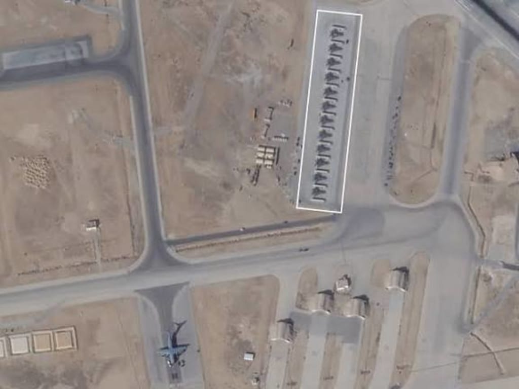
Satellite photos captured late last month indicate that U.S. military assets are concentrated at multiple bases and maritime zones within striking range of Iran. The imagery shows at least a dozen F-15E Strike Eagle fighter jets and A-10C ground-attack aircraft stationed at Muwaffaq Salti Air Base in Jordan, positioned northwest of Iraq and within operational distance of Iranian airspace.
In addition to fighter jets, the imagery shows electronic warfare aircraft, aerial refueling tankers, and surveillance platforms — all of which enhance U.S. operational flexibility in a potential crisis. The presence of tankers, such as KC-135s, suggests the United States is preparing to sustain long-range flight operations without relying solely on regional allies for basing support.
Naval Forces in Key Strategic Waters
Satellite tracking and open-source satellite images also highlight a robust naval presence in waters near Iran. A group of U.S. Navy warships, including guided-missile destroyers and an aircraft carrier strike group, has been documented operating in the North Arabian Sea and near the Strait of Hormuz, a chokepoint through which a significant portion of the world’s oil supply transits.
The Washington Post +1
The USS Abraham Lincoln carrier strike group — often accompanied by F-35s and electronic warfare planes — has been positioned within hundreds of miles of Iran’s southern coast. This location allows for rapid response if tensions erupt, but also serves as a visible deterrent intended to change Tehran’s strategic calculus.
The Washington Post
Strategic Bases Near the Conflict Zone
While satellite images focus on the presence of U.S. aircraft and ships, the deployment is broader. Sources indicate that multiple U.S. destroyers are also patrolling the eastern Mediterranean and Red Sea, possibly ready to support naval operations or protect sea lanes if the conflict expands.
caspianpost.com
Moreover, surveillance from space and commercial geospatial data reveal that U.S. forces have been reinforcing air defenses and monitoring traffic at forward bases across the Persian Gulf region. These actions are part of a broader posture adjustment that includes increased intelligence, surveillance, and reconnaissance (ISR) missions, enabling commanders to track movements of Iranian forces and proxies across the Middle East. Although official personnel numbers and exact positions are classified, the patterns are visible from orbit.
Why the Buildup Matters
The United States’ visible presence near Iran comes amid heightened geopolitical tension. Washington and Tehran have been engaged in a complex dance of diplomacy and deterrence. President Donald Trump and his administration have combined military pressure with overtures for negotiations, challenging Iran to curb its nuclear ambitions while warning of potential consequences.
The Washington Post
The satellite images showing U.S. military positioning are interpreted by analysts as part of a strategy to avoid surprise escalation. By deploying advanced aircraft, naval groups, and support assets, the U.S. appears to be signaling it can respond rapidly to threats — whether they originate from Iran’s ballistic missile capabilities or from proxy forces active across Iraq, Syria, and Yemen.
military.com
At the same time, the images underscore the delicate balance Washington seeks to maintain: projecting strength without provoking a broader regional war. This approach is reflected in recent incidents, including the downing of an Iranian Shahed-139 drone that approached a U.S. aircraft carrier group, which U.S. forces shot down as a defensive measure.
The Washington Post
Tensions, Diplomacy, and Regional Stability
While the satellite imagery shows where U.S. forces are positioned, it also illustrates the broader strategic environment. The Middle East has become a theater of overlapping security concerns — from Iran’s nuclear activities and missile programs to Houthi attacks on shipping in the Red Sea. Satellite documentation provides policymakers and the public with concrete evidence of where and how the United States is posturing to meet these threats.
The deployment of U.S. aircraft and ships is often accompanied by diplomatic engagement. For example, negotiations involving U.S. envoys and Iranian officials have been discussed in neutral venues like Oman and Turkey, even as military assets remain in nearby waters.
AP News
These dual tracks — military readiness and diplomatic outreach — reflect Washington’s strategy of maintaining leverage while avoiding unintended escalation. Satellite images give an unfiltered view of the former, showing that the United States is prepared to respond swiftly to any significant escalation involving Iran or its allies.
Limitations of Satellite Imagery
It is important to understand what satellite imagery can and cannot reveal. While such images can show the locations of aircraft on airfields, ships at sea, and changes in force posture, they do not always capture covert deployments, underground infrastructure, or classified special-operations elements. The imagery typically comes from commercial providers or open-source analysis and must be interpreted within context.
Still, these images are valuable because they provide an independent check on official narratives and help the public understand the scale of military deployments and the strategic stakes involved.
Conclusion
Satellite imagery showing where the U.S. military is positioned near Iran paints a picture of a robust and multifaceted deployment. From jets in Jordan to warships near critical waterways, the U.S. presence is designed to signal readiness, deter escalation, and preserve options.
As tensions with Tehran continue to ebb and flow between confrontation and diplomacy, the locations captured from space offer a snapshot of where the United States stands — literally and figuratively — in a region fraught with strategic risk.
About the Creator
Fiaz Ahmed
I am Fiaz Ahmed. I am a passionate writer. I love covering trending topics and breaking news. With a sharp eye for what’s happening around the world, and crafts timely and engaging stories that keep readers informed and updated.
Keep reading
More stories from Fiaz Ahmed and writers in The Swamp and other communities.
UN Security Council Condemns Latest Militant Attacks in Pakistan That Killed Dozens
The United Nations Security Council has strongly condemned a wave of militant attacks in Pakistan that left dozens of civilians and security personnel dead, calling the violence a threat to regional stability and reaffirming the international community’s commitment to combating terrorism in all its forms. The attacks, which occurred in multiple locations across the country, have intensified concerns about Pakistan’s security situation and the resurgence of militant groups operating in border regions.
By Fiaz Ahmed 4 days ago in The Swamp
Why Black History Matters in America?
The United States of America is celebrating their 250th anniversary in 2026. I'm proud to be an American and as someone who was born here, I wouldn't imagine myself living anywhere else. This is a country where opportunities are possible. Where anyone can be successful in anything they desire to do. Equality, community, and togetherness are the backbones of what America is and should be about. However, we have an administration who wants to erase and disregard those who have made positive, meaningful impacts in our country, specifically Black figures, such as Martin Luther King, Jr., Rosa Parks, and Maya Angelou. President Trump and his administration have been constantly complaining and fighting against what they call the "Woke agenda". They use this excuse as a distraction from other issues they refuse to address, such as the high cost of living, climate change, and inflation. That equality is dividing America, when in reality, it's bringing us together. Being woke is not tied to a specific political party. No matter where you stand on the political spectrum, you can still care about other people and their plights. Compassion and empathy for others isn't tied to a political party, either. We were taught as children to treat others the way we want to be treated and not judge others because they're different from us. Caring about others isn't a personal attack on your beliefs. It doesn't make you any less of a person. People who are easily offended over African American figures, past or present, or anything related to it, are grasping at straws. Current and future generations need to know who people like Harriet Tubman and Shirley Chisholm were, especially in the classroom. Black History is part of American History. It should be recognized, not hidden or forgotten. Besides, you can't shield children from everything, just because your feelings are easily hurt.
By Mark Wesley Pritchard 6 days ago in The Swamp
Lord Mandelson Resigns from Labour to Prevent Further 'Embarrassment' Over Epstein Ties
In a move that has sent shockwaves through the British political landscape, Lord Peter Mandelson, one of the Labour Party’s most influential and controversial figures, has announced his resignation from the party. His decision to step down, which he claims is to protect the party from "further embarrassment," comes in the wake of growing media scrutiny surrounding his alleged links to the notorious financier and convicted sex offender, Jeffrey Epstein.
By Ayesha Lashari6 days ago in The Swamp


Comments
There are no comments for this story
Be the first to respond and start the conversation.