
Blizzards, Thaw, Then Relentless Rain: Why Is the North East Getting Such a Soaking?
Climate change and jet stream shifts drive extreme weather swings Meteorologists explain the forces behind unprecedented rainfall Frozen ground and warm air systems combine to trigger widespread flooding Scientists warn volatile weather patterns are becoming the new normal 🔹 Neutral & Analytical How rapid temperature shifts are reshaping winter weather in the region From snowstorms to floods: the science behind the sudden change Why the North East is seeing more intense and unpredictable storms 🔹 Catchy & Engaging From whiteout to washout in a matter of days A season of extremes leaves communities underwater When winter and spring collide, the rain takes over

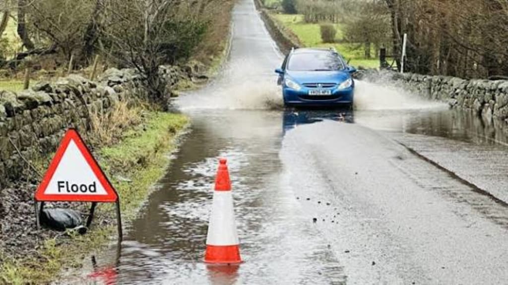
Communities across the North East have endured a dramatic sequence of extreme weather in recent weeks — blizzards followed by sudden thawing and then days of relentless rain. Roads have flooded, rivers have burst their banks, and emergency services have been stretched as residents struggle to adapt to rapidly changing conditions. Meteorologists say the unusual pattern is the result of a powerful mix of atmospheric forces linked to climate change and shifting global weather systems.
The region first experienced heavy snowfall as Arctic air swept south, bringing freezing temperatures and blizzard conditions to areas unaccustomed to prolonged snow events. Schools closed, transport networks stalled, and rural communities were briefly cut off. But the cold spell did not last. Within days, temperatures rose sharply, melting accumulated snow and saturating already frozen ground. When intense rain followed, the landscape had little capacity to absorb the water.
This sequence — snow, thaw, and heavy rain — created the perfect conditions for flooding.
A Clash of Air Masses
Weather experts explain that the North East has become a battleground between cold polar air and warm, moisture-rich systems arriving from the Atlantic. Jet stream instability has allowed these contrasting air masses to collide more frequently and with greater intensity.
“The jet stream is behaving more erratically than in the past,” said one senior meteorologist. “It’s pulling down Arctic air one week and then swinging back north to allow warm, wet systems to dominate the next. That back-and-forth pattern is exactly what we’ve been seeing.”
As warm air moves over cold ground and snow cover, it accelerates melting while carrying large volumes of moisture. The result is prolonged rainfall rather than brief showers, overwhelming drainage systems and swelling rivers.
Climate Change as a Multiplier
Scientists are cautious about attributing any single storm to climate change, but they agree that warming temperatures are amplifying weather extremes. Warmer air holds more moisture, increasing the potential for heavy rainfall. At the same time, weakened polar circulation allows cold air to travel farther south, creating sharper contrasts in temperature.
In the North East, this has meant more frequent swings between winter and spring conditions in a matter of days. These rapid shifts prevent the land from stabilizing and make flooding more likely.
Urban areas have been particularly vulnerable. Older drainage systems were designed for gentler rainfall patterns and cannot cope with sustained downpours. In some towns, floodwater poured into basements and shops, forcing businesses to close temporarily and residents to evacuate.
Rivers Under Pressure
Hydrologists report that river levels rose at unprecedented speed due to the combined impact of melting snow and rainfall. Unlike summer storms, where dry soil can absorb much of the water, frozen or waterlogged ground allows runoff to flow directly into rivers and streams.
Several flood warnings were issued across the region as reservoirs approached capacity. Authorities opened spillways to prevent dam failures, while sandbags were distributed to vulnerable neighborhoods.
Farmers have also suffered heavy losses. Fields were submerged, livestock had to be moved to higher ground, and crops already planted were damaged by standing water. The agricultural sector fears that unpredictable weather will increasingly disrupt food production cycles.
Infrastructure Strains
Transport networks have faced repeated disruption. Rail services were suspended in some areas due to landslides and track flooding. Major roads became impassable after drainage channels overflowed. Utility companies reported power outages linked to fallen trees and water-damaged substations.
Local governments say the cost of repairs is mounting. Bridges, culverts, and flood defenses that were once considered sufficient are now being tested beyond their design limits.
Emergency planners warn that these conditions may become more common unless infrastructure is modernized. Investment in flood barriers, river management, and urban drainage is now seen as urgent rather than optional.
A Pattern, Not an Exception
Long-term data shows that the North East is experiencing more intense rainfall events than in previous decades. Seasonal averages may not look dramatic, but the way precipitation falls has changed — concentrated into fewer, heavier storms instead of steady light rain.
Weather forecasters say this pattern increases the risk of flash flooding and makes prediction more difficult. Sudden downpours can overwhelm communities with little warning, while melting snow adds an unpredictable extra layer of risk.
Residents have begun to notice the shift. Longtime locals describe winters that once brought steady cold now replaced by wild fluctuations between freezing nights and mild, rainy days. This volatility is reshaping how people prepare for seasonal weather.
Looking Ahead
Forecasts suggest that more rain is likely in the coming weeks, raising concerns that rivers may not have time to return to normal levels before the next storm arrives. Authorities are urging residents in flood-prone areas to stay alert and prepare emergency plans.
Experts emphasize that adaptation is key. Improved forecasting, upgraded drainage systems, and better land-use planning can reduce the impact of extreme weather. Natural solutions, such as restoring wetlands and floodplains, can also help absorb excess water before it reaches towns and cities.
The recent soaking of the North East is not just a story of bad luck or seasonal variation. It reflects a changing climate where extremes are becoming the new normal. Blizzards followed by sudden thaw and relentless rain may once have been rare. Now, they are a warning of what future winters could increasingly look like.
For residents still drying out from flooded homes and roads, the question is no longer why this happened once — but how often it will happen again.
About the Creator
Fiaz Ahmed
I am Fiaz Ahmed. I am a passionate writer. I love covering trending topics and breaking news. With a sharp eye for what’s happening around the world, and crafts timely and engaging stories that keep readers informed and updated.
Keep reading
More stories from Fiaz Ahmed and writers in The Swamp and other communities.
Japan to Restart World’s Biggest Nuclear Plant
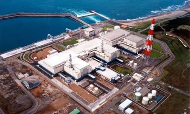
Japan is preparing to restart the world’s largest nuclear power plant, a landmark decision that signals a major shift in the country’s energy policy more than a decade after the Fukushima disaster reshaped public attitudes toward nuclear power. The Kashiwazaki-Kariwa nuclear plant, located in Niigata Prefecture on Japan’s northwest coast, is set to resume operations following regulatory approval and renewed political backing from the central government. The plant, operated by Tokyo Electric Power Company (TEPCO), has a total capacity of more than 8,000 megawatts, making it the largest nuclear facility in the world by output. It has remained offline since 2011, when Japan shut down nearly all of its nuclear reactors in the aftermath of the Fukushima Daiichi nuclear accident triggered by a massive earthquake and tsunami. Energy Security and Climate Goals Japan’s decision to restart the Kashiwazaki-Kariwa plant comes amid growing concerns over energy security and rising fuel costs. Since the nuclear shutdowns, the country has relied heavily on imported fossil fuels such as liquefied natural gas (LNG), coal, and oil to meet its electricity needs. This dependence has made Japan vulnerable to global energy price fluctuations and geopolitical tensions. Government officials argue that restarting nuclear plants is essential to ensuring a stable and affordable energy supply. “Nuclear power plays a critical role in achieving both energy security and carbon reduction targets,” said a senior official from Japan’s Ministry of Economy, Trade and Industry (METI). “Restarting Kashiwazaki-Kariwa will significantly strengthen our electricity system and reduce reliance on fossil fuels.” Japan has pledged to achieve carbon neutrality by 2050, and nuclear power is seen as a key component of that strategy. The government aims to raise the share of nuclear energy in its power mix to between 20 and 22 percent by 2030, compared with much lower levels in recent years. Safety and Regulatory Hurdles The restart of Kashiwazaki-Kariwa has not been without controversy. The plant faced serious setbacks in recent years after security breaches were discovered in 2021, including failures in access control systems and monitoring equipment. These lapses led Japan’s Nuclear Regulation Authority (NRA) to suspend operations until TEPCO could demonstrate that it had addressed the problems. Following extensive inspections and corrective measures, the NRA lifted the operational ban in late 2023, clearing the way for preparations to restart one of the plant’s seven reactors. TEPCO has since upgraded security systems, improved employee training, and implemented stricter oversight procedures. Despite regulatory approval, local consent remains a major hurdle. Under Japan’s informal rules, nuclear plants cannot resume operations without the agreement of local governments. Niigata’s governor has taken a cautious stance, insisting that public trust must be restored before giving final approval. “We must ensure that safety is fully guaranteed and that lessons from Fukushima are never forgotten,” the governor said in a recent statement. Public hearings and expert panels are expected to play a role in the final decision.Technological and Safety Upgrades TEPCO has invested billions of dollars in safety upgrades at Kashiwazaki-Kariwa. These include reinforced seawalls, improved backup power systems, upgraded control rooms, and stricter security protocols to prevent unauthorized access. The plant has also installed new equipment designed to prevent hydrogen explosions like those seen at Fukushima. Emergency drills involving local governments and first responders have been conducted to test evacuation and disaster-response plans. Regulators emphasize that Japan’s post-Fukushima safety standards are among the strictest in the world. Reactors must pass comprehensive inspections and stress tests before restarting, and utilities face heavy penalties for violations. Still, critics argue that no technological fix can fully eliminate the risks associated with nuclear power, particularly in a country prone to earthquakes and typhoons. Global Implications Japan’s move to restart the world’s largest nuclear plant will be closely watched by other nations reconsidering nuclear energy as part of their climate strategies. Countries such as Germany have moved away from nuclear power entirely, while others, including France and Britain, are investing in new reactors. If Kashiwazaki-Kariwa resumes operations successfully, it could strengthen the case for nuclear power as a low-carbon alternative to fossil fuels. A failure or new scandal, however, could reinforce fears and reignite opposition. The decision also carries symbolic weight. Kashiwazaki-Kariwa represents both the promise and peril of nuclear technology: immense power generation on one hand, and potentially catastrophic risk on the other. A High-Stakes Restart The restart is expected to occur in phases, with one reactor coming online first before others follow. TEPCO and government officials insist that caution will guide the process and that public safety remains the top priority. For Japan, the reopening of the world’s biggest nuclear plant is more than an energy policy choice. It is a test of whether the nation has learned from its past and can balance technological ambition with accountability and transparency. As the reactors prepare to hum back to life, Japan stands at a crossroads between its nuclear legacy and its future energy needs. Whether this decision proves wise will depend not only on engineering and regulation, but on rebuilding public trust in a technology that once promised prosperity and delivered disaster.
By Fiaz Ahmed 2 days ago in The Swamp
Why Black History Matters in America?
The United States of America is celebrating their 250th anniversary in 2026. I'm proud to be an American and as someone who was born here, I wouldn't imagine myself living anywhere else. This is a country where opportunities are possible. Where anyone can be successful in anything they desire to do. Equality, community, and togetherness are the backbones of what America is and should be about. However, we have an administration who wants to erase and disregard those who have made positive, meaningful impacts in our country, specifically Black figures, such as Martin Luther King, Jr., Rosa Parks, and Maya Angelou. President Trump and his administration have been constantly complaining and fighting against what they call the "Woke agenda". They use this excuse as a distraction from other issues they refuse to address, such as the high cost of living, climate change, and inflation. That equality is dividing America, when in reality, it's bringing us together. Being woke is not tied to a specific political party. No matter where you stand on the political spectrum, you can still care about other people and their plights. Compassion and empathy for others isn't tied to a political party, either. We were taught as children to treat others the way we want to be treated and not judge others because they're different from us. Caring about others isn't a personal attack on your beliefs. It doesn't make you any less of a person. People who are easily offended over African American figures, past or present, or anything related to it, are grasping at straws. Current and future generations need to know who people like Harriet Tubman and Shirley Chisholm were, especially in the classroom. Black History is part of American History. It should be recognized, not hidden or forgotten. Besides, you can't shield children from everything, just because your feelings are easily hurt.
By Mark Wesley Pritchard 6 days ago in The Swamp


Comments
There are no comments for this story
Be the first to respond and start the conversation.