
Auden Col Trek: One of the Most Difficult Treks in India
Embark on the thrilling Auden’s Col Trek which is one of the most difficult treks in India, guided by experts of Himalayan Dream Treks (HDT), with the epic journey of trekking in Uttarakhand from Gangotri to Kedarnath.
Auden's Col may not be widely known, but it holds significant prominence in Indian literature and mountaineering. Standing at an elevation of 5,242 meters, it separates the Jogin I and Gangotri III peaks while also linking the Rudragaira and Bhilangna Valleys. Additionally, this high-altitude pass is nestled between two massive glaciers—Khatling and Jogin I. It was first discovered by John Bicknell Auden, a renowned geologist and explorer, who became the first to cross it from the Rudragaira side and descend to Kedarnath in 1939. As a result, the pass was named in his honor. With such an abundance of natural wonders, Auden's Col offers the true thrill of a mountaineering expedition, making it highly significant in the mountaineering world.
Beyond crossing the pass, if one continues further, the trek concludes at Kedarnath—one of the revered Char Dham and among the 12 Jyotirlingas. Thus, Auden's Col is not just a high-altitude pass crossing but a route connecting two Char Dham pilgrimage sites, Gangotri and Kedarnath. Along the journey, trekkers encounter breathtaking crystal-clear lakes such as Sukhatal, Masar Tal, and Vasuki Tal. And where there are lakes, there are also vast meadows. The early campsites of the trek are set against picturesque grasslands beside the Rudragaira and Bhilangna rivers, offering a surreal experience.
But the adventure doesn’t end there. While the landscapes are truly mesmerizing, the trek demands courage, as it involves navigating high ridges, knee-deep snow, and treacherous crevasses. The route remains steep for the most part, requiring trekkers to traverse thick snow carpets and unstable rocky terrain. The descent from Auden’s Col towards the Khatling Glacier is particularly challenging, with enormous crevasses capable of making even seasoned trekkers apprehensive.
Undoubtedly, Auden's Col is among the toughest treks in the Himalayas. However, every challenge along the way is rewarded with extraordinary views. It encompasses all the elements of an exceptional Himalayan trek combined with the thrill of a true mountaineering expedition.
Why Auden' Col Trek Is A Must-Do Trek
1. Historical Significance:
- Auden's Col holds a prominent place in Indian literature and mountaineering.
- Named after John Bicknell Auden, a pioneering geologist and explorer who first crossed the pass in 1939.
2. Unique Geographical Features:
- Connects Rudragaira and Bhilangna Valleys, offering a diverse and breathtaking landscape.
- Positioned between the massive Khatling and Jogin I glaciers, providing a stunning backdrop throughout the trek.
3. Spiritual Journey:
- More than just a challenging trek, Auden's Col holds spiritual significance as it connects the Char Dham sites of Gangotri and Kedarnath.
- The expedition culminates at Kedarnath, one of the sacred Char Dhams and a revered Jyotirlinga, making it a deeply spiritual experience.
4. Enchanting Lakes and Meadows:
- Showcases mesmerizing crystal-clear lakes such as Sukhatal, Masar Tal, and Vasuki Tal along the route.
- Features stunning meadows, with picturesque camping spots beside the Rudragaira and Bhilangna rivers.
5. Challenging Terrain:
- Involves navigating through knee-deep snow, high ridges, and treacherous crevasses, making it one of the most demanding Himalayan expeditions.
- The route consists of steep ascents, requiring trekkers to tackle snow-covered landscapes and rugged rocky terrains.
6. Dreadful Descent:
- The descent from Auden's Col towards Khatling Glacier is considered one of the most difficult and nerve-wracking sections.
- Trekkers must negotiate massive crevasses, adding both danger and thrill to this high-altitude adventure.
7. Spectacular Views:
- Despite its challenges, Auden's Col rewards trekkers with awe-inspiring vistas, making every hardship worthwhile.
- Offers panoramic views of surrounding peaks, glaciers, and valleys, creating an unforgettable Himalayan experience.
8. Himalayan Wilderness:
- Immerse yourself in the untouched beauty of the Himalayas, far from the chaos of city life.
- Encounter diverse flora and fauna, allowing a deeper connection with nature in its purest form.
9. Cultural Exploration:
- Gain insights into the region’s rich culture and traditions as the trek passes through remote villages and settlements.
- Engage with local inhabitants, experiencing the unique cultural heritage that defines the Himalayan way of life.
Auden's Col Trek Itinerary
Day 1: Dehradun to Gangotri
- Altitude: 3,100 m / 10,200 ft (Gangotri)
- Pickup: 6:00 AM from Prince Chowk, Dehradun
- Drive: 240 km, 8-9 hours
- Meals: Breakfast and lunch on the way (not included in cost)
- Weather Tip: Keep a warm jacket handy after Uttarkashi
- Facilities: Local market, mobile network, and a fully functioning ATM at Uttarkashi
- Gangotri Highlights: One of the Char Dhams of Uttarakhand
- Stay: Guest house (double/triple sharing), dinner included
Upon reaching Dehradun, get ready for a long yet scenic drive to Gangotri, a significant religious site in India. You will pass through Uttarkashi, home to the renowned NIM (Nehru Institute of Mountaineering), and a town located on the banks of the Bhagirathi River. The journey takes you through temple-filled towns and dense forests, culminating in your arrival at Gangotri in the evening.
Situated along the Bhagirathi River, Gangotri is one of the revered Char Dhams, drawing large numbers of pilgrims in March and April. Many foreign travelers also visit this sacred town. While the local market and interactions with the locals are worth exploring, it’s best to rest at the hotel and leave sightseeing for the next day.
Day 2: Rest and Acclimatization at Gangotri
- Activities: Visit Pandav Gufa, Gauri Kund, and Surya Kund after breakfast
- Post-lunch, explore Gangotri Temple or shop in the local market
- Meals: Lunch at the guest house
- Stay: Guest house
Wake up in the spiritual atmosphere of Gangotri. Utilize this day to explore the area and acclimatize. Visit nearby temples, caves, and forests, and interact with sadhus. As a group, explore Surya Kund, Pandav Gufa, and Gauri Kund. Don’t miss the evening Aarti at the temple, an unforgettable experience. Staying outdoors will aid in acclimatization, preparing you for the trek ahead.
Day 3: Gangotri to Nala Camp
- Altitude: 3,750 m / 12,300 ft
- Altitude Gain: 650 m / 2,100 ft
- Trek Distance: 8 km | Duration: 6-7 hours
- Terrain: Moderate walk with steep ascents
- Walk alongside Bhagirathi River before merging with Rudragaira River
- Cross a log bridge after 2 hours
- Pass through Pine, Cedar, Rhododendron, and Birch forests
- First glimpses of Gangotri III and Jogin II peaks before reaching camp
- Meals: Packed lunch on the way
- Stay: Tent (twin sharing)
With proper acclimatization at Gangotri, start your trek towards Nala Camp. The 6-7 hour trek begins with a descent into the valley, followed by a scenic walk along the Bhagirathi River. After 2 km, cross a log bridge and enter the Rudragaira Valley, gradually making your way through thick forests of Pine, Cedar, Rhododendrons, and Birch.
The terrain suddenly becomes steeper, with some sections crossing a rockfall zone, so proceed cautiously. As the altitude increases, the dense forests give way to meadows dotted with flowers. You’ll finally arrive at the campsite, located in a stunning meadow beside the Rudragaira River, offering breathtaking views of Gangotri III and Jogin II.
Day 4: Nala Camp to Rudugaira Camp
- Altitude: 4,350 m / 14,300 ft
- Altitude Gain: 600 m / 2,000 ft
- Trek Distance: 7 km | Duration: 7-8 hours
- Terrain: Steep and strenuous climb throughout
- Spectacular views of Rudragaira Peak, Jogin Peak, and Auden’s Col
- Cross streams and landslide-prone areas
- Limited water sources on the way (carry enough)
- Meals: Packed lunch
- Stay: Tent
Though shorter in distance, today's trek is steep and strenuous. Carry ample water as there are limited sources along the way. The ascent takes you through high-altitude meadows and multiple stream crossings before leading into landslide-prone sections.
As you approach the campsite, the terrain becomes steeper with snow patches appearing. Despite the challenge, the day is rewarding with breathtaking views of Rudragaira Peak, Jogin Peak, and Auden’s Col. After an exhausting trek, settle into your tents at Rudragaira Camp for the night.
Day 5: Rest and Acclimatization
- Activity: Explore the campsite, surrounded by towering peaks
- Optional: Short hike to a ridge near Rudragaira Peak
- Meals: Hot lunch at the campsite
- Stay: Tent
Acclimatization is crucial at this altitude. Spend the day exploring the stunning meadows and riverbanks of Rudragaira Camp. Take a short hike to a ridge offering panoramic mountain views. Staying outdoors helps your body adjust better to the altitude.
Day 6: Rudugaira Camp to Auden’s Col Base Camp via Gangotri Base Camp
- Altitude: 4,750 m / 15,600 ft
- Altitude Gain: 400 m / 1,300 ft
- Trek Distance: 8 km | Duration: 6-7 hours
- Terrain: Gradual but tricky ascent on moraine
- Beautiful views of Gangotri peaks
- Pass Sukha Tal on the way
- First clear view of the gully leading to Auden’s Col
- Meals: Packed lunch
- Stay: Tent
An exciting yet demanding day awaits. The trek starts with a morain-covered trail, leading past a landslide-prone section before reaching a ridge. After a steep descent to Bakriwala Camp, another ridge comes into view, requiring a tricky walk over loose scree.
Further down, you’ll reach Gangotri Base Camp. Along the way, you will pass the serene Sukha Tal before setting up camp on the flat moraine surface at Auden’s Col Base Camp. The view of the gully leading to Auden’s Col is truly mesmerizing.
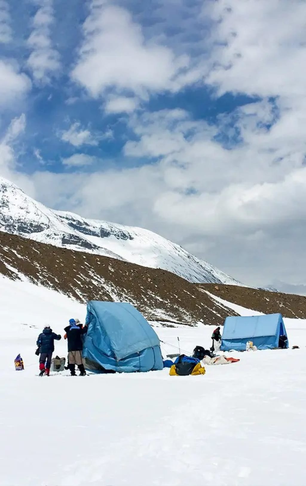
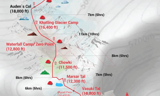
Day 7: Auden’s Col Base Camp to Khatling Glacier Camp via Auden’s Col
- Auden’s Col: 5,500 m / 18,000 ft
- Khatling Glacier Camp: 5,000 m / 16,400 ft
- Altitude Gain: 750 m / 2,400 ft
- Trek Distance: 12 km | Duration: 10-12 hours
- Base Camp to Auden’s Col: 5 km, 5-6 hours (steep ascent)
- Auden’s Col to Khatling Glacier: 7 km, 5-6 hours (steep descent)
- Difficult ascent to the Col, followed by a treacherous descent
- Khatling Glacier known for deep crevasses
- Always roped up, follow trek leader’s instructions
- Meals: Packed lunch
- Stay: Tent
Today is the most challenging, longest, and thrilling part of the trek. The day begins with a steep climb on moraine, with Rudragaira Glacier visible on your right. The final stretch towards Auden’s Col requires roping up.
At the Col, you’ll witness the daunting Khatling Glacier, known for its deep crevasses. The descent is steep (70-degree slope), nerve-wracking, and requires careful navigation. After reaching the flat glacier floor, you will set up camp amidst the rugged moraine landscape of Khatling Glacier.
Day 8 - Khatling Glacier Camp to Zero Point/Waterfall Camp
- Altitude: 3,900 m / 12,800 ft (Zero Point).
- Altitude Loss: 1,100 m / 3,600 ft.
- Trek Distance: 11 km | 9-10 hours.
- Terrain: 8 km of glacier trekking.
- The first half of the trail consists of loose gravel, scree, and black ice, while the remaining part is moraine.
- Campsite: Alongside the Bhilangna River.
- Fun Fact: The Bhilangna River eventually meets the Tehri Dam.
- Meals: Packed lunch.
- Accommodation: Stay in tents.
One of the longest and most challenging trekking days. The journey continues along the Khatling Glacier to reach Zero Point Camp. The first 50 meters involve a steep descent, so careful footing is crucial. Snow will cover the trail, making the descent technical. The initial 2 km require careful navigation down the glacier, leading to the moraines.
The path is scattered with loose rocks and scree, and trekkers will encounter black ice, icefalls, and large ice formations. Crevasse navigation is necessary. The Bhilangna River originates from the snout of the Khatling Glacier. The final section consists of rockfall and boulders before reaching the campsite.
Day 9 - Rest Day
- Purpose: Mandatory rest day for rejuvenation. Can be used as a buffer day if needed.
After several days of challenging trekking, this day is reserved for relaxation and recovery. If required due to unforeseen circumstances, it may serve as a contingency day.
Day 10 - Waterfall Camp/Zero Point to Chowki
- Altitude: 3,500 m / 11,500 ft (Chowki).
- Altitude Loss: 400 m / 1,300 ft.
- Trek Distance: 8 km | 5-6 hours.
- Terrain: Meadows with greenery.
- Follow the Bhilangna River for the first 3 km.
- Campsite: Set on vast grasslands.
- Meals: Packed or hot lunch depending on group pace.Accommodation: Stay in tents.
After a rest day, trekkers will feel refreshed. The trek begins along the valley, following the Bhilangna River for 3 km. A wooden bridge crosses the river’s fierce current. Soon, lush meadows appear, providing an excellent rest stop.
The remaining 4 km lead to Chowki, one of the trek’s most picturesque campsites, nestled in expansive grasslands surrounded by towering peaks.
Day 11 - Chowki to Masar Tal
- Altitude: 3,750 m / 12,300 ft (Masar Tal).
- Altitude Gain: 250 m / 800 ft.
- Trek Distance: 8 km | 5-6 hours.
- Terrain: Steep ascent followed by a gradual walk.
- Campsite: Near the pristine Masar Tal lake.
- Highlights: Stunning views of Thalay Sagar Peak.
- Accommodation: Stay in tents.
A relatively easy day with a gradual altitude gain towards Masar Tal. The trek begins with a short ascent, revealing breathtaking views of Thalay Sagar. The trail crosses several ridges and a small stream before reaching the glacial lake, Masar Tal, which beautifully mirrors the surrounding peaks. Camping beside this lake is a truly special experience.
Day 12 - Masar Tal to Vasuki Tal via Mayali Pass
- Altitude: 5,000 m / 16,400 ft (Mayali Pass).
- Altitude: 4,200 m / 13,800 ft (Vasuki Tal).
- Altitude Gain: 1,250 m / 4,100 ft.
- Trek Distance: 12 km | 7-9 hours.
- Masar Tal to Mayali Pass: 6 km | 5-6 hours.
Mayali Pass to Vasuki Tal: 6 km | 2-4 hours.Terrain: Steep ascent to Mayali Pass, followed by a steep technical descent.No water sources on the way.Campsite: Near Vasuki Tal Lake.Meals: Packed lunch.Accommodation: Stay in tents.
Today marks the final pass crossing—Mayali Pass. The trail begins with a boulder-filled ascent to Masar Top, followed by another 45-minute climb to the pass base. A partially frozen lake with floating icebergs adds to the beauty of this point.
A flat, gradual section follows, with some crevasses similar to Khatling Glacier but easier to navigate. The top of Mayali Pass is a moment of triumph. The descent, though steep and filled with boulders, rewards trekkers with views of the Peenya Tal twin lakes before reaching Vasuki Tal.
Day 13 - Vasuki Tal to Kedarnath
- Altitude: 3,500 m / 11,600 ft (Kedarnath).
- Altitude Loss: 700 m / 2,200 ft.
- Trek Distance: 7 km | 3-5 hours.
- Terrain: Well-marked descent.
- Highlights: Visit the sacred Kedarnath Temple, dedicated to Lord Shiva.
- Meals: Hot lunch at the guesthouse.Accommodation: Stay in a guesthouse.
The final stretch of the trek leads to Kedarnath, one of the Char Dham pilgrimage sites and a revered Jyotirlinga. The day starts with an ascent to Vasuki Tal top, offering a ridge walk filled with boulders.
A long and steep descent follows, revealing lush greenery. The first glimpse of Kedarnath village, set beside the Mandakini River, is truly rewarding. In the evening, pay homage at the Kedarnath Temple.
Day 14 - Kedarnath to Gaurikund
- Altitude: 1,950 m / 6,400 ft (Gaurikund).
- Altitude Loss: 1,550 m / 5,200 ft.
- Trek Distance: 14 km | 6-7 hours.
- Terrain: Well-marked descent.
- Highlights: Numerous shops and water points along the way.
- Optional: Helicopter ride (not included in cost).
- Meals: Hot lunch at the guesthouse.Accommodation: Stay in a guesthouse.
A long descent marks the final trekking day. The well-defined path allows trekkers to soak in the last moments in the mountains.
Day 15 - Gaurikund to Rishikesh
- Driving Distance: 250 km | 10 hours.
- Departure: Morning tea before the drive to Rishikesh.
- Meals: Breakfast and lunch not included in trek cost.
- Arrival: Reach Rishikesh by 6:00-7:00 pm. For onward journeys, book post 8:30 pm.
After an unforgettable adventure, the journey back home begins with a scenic drive to Rishikesh.
Note:
- Keep a buffer day in your travel plan.
- If unused, explore Rishikesh.
- Read the article: Things to do in Rishikesh.
- Distances, altitudes, and trek durations are approximate.
- Carry original and photocopies of ID proof.
- Arrive a day early if traveling by air.
How to Reach the Auden Col Trek' Starting Point-
It is mandatory for all participants to reach Prince Chowk, Dehradun, by 6:00 AM.
If you have opted for Himalayan Dream Treks (HDT)'s pick-up service, your journey from Dehradun onwards will be arranged by HDT. You can select this option while booking the trek by adding it as an add-on.
Options to Reach Dehradun
To reach Dehradun, you can first arrive at Delhi, Dehradun Airport, or Chandigarh. Below are the travel options from these locations:
By Train: Take an overnight train from Delhi to Dehradun.
By Bus: Board a bus from Delhi (Kashmiri Gate ISBT) or Chandigarh (Sector 17 Bus Stand) to Dehradun ISBT, and then take local transport to the pickup location at Prince Chowk.
- Delhi to Dehradun: 250 km | Approx. 6 hours
- Chandigarh to Dehradun: 220 km | Approx. 5 hours
- Dehradun ISBT to Railway Station: 6 km | Approx. 15 minutes (without traffic)
(We strongly recommend choosing government buses over private buses outside the bus station. Based on experience, private buses have a higher chance of delays, whereas government buses are more reliable. Whichever option you choose, ensure that you reach Dehradun by 5:30 AM at the latest.)
By Flight: If traveling by air, you can land at Jolly Grant Airport, Dehradun. The distance from the airport to Prince Chowk is approximately 30 km, which takes around 1 hour. (If arriving by flight, it is advisable to reach a day earlier to avoid any delays.)
Drop-Off Information
- The designated drop-off point is Tapovan, Rishikesh.
- Expected arrival in Rishikesh: Between 6:30 - 7:30 PM.
- Plan onward travel after 10:00 PM for a safe buffer.
Note: If traveling during July and August, always keep a buffer day in your itinerary due to the monsoon season.
If the buffer day is not required for the trek, you can use it to explore Rishikesh.
(For those preferring to travel independently to the base camp without using HDT's pick-up service, government buses or private cabs are available from Rishikesh. Your trek coordinator will guide you in booking a bus or cab.)
HDT provides comfortable transport options, including Tempo Travelers, Bolero, or equivalent vehicles. If you wish to upgrade your mode of transportation, please contact your trek coordinator for assistance.
About the Creator
Shivam Chandra
I'm a nature lover, adventure enthusiast, and travel blogger who has trekked across Uttarakhand, Himachal, Ladakh, and Nepal. Exploring new places and discovering hidden trails is what inspires me.
Keep reading
More stories from Shivam Chandra and writers in Journal and other communities.
Auden Col Trek: A Detailed Route Map Guide to Unforgettable Himalayan Expedition
The trek route map taken during the Auden Col Trek follows: Rishikesh → Gangotri → Nala Camp → Rudragaira Base Camp → Auden Col Base Camp → Auden Col → Khatling Glacier Camp → Zero Point → Chowki → Masar Tal → Mayali Pass → Vasuki Tal → Kedarnath → Gauri Kund → Rishikesh
By Shivam Chandra11 months ago in Journal
Designing Aircraft for Arctic, Desert and Tropical Operations
Aircraft are often seen as symbols of freedom and global connectivity, but behind every successful flight lies an extraordinary engineering challenge designing machines that can operate reliably in the most extreme climates on Earth. From the frozen Arctic to scorching deserts and humid tropical regions, each environment pushes aircraft systems, materials, and performance limits in very different ways.
By Beckett Dowhan6 days ago in Journal
Silver Screen Magic with Mae West
American actress and singer Mae West became a popular film actress during the Great Depression. She started entertaining in vaudeville, then performed on Broadway, and finally went to Hollywood. She signed up with Paramount Pictures and made her debut in the 1932 film “Night After Night.” She also starred in musicals, comedies, and crime dramas. The American Film Institute named her one of the best classic Hollywood actresses.
By Rasma Raisters4 days ago in Geeks


Comments