

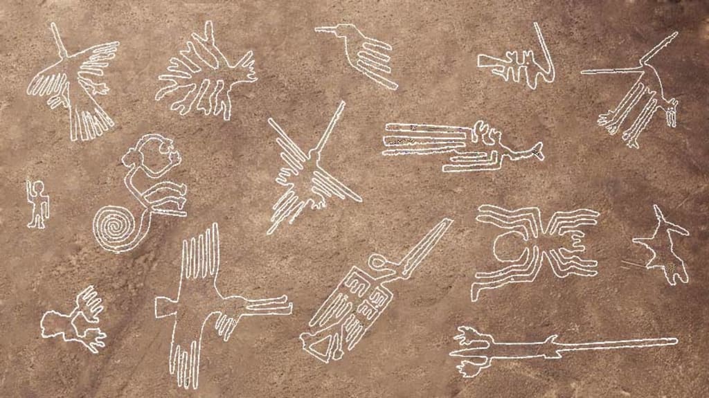
If you ever find yourself flying over the deserts of Southern Peru, you'll immediately notice distinctive white lines contrasting against the rusty red backdrop. Upon closer inspection, you'll discern clear shapes, including straight lines, rectangles, triangles, and captivating swirls. These formations appear as if they are integral parts of colossal drawings. Among these, you can spot representations of animals like monkeys, whales, condors, hummingbirds, and more. Remarkably, these lines were crafted over two millennia ago by the Nazca people.
Thanks to the dry climate and persistent desert winds, the majority of the Nazca Lines remain remarkably visible today. The Nazca people meticulously removed the top layer of pebbles to reveal the soil underneath, creating a striking contrast that varies from reddish-brown to yellowish-gray, resulting in an ever-changing appearance.
It seems that the creators of these lines began with small-scale models, gradually expanding them to create the magnificent full-scale designs we observe today. Scientists have endeavored to decipher the significance of the Nazca Lines ever since their discovery in the 1920s. Interestingly, the first mention of these lines dates back to the 16th-century Chronicle of Peru, where they were described as trail markers in the desert.
However, comprehensive study and understanding of the lines became possible only in the 1930s with the advent of commercial aviation. A decade later, American Professor Paul Kosok made a fascinating observation while researching the lines: he noticed that one line pointed directly at the setting sun, coinciding with the day after the winter solstice. This led scientists to conclude that the lines may constitute the world's largest astronomy book.
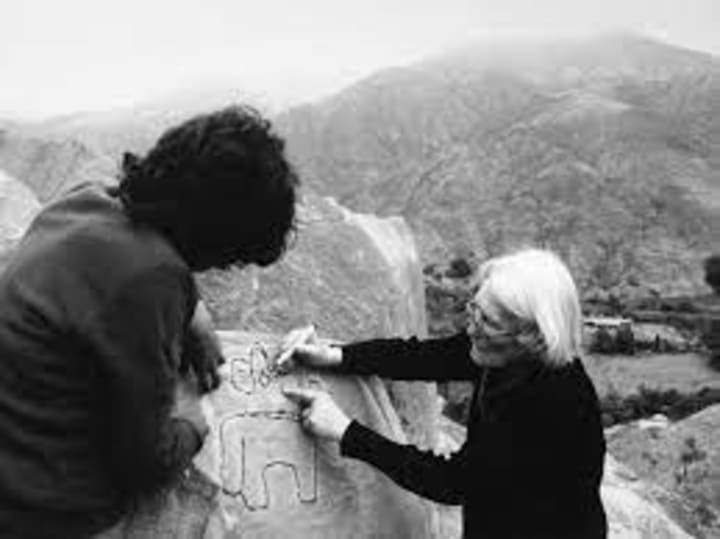
German scientist Maria Reiche, known as the 'Lady of the Lines,' supported the theory that the geoglyphs served as a calendar and had astronomical purposes. She dedicated four decades of her life to studying the lines, meticulously preserving them from unwanted visitors by living nearby.
In the 1970s, American researchers raised questions about the astronomy-related theory, suggesting that, in a region as arid as Nazca, water was a precious resource. They posited that straight lines and trapezoids may have been oriented toward locations for rituals aimed at securing water and enhancing crop fertility. The depiction of animals in the Andes region also seemed to be related to water, with spiders signifying rain, hummingbirds symbolizing fertility, and monkeys representing an abundance of water.
In recent years, the Nazca Lines have become a focal point for archaeologists from Yamagata University. They employ high-resolution aerial photography and drones to identify and document geoglyphs. The team has uncovered a total of 358 geoglyphs, with 168 discovered in 2022 alone. These geoglyphs feature depictions of humans, camelids, birds, orca whales, cats, and snakes, dating from approximately 100 BCE to 300 CE. Some of these images measure between 10 to 20 feet in length, while the largest geoglyphs span 1200 feet across.
Researchers believe that the Nazca Lines served as a form of communication in the desert, with linear ones indicating directions between valleys, and those drawn on slopes possibly marking ancient pathways between settlements. Utilizing artificial intelligence to analyze the images, the team identifies patterns in the geoglyphs' distribution, generating designs likely to be found in the desert, and then confirming their presence in the Nazca Lines.
One notable Peruvian geoglyph is the Candelabra, towering slightly taller than the Washington Monument, located on a seaside hill in the Paracas Peninsula. Researchers have dated it to approximately 200 BCE through nearby artifacts. While its appearance may resemble a candelabra, theories suggest it may represent an offering to an ancient deity or serve as a navigational beacon for sailors.
Effigy Mounds National Monument, situated along the Mississippi River, boasts 195 known Native American mounds. These mounds take various shapes, including conical forms and representations of animals such as birds, deer, turtles, bears, and panthers. Research indicates that the mounds date back to around 450 BCE, with the images somewhat younger. These mounds contain copper, bone, and stone tools, and their builders' descendants view them as ceremonial sites or markers of celestial events and territories.
The American Southwest and neighboring regions of Mexico feature over 300 intaglios—giant images engraved into the ground. Among these, the Blythe Intaglios in California, west of the Colorado River, are renowned. The Blythe Giants consist of six figures, including a human and an animal figure, believed to be between 450 and 2,000 years old. According to the local Mojave tribe, one figure represents Mastamho, the creator of life, while the animal figure is a mountain lion, his helper. The largest figure nearly matches the height of the Leaning Tower of Pisa. These intaglios remained hidden until a pilot flying over them accidentally discovered them in the 1930s. They are best observed from a helicopter.
Kazakhstan boasts its own version of the Nazca Lines, with around 260 earthworks in the northern part of the country. These step geoglyphs feature geometric shapes like squares, crosses, circles, and a three-prong design. Their creators used materials such as dirt, rocks, and lumber to craft them into the ground. Although archaeologists estimate their age at 8,000 years, the builders and their purpose remain shrouded in mystery. Some theories suggest these lines tracked the movement of the sun, and even NASA has taken interest due to their antiquity.
One striking aspect of these geoglyphs is their colossal size; one of the largest has sides as long as an aircraft carrier. It is a testament to the capabilities of ancient nomadic Stone Age tribes, as organizing such a vast workforce for a complex project challenges our understanding of their abilities.
Finally, in Oxfordshire, England, a white horse adorns a lush green hill, resembling modern art. However, it is among the oldest geoglyphs, dating back to the Bronze and Iron Ages. Its creation involved removing turf to reveal the chalky white soil underneath. The purpose behind this artwork remains speculative, with theories ranging from it being a fertility symbol to a territorial marker. Aerial images have documented its gradual transformation over centuries as the underlying soil has been revealed, unveiling a larger horse-like shape beneath its current appearance.
Thank you for joining us on this journey. If you enjoyed this content as much as I did, please don't hesitate to show your support by hitting the 'like' button and leaving your thoughts in the comments below. Feel free to share this with your friends too. Your time and engagement are greatly appreciated. We look forward to having you with us again soon. Until next time!
About the Creator
PorkChopBob
I'm hoping to bring some entertainment on subjects and topics that interest me and I hope you share my interest too.
Keep reading
More stories from PorkChopBob and writers in History and other communities.
The Green Revolution: How Renewable Energy Is Reshaping the World
In an era defined by environmental consciousness, one concept stands tall as a beacon of hope for a sustainable future: the green revolution. Renewable energy sources have emerged as the driving force behind a global transformation that promises cleaner skies, reduced carbon footprints, and a healthier planet. From wind turbines gracefully harnessing the wind's power to solar panels soaking up the sun's rays, renewable energy is reshaping the world in inspiring ways. In this article, we will explore the incredible impact of renewable energy, backed by real-life examples, and envision a future powered by clean energy for a more sustainable world.
By PorkChopBob2 years ago in Earth
3 Completely Innocent Decisions That Ended Very Badly
Most disasters don’t begin with villainous laughter or ominous music. They begin with someone making a perfectly reasonable decision. Sensible, even. The kind of choice you’d defend confidently if questioned later.
By Enoch Sagini3 days ago in History
Israel: A Land of Struggle, Faith, and Transformation
The land that is today Israel has been at the crossroads of civilizations for thousands of years. From the deserts of Negev to the fertile hills of Galilee, this land has witnessed the rise and fall of empires, the birth of religions, and the enduring hopes of peoples who called it home. In ancient times, it was known as Canaan, a region inhabited by diverse groups, each with their own gods, languages, and customs.
By The best writer 4 days ago in History


Comments
There are no comments for this story
Be the first to respond and start the conversation.