
And Now We Know How Easter Island Giants Were Moved
Moai Statues, Easter Islands

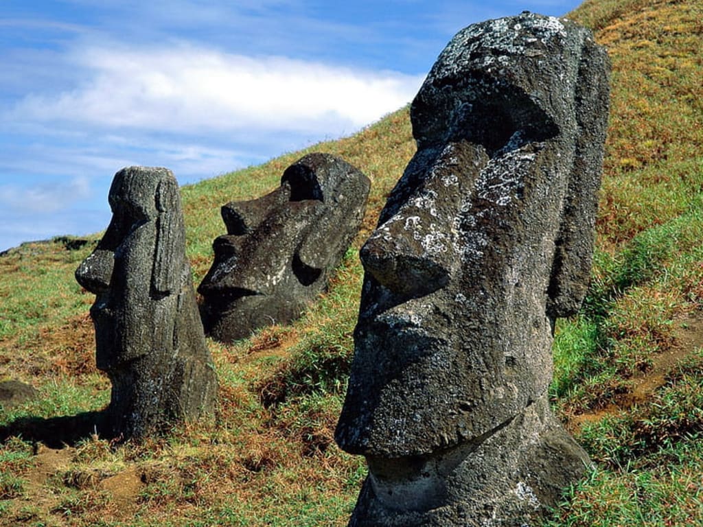
For centuries, the Easter Island giant heads, known as the moai statues, have captivated people worldwide and even earned their own emoji. The true significance behind these enigmatic figures has remained a mystery for hundreds of years. However, recent discoveries shed light on how they were constructed and moved to their permanent locations. Each moai statue comprises three distinct parts: a large yellow body, a red hat or top knot, and white inset eyes with a coral iris. Approximately 1,000 of these remarkable statues were created on Easter Island.
The process of crafting the moai involved sourcing volcanic tough from a local quarry that was once part of a volcano. These sturdy volcanic stones served as the primary material for the main bodies of most statues, enabling the islanders to bring these colossal creations to life.
"The material used to create the Moai statues on Easter Island was easy to carve during the initial stages. However, it posed challenges for transportation, which could be the reason why researchers discovered over 300 unfinished Moai in the Quarry. The completed statues, standing in various locations, appeared to watch over the villages and their inhabitants. It appears that the Moai were carved while lying on their backs, and later, the craftsmen detached them from the rock, moved them downhill, and then set them in an upright position to complete the carving process."
Once the construction of the statue was completed, the next challenging task was to transport it to its designated platform. This undertaking was no small feat, considering the statue's weight, which was comparable to half that of a house. To make matters even more daunting, the locals had no access to modern equipment or vehicles to aid them in this endeavor. Their ingenuity, however, came to the fore as they devised an original method to move the massive moai over a distance of three miles.
Much like the physical labor involved in moving houses during house relocations, this process required an extraordinary effort. Over time, researchers and scientists have been fascinated by the task and attempted to reconstruct how it might have been achieved. Various theories and experimental approaches were explored in a bid to understand the ancient techniques used by the locals.
One early hypothesis suggested that wooden sleds might have been utilized to pull replicas of the moai, much like how heavy objects were moved during that period. Another idea involved the potential use of palm trees for transportation purposes, but this theory was ultimately debunked due to the impracticality and limitations of such a method.
Among the different experiments conducted, the most successful approach thus far involves the use of ropes to rock the statue in an upright position along the road. This method gained credibility as it was mentioned in local legends, even finding reference in a traditional rap song.
According to these legends, the moai were believed to have "walked" from the Quarry to their final locations. The process likely involved a combination of ingenuity, determination, and community effort, making the moving of the statues a significant achievement and a testament to the resourcefulness of the people of that time.
In the early 20th century, a researcher named Catherine Rutledge made a significant discovery on the island - an 800-year-old Road Network. This intricate network consisted of pathways about 15 feet wide, which extended from the coast. Initially, Rutledge proposed that these roads had a ceremonial purpose and were not specifically constructed for transporting the moai. However, her theory received little attention at the time, and it didn't gain much recognition in the scientific community.
Several decades later, a renowned Norwegian adventurer and archaeologist named Thor Heredol presented his theory regarding the purpose of these ancient roads. According to Heredol, these pathways were indeed built with the primary intent of transporting the massive moai. He postulated that the roads served as crucial thoroughfares to move the statues from the quarries to their designated locations across the island. Interestingly, along these roads, some statues were seemingly dropped or left behind for reasons that still remain unclear.
Heredol's theory gained more prominence due to his reputation and status in the field of archaeology. As a result, it sparked renewed interest in understanding the intricate logistics and engineering achievements of the ancient islanders who managed to move these colossal stone statues across significant distances using nothing but their ingenuity and available resources.
In 2010, researchers made a fascinating discovery about the statues on the island. Contrary to the belief that the statues were randomly dropped, it was found that they were intentionally placed on hidden platforms, and the road floor on which they stood was uniquely U-shaped, making the task of pulling these massive statues along them quite challenging. Even today, about 15.5 miles of these ancient roads can be observed on the island through satellite images, confirming the remarkable engineering feat of the ancient civilization.
It appears that Catherine Rutledge's theory was accurate; these roads were likely constructed to facilitate pilgrims' journeys to a sacred volcano, with the Moai statues serving as significant signposts or markers along the way.
Halfway across the world, in Southern England, lies another historical enigma known as Stonehenge. This massive structure is steeped in mystery, and its purpose continues to be a subject of debate among scientists and researchers. Constructed over a period of approximately 1500 years by Neolithic Builders, Stonehenge comprises roughly 100 standing stones arranged in a circular formation. Various hypotheses have been proposed, suggesting that it could have been a symbolic representation of unity, a burial ground, or even an awe-inspiring sound illusion. Nonetheless, the true intention behind its creation remains an enduring puzzle to this day.
Every year, millions of tourists flock to witness the marvel, causing Heritage protectors to fret over the intrusion of a modern road that wound perilously close to this historical landmark. However, all worries were put to rest as the modern road has been ingeniously sunk into the ground, now blending seamlessly below the grass level.
Initially, archaeologists held little expectation of discovering an older road beneath the modern one. Yet, to their astonishment, when they carefully removed a layer of asphalt, their eyes fell upon two parallel ditches, running almost perpendicular to the road's direction.
Archaeologists have discovered that the ditches connected the shortened sections of the Avenue, which is what they refer to as the ancient pathway leading up to Stonehenge. This finding provides evidence that ancient people frequently visited the monument, likely for various purposes, including ceremonies.
Another intriguing discovery occurred during a dry summer when three distinct dry patch marks were found within the stone circle. These markings appear to indicate the original placement of three massive boulders, suggesting that Stonehenge might have once formed a complete circle.
In summary, these archaeological findings shed new light on the significance of Stonehenge and its historical use by ancient communities for gatherings, rituals, and possibly more.
In 2021, archaeologists made a remarkable discovery in the Venetian Lagoon: a submerged Roman Road that stretches nearly 4,000 feet along the lagoon's bottom. This finding provides compelling evidence that the Romans had a significant presence in this region long before rising sea levels flooded the area. The existence of this road supports the theory that a significant settlement existed here centuries prior to the foundation of Venice in the 5th Century CE.
The ancient Romans were renowned for their expertise in various fields, and road-building was no exception. This submerged road serves as a testament to their ingenuity and adaptability, as it was constructed right along the shoreline, requiring considerable engineering skills to withstand the challenging coastal terrain.
This discovery sheds new light on the history of the area and unveils the legacy of the Romans' engineering prowess, providing valuable insights into the ancient past of the Venetian Lagoon and its surroundings.
"Imagine a village frozen in time, preserved for over a thousand years by a tragic natural event. The remnants of half-eaten food still sit on the tables, and personal belongings were left behind in a hasty departure. This unique preservation was possible due to the village being buried under a thick layer of volcanic ash.
In 2011, researchers stumbled upon this ancient village in what is now modern-day El Salvador. It is believed to be the site of a mass celebration that took place over 1400 years ago in a Maya Village called Sarin. The entire village had gathered to prepare the main Temple for a significant ritual when disaster struck. The nearby volcano erupted unexpectedly, catching the 200-plus residents completely off-guard.
With little time to react, the villagers had no choice but to flee the plaza and run south on a raised road known as Sock Bay. Desperately trying to escape the volcanic ash and pyroclastic flows, they left their homes and belongings behind. The road, luckily, acted as their lifeline, guiding them away from the deadly eruption.
The unique feature of this Sac Bear road was that its outer layer was composed of ash, which inadvertently contributed to its preservation over the centuries. As the villagers rushed to safety, their footsteps imprinted on the ashy surface, leaving a haunting trail of their escape.
In a heroic effort to save themselves, the villagers managed to survive the volcanic disaster, but their homes and belongings were forever encapsulated under the protective ash. Today, this ancient Maya Village serves as a poignant reminder of the human resilience in the face of nature's fury and stands as a testament to the fleeting nature of life."
Isn't it ironic? Recent archaeological discoveries have shattered the notion that the Maya people solely relied on stones to construct their roads. In a remarkable excavation of an ancient street in Jerusalem, archaeologists stumbled upon a surprising find – several coins with minting dates that pointed to the time of Pontius Pilate's rule as the Roman governor of Judea. This revelation strongly suggests that Pilate himself gave the order to build this extraordinary road.
Evidently, this road served an important purpose, as it likely facilitated the pilgrimage of devoted worshipers to the revered Temple mount. The impressive pathway, constructed with over ten thousand tons of limestone, rivaled the width of a London bus, showcasing the extent of craftsmanship and planning invested in its creation.
Remarkably, this road had endured the test of time, standing tall for over two millennia. Such a luxurious and meticulously crafted road raises questions about why a Roman governor would invest so much effort and money in its construction. Some historians speculate that Pilate may have intended to garner favor among the city's population, while others believe it was a display of his wealth and influence.
Regardless of the exact reasons behind its construction, this road stands as a testament to the enduring legacy of an ancient civilization and the intricate interconnectedness of cultures throughout history.
The ancient North Trail served as a vital highway for the inhabitants of North America for an astonishing ten thousand years. Initially, it was traversed on foot, followed by the use of dogs, and eventually, horses. Long before the arrival of the first Europeans, these early travelers journeyed thousands of miles across the continent, utilizing the trail to carry trade goods, visit relatives, find mates, and embark on explorations.
Remarkably, evidence continues to surface, affirming the authenticity of the stories and legends passed down by the Blackfoot Indians regarding this ancient Trail. Some researchers even speculate that it might have facilitated one of the most significant human migrations in history, as people crossed from Asia on the Bering land bridge approximately 15,000 years ago, settling in North America. It is believed that they could have used the ice-free corridor along the Rockies, which later became a part of this remarkable Trail.
Shifting focus to a different part of the world, the Nakasendo Highway stands as a testament to Japan's rich history. Constructed during the 17th century in the Edo period, it served as a vital link between Kyoto and Tokyo, facilitating important connections and trade between the two prominent cities.
The road stretches for 310 miles, traversing mountain ranges before descending onto the plain. Among the five primary routes utilized by feudal Lords and their families, this road enabled them to journey to the Capitol. Along its path, 69 post stations offered shelter for travelers to rest overnight. Originally constructed for horses and pedestrians, as carts were not commonly used in Japan, some sections of this historical road remain accessible for walking to this day.
About the Creator
Makim Piodos
Im just a simple writer and informer, born with a world of imagination. and ill be using my gift for crafting compelling narratives to transport readers to far-off lands and deeper emotional realms.
Keep reading
More stories from Makim Piodos and writers in History and other communities.
Game Addiction: How it Consumed My Childhood
As a child growing up in the digital age, I was introduced to the fascinating world of video games. What started as innocent fun soon transformed into a relentless obsession, consuming my childhood and leaving lasting effects on my life. In my short confession, I will share my personal experience with game addiction and the impact it had on my life.
By Makim Piodos2 years ago in Confessions
Stanislav Kondrashov’s Oligarch Series: Renaissance Merchants and the Power of Cultural Patronage
In his *Oligarch Series*, Stanislav Kondrashov explores how wealth has shaped history far beyond economics. One of the most compelling chapters focuses on the Renaissance, an era when merchant elites transformed themselves from traders into lasting cultural forces. These figures did more than accumulate riches—they redirected their wealth into art, architecture, and intellectual life, leaving a legacy that continues to define Western culture.
By Stanislav Kondrashov 4 days ago in History
So You Decided To Become a Nurse Practitioner:
So you decided to become an "Advanced Practice" nurse. Congratulations!... is what I would say if this was a good idea. Grad school? In this economy? What were you thinking? Likely it was something along the lines of either 1) “I've seen these other chucklefucks do it— Why can't I?” or even 2) “I've got a nice career, I should shake it up. I miss feeling like I have no clue what I'm doing.”
By Sandor Szabo3 days ago in Fiction


Comments
There are no comments for this story
Be the first to respond and start the conversation.