
The mysterious Treasure in Big ears.
Explore the earth.


In the 1970s, a satellite photo published by the American academic magazine was shaped like the outline of a human ear, with earrings, earholes and earlobes, which is called "
The Sea of death.
The "big ear" Lop Nur.
Over the past hundred years, it has attracted generation after generation of scientists to risk their lives to come here for investigation and research.
So how did this "big ear" come into being? what's the mystery about it?
"big ears" satellite photos.
Lop Nur is located in the northeast of Tarim Basin and Ruoqiang County in Xinjiang, with east-west Altun Mountain and Kunlun Mountains in the south. Lop Nur is also known as Lop Nur, which means water-rich lake in Mongolian.
Tarim River on the southwestern margin of Lop Nur.
The Tarim River, the Peacock River, the Chechen River and the Shule River all converge here and are the key points of the ancient Silk Road in the eastern Tarim Basin.
It is low-lying and is the water gathering center of the Tarim Basin in southern Xinjiang.
The area once reached 200000 square kilometers.
From the endless salt crust, we can imagine how vast the Lop Nur water area used to be, so why did Lop Nur dry up now and become a "sea of death" that is barren and seldom visited?
1700 years ago, the ancient kingdom of Loulan mysteriously disappeared.
In 1900, Swedish geographer and explorer Sven Heding discovered the ruins of the ancient city.
The Loulan Beauty Creek Princess unearthed here has so far attracted the attention of the world.
The global drought is the background for the disappearance of Loulan.
With the uplift of the Qinghai-Tibet Plateau, it is difficult for the warm and humid air currents in the Pacific and Indian oceans to reach here, and the drought has gradually intensified. Coupled with the fact that human beings have destroyed the ecological balance of nature, water interception, excessive reclamation and so on, the whole lake has finally dried up.
The climate of Lop Nur area is hot, the highest temperature in summer is higher than 40 degrees, there is only more than 30 millimeters of precipitation every year, but the evaporation is as high as 3000 millimeters.
In the middle of last century, Lop Nur completely dried up and became a dry salt lake at Lop Nur.
The accumulation of boulders carried by strong winds.
After the Lop Nur dried up, almost all the plants on the edge of the lake basin and the old route of the Tarim River in the upper reaches of the Lop Nur died, the interior of the lake basin was covered by salt crust, and the rocks around the basin were exposed. In the harsh natural environment such as dry climate and large temperature difference between day and night, the rocks expand and shrink in heat and cold. Continue to produce physical weathering, broken into pieces of different sizes, and transported, sorted and re-broken under the action of strong weathering, and then accumulated in places where the wind slows down.
The wind in Lop Nur is strong all the year round, and the gale season is from June to August, which often causes sandstorms.
When the gale strikes, the moving sand ridges and dunes roll forward, the sand is flying all over the sky, and the sky is dark. The windy day of level 8 or above can last more than 2 months in Lop Nur, and the climate is extremely bad.
The disappearance and death of geologist Peng Jiamu and explorer Yu Chunshun made Lop Nur even more mysterious.
The harsh natural environment makes it difficult for people and animals to live, so Lop Nur has the name of "Sea of death".
Landform of Bailongya Mountain in Lop Nur.
The formation of big ears.
There are several theories about the cause of the Lop Nur ear print, but at present, a more mainstream view is that the big ear ear print is a kind of rhythm line of Lop Nur Lake water receding.
It shows that the dry salt lake in Lop Nur has experienced many times of lake water growth and decline, retreat and shoreline migration.
Generally speaking, the formation of salt is the continuous evaporation and concentration of water in the closed basin under the action of arid climate, and the salts gradually reach saturation and precipitate in solid phase.
After the withdrawal of the dry salt lake, the sediment at the bottom of the lake is exposed, and the strong surface salt precipitation process is still carried out due to the capillary evaporation of groundwater, resulting in the formation of salt shells of different shapes.
Scientists believe that the formation of "big ears" in Lop Nur is closely related to the type of surface salt crust, micro-geomorphology, cracking shape, material composition and zonal distribution of mineral composition in dry salt lake.
Desert Pearl-Lop Nur Potash Mine.
On the road from Ruoqiang to Lop Nur, you can see endless salt crusts, like the land that has just been turned over in spring.
This salt crust landform extends to tens of thousands of square kilometers.
In addition to the Gobi, desert, this is another unique landscape of Lop Nur.
An endless crust of salt.
The salt crust is distributed in a large area of hexagons, and the large hexagons are covered with small hexagons, and in a larger scale, the salt crust is extruded to form a giant salt ridge, which is like building a wall for the salt crust, which is very spectacular.
Why does the salt crust form this unique hexagonal structure?
Giant salt flower in Lop Nur salt pond.
Scientists have given the answer: in the early stage of lake recession, the groundwater level is relatively shallow, the freshly exposed salt layer is rich in saturated brine, salt minerals grow in the form of replacement and crystal embedding, and constantly fill sediment pores, and hexagons are the most stable in nature. the energy consumption is the lowest, and the underground brine rises continuously under the action of capillarity, crystallizing in the intercrystalline pores, resulting in an increase in volume, which in turn causes the surface to be lifted.
Finally, a roughly hexagonal shape is formed, and fissures are formed at the hexagonal boundary, and then the intercrystalline and underground brine rises preferentially along the cracks, causing the gradual increase of polygonal ridges, and the successive precipitation of fissure salts in the rising process, forming a longitudinal squeezing pressure stress, which promotes the polygonal ridge to further expand, expand and shrug, and gradually form a bowl-shaped or honeycomb-like salt crust landform.
The growing salt flower.
Potassium is one of the three indispensable elements of nitrogen, phosphorus and potassium for crop growth.
Potassium can strengthen the roots of plants and improve the quality of fruits.
If plants are deficient in potassium, they will get osteomalacia and even die.
China is a large agricultural country, there is a large shortage of potassium in arable land, while China's potash production can not meet domestic demand, 50% potash fertilizer needs to be imported.
The identified resources of soluble potash deposits in China are 1.005 billion tons of potassium chloride and 535.5 million tons of basic reserves, accounting for about 5 percent of the world's total potassium reserves, of which more than 89 percent are concentrated in the Qaidam Basin in Qinghai and the Lop Nur Salt Lake in Xinjiang. among them, the potash reserves of Lop Nur is about 250 million tons.
Researchers take samples at the bottom of Lake Lop Nur.
Potash production base in the hinterland of Lop Nur.
.
The significance of the large potash resources discovered in Lop Nur is equivalent to the discovery of Daqing oil field. Why is this desert so rich in potash resources?
Since the Quaternary period (about 2 million years ago), due to the neotectonic movement, the Lop Nur has become the catchment center of the Tarim Basin, and the rich potash ore materials have been continuously transported to the Lop Nur, coupled with the extremely dry climate, forming a large potash deposit.
.
Brine salt
About the Creator
Keep reading
More stories from Fwuebks Sushma and writers in Earth and other communities.
Explore the earth.
In order to make atomic bombs and develop the nuclear industry, we cannot do without uranium resources. At that time, the premise for the Soviet Union to assist China's nuclear industry was very clear, and China must have a certain amount of uranium reserves.
By Fwuebks Sushma3 years ago in Earth
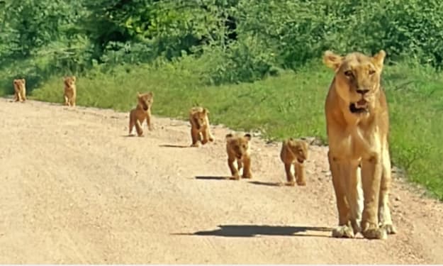
Tiny Lion Cubs Struggle To Keep Up With Mom
In the heart of the African savannah, life is a constant lesson for young animals. Few scenes are as endearing — or as heartwarming — as tiny lion cubs trying to keep pace with their mother. These little bundles of fur face a world full of challenges, from learning to hunt to avoiding dangers, all while depending on the guidance and protection of their experienced mom. Watching cubs wobble and tumble as they attempt to keep up with their mother reminds us that growing up, even in the wild, is a journey full of struggle, determination, and adorable missteps. The Early Days of Lion Cubs Lion cubs are born blind and helpless, usually in litters of two to six. For the first few weeks, they rely entirely on their mother for warmth, food, and safety. Even after opening their eyes and beginning to explore, the cubs are far from independent. The first months are crucial. Cubs learn social cues, hunting basics, and survival skills simply by watching their mother and the pride. But as anyone who has observed them knows, there’s often a huge gap between observation and action. Tiny cubs often struggle to match their mother’s pace, especially when she moves through long stretches of savannah or leads the family on patrols. A Mother’s Role in the Wild For a lioness, raising cubs is a full-time commitment. She hunts, defends her territory, and teaches her young, all while staying alert to predators such as hyenas, leopards, and even rival lions. The cubs, meanwhile, attempt to mimic her every move — often with clumsy yet charming results. A mother lion’s patience is remarkable; she frequently slows down, nudges them along, or stops to ensure no cub is left behind. These moments, while stressful for the tiny cubs, are vital learning opportunities. Struggling to Keep Up: Why It’s So Hard There are several reasons why tiny lion cubs have trouble keeping pace with their mother: Short Legs, Big Steps: Lion cubs’ legs are tiny and their coordination is limited, making it difficult to cover the same distance as an adult lioness. Curiosity: Cubs are naturally curious. A single butterfly or rustling bush can distract them, leaving mom to pause repeatedly. Energy Levels: Young lions tire quickly. Even with frequent naps, the cubs’ stamina is far lower than their mother’s. Learning Through Play: Play is not just fun; it teaches hunting, balance, and social skills. Running off to pounce on a sibling or chase an insect is all part of their education. Despite these challenges, the cubs’ determination to keep up demonstrates their resilience and growing understanding of the wild world. Lessons in Teamwork and Survival Every cub struggling to keep up is also learning crucial survival skills. The journey across the savannah is more than a test of speed — it’s a lesson in: Coordination: Cubs learn how to move efficiently across different terrains. Patience: They begin to understand the rhythms of adult life and the pace required for survival. Social Skills: Staying with the group teaches cubs how to interact with siblings and the pride, which is essential for their future roles. Observation: By following their mother, cubs study hunting techniques, territorial behavior, and predator awareness. Even the moments when cubs stumble or lag behind are essential for their development. These experiences prepare them for independence, which comes sooner than many might expect. The Cutest Moments in the Wild Anyone who has watched tiny lion cubs knows that their struggles are often irresistibly cute. Video clips from wildlife reserves frequently show cubs toddling along, tumbling over each other, or getting distracted mid-step. Observers often comment that these little stumbles reveal personality, determination, and playfulness, making them one of nature’s most heartwarming spectacles. While their mother is serious and focused, the cubs inject a sense of humor and lightness into life on the savannah. Why This Matters The struggles of lion cubs aren’t just adorable — they’re vital for understanding wildlife behavior. Conservationists and animal behaviorists use these moments to study growth patterns, social structures, and survival strategies in lion populations. These observations also highlight the importance of preserving natural habitats. Cubs must learn in a safe environment to survive; habitat loss, poaching, and climate change make these early struggles even more dangerous. Protecting the African savannah ensures that future generations of lions can experience the same lessons and playful tumbles. The Road to Independence Within a year, these tiny cubs will be more agile, faster, and more confident. By the time they reach two to three years old, males may begin to leave the pride, while females often stay and become caretakers themselves. Every misstep, tumble, and lagging moment is part of the journey toward strength, coordination, and independence. Watching them now gives us a glimpse of the challenges they will overcome, and the survival skills they will carry for life. A Celebration of Motherhood Ultimately, these scenes remind us of the incredible bond between mother and cubs. Her patience, vigilance, and teaching are the foundations of their future. The cubs’ struggles highlight the trials of growing up, while their determination showcases the resilience and beauty of wildlife. For those observing, it’s a powerful lesson in care, guidance, and perseverance, not just in lions but in the natural world as a whole. Final Thoughts Watching tiny lion cubs try to keep up with their mother is both entertaining and enlightening. It’s a story of growth, struggle, and resilience — a reminder that even the fiercest creatures start small, learning step by step. These little lions capture hearts while teaching life lessons: patience, determination, teamwork, and the importance of guidance. As they tumble and waddle across the savannah, they show us that growth is a process, one adorable misstep at a time. For wildlife enthusiasts, animal lovers, and anyone enchanted by nature, these tiny cubs are proof that even in the wild, love, care, and persistence are universal truths.
By Aarif Lashari2 days ago in Earth
Microbiota, microbiome or microflora: how to speak correctly and why it is for health.
You've probably heard the phrase, "We are what we eat." But modern science says more precisely: we are also those who live in us. Until 2016, it was believed that there are many times more bacteria in our body than our own cells. The latest calculations by mathematicians show that we divide the body with our microorganisms by about 50/50: about 30 trillion of our cells versus 38 trillion bacterial ones.
By Yaroslav Gorohov6 days ago in Earth


Comments
There are no comments for this story
Be the first to respond and start the conversation.