
The Hector Cloud
"For I See the Clouds for What They Are"


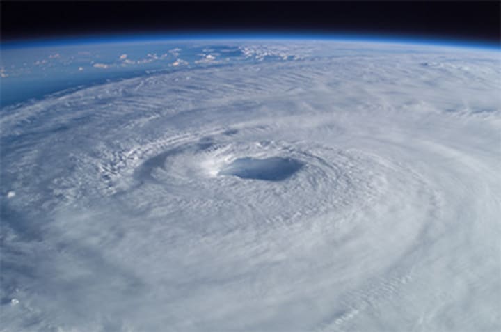
The Northern Territory of Australia is home to a truly bizarre and awe-inspiring phenomenon that takes place every year between September and March, captivating both locals and visitors alike. Each day, right around 3:00 in the afternoon, a massive thundercloud forms near the Tiwi Islands, and this mysterious cloud has earned a legendary reputation. Locals have affectionately named it Hector, or more colloquially, "Hector the Convector." While it may seem like just another thunderstorm at first glance, Hector has earned a unique place in both meteorological study and the culture of the region.

Hector the Convector, as it’s now known, it isn't just your average thundercloud. Its consistent appearance, occurring daily without fail, has turned it into a natural phenomenon that is as predictable as it is mysterious. The cloud itself is massive so large, in fact, that it has historically served as a key reference point for pilots and sailors who navigated the surrounding waters. Before modern weather radar systems, Hector was an essential tool in the skies and seas, providing a clear and visible signal of weather patterns in the area.

The formation of this giant cloud is a result of a unique interaction between sea breezes and the topography of the Tiwi Islands. During the afternoon hours, the land heats up quickly, and the cooler sea breezes from the surrounding ocean rush inland. As the moist, cool air meets the warm air rising from the land, it creates the perfect conditions for the formation of a towering convective cloud. The geography of the islands combined with these temperature differences amplifies the storm's development, giving Hector its signature appearance.
Despite understanding the basic mechanisms behind Hector’s formation, much about this giant, daily thundercloud remains a mystery. Meteorologists have studied Hector extensively, yet there are still many unanswered questions surrounding the exact dynamics of how and why it forms so consistently each afternoon. The interaction of sea breezes with the island's landscape seems to be a key factor, but the exact conditions required to create the perfect storm are still not fully understood. Research into the cloud’s behavior continues to reveal intriguing details, but scientists are far from unraveling all the secrets hidden within this remarkable phenomenon.
In addition to its meteorological importance, Hector the Convector has also become somewhat of a cultural icon in the Northern Territory. Its daily arrival brings a sense of rhythm to life in the region, serving as a reminder of nature’s powerful, unpredictable beauty. For many in the area, it’s a sign that the weather is changing, and it marks the transition from the hot, dry afternoon into the cooling evening.
Hector is also a key subject of intense meteorological study, as understanding its behavior can provide valuable insights into weather patterns and climate dynamics in the tropics. Researchers hope that further study of Hector will offer more information on convective weather systems, which play a crucial role in global weather patterns. By studying this single phenomenon, scientists could gain valuable knowledge on how clouds form, develop, and dissipate in tropical and subtropical regions around the world.
The future of research into Hector is promising. With advancements in satellite technology, weather radar, and atmospheric modeling, it is likely that we will soon uncover more details about this remarkable cloud and its behavior. Meteorologists are particularly interested in learning more about how Hector interacts with larger weather systems, such as tropical cyclones, which can have significant impacts on the Northern Territory. By gaining a deeper understanding of Hector the Convector, scientists may be able to predict similar weather patterns in other parts of the world, improving weather forecasting and our understanding of climate systems.
Moreover, the sheer regularity of Hector’s appearance has made it an object of fascination for weather enthusiasts, tourists, and even photographers who flock to the Northern Territory to witness this phenomenon. The cloud has become an integral part of the landscape, and its presence is now almost as iconic as the stunning natural beauty of the Tiwi Islands themselves. As Hector continues to form each afternoon, it reminds us of the incredible forces of nature at work forces that are both predictable and mysterious, serving as a testament to the complexity of the world around us.
In the future, we may come to know Hector in ways we’ve never imagined. New technologies and research methods could unlock hidden patterns or reveal even more fascinating aspects of this extraordinary cloud. Until then, Hector the Convector will remain a symbol of nature’s wonder, both in the Northern Territory and in the annals of meteorological study.
About the Creator
Cai Fox
I write to capture unspoken emotions, timeless love, lingering fear, and inner battles through true crime, poetry, & deep dives, I aim to connect, inspire & provoke thought. Join me in exploring the unique mind
https://beacons.ai/caidenjayce
The Man Who Dreamed in Reverse
The first time it happened, Graham dismissed it as Deja Vu. A strangely vivid dream of walking down Main Street, past the old bookstore, where a woman in a red coat would drop her coffee. The next afternoon, it unfolded exactly as he had seen it.
By Cai FoxExclusive • 11 months ago
Face to Face with Creatures of the Deep
Asia The Maldives At the Maldives you can enjoy the wonder of whale sharks, the largest fish in the ocean. These gentle giants swim among coral reefs of the Maldives archipelago, which has the world’s largest population of whale sharks. You can swim alongside these creatures from May to December, during the southwest monsoon season when plankton blooms and attracts the whale sharks.
By Rasma Raisters3 days ago in Earth


Comments
There are no comments for this story
Be the first to respond and start the conversation.