
Storm Timeline: When Snow Is Forecast to Start and End in the Pittsburgh Area
A comprehensive guide to the approaching winter storm — what to expect, when snow will begin, peak, and taper off in Pittsburgh and surrounding communities.

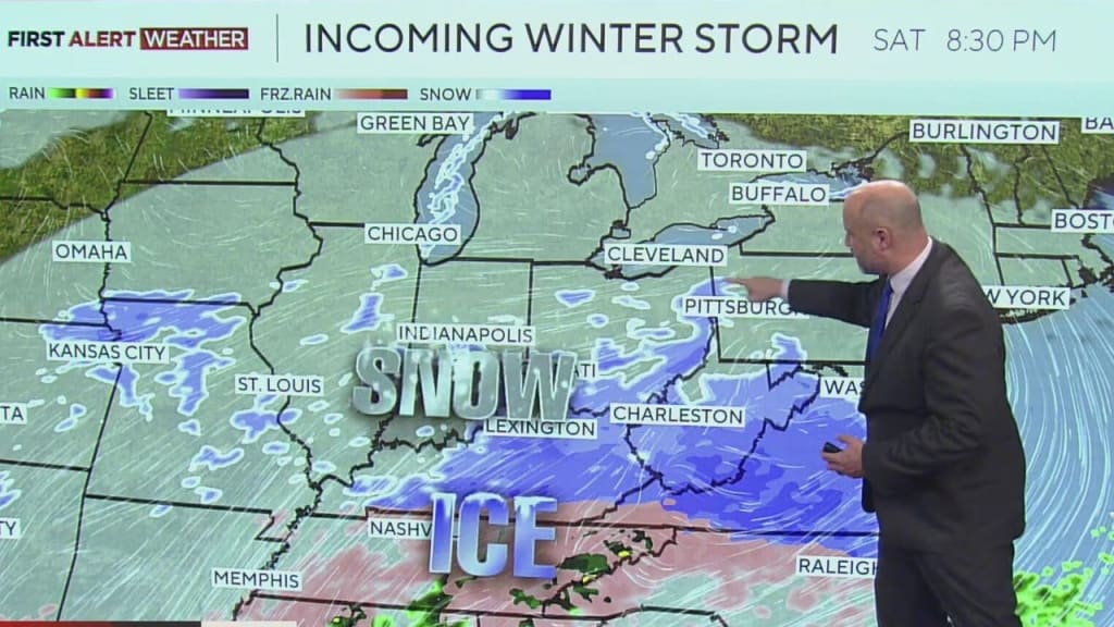
Pittsburgh residents are bracing for a major winter storm expected to bring significant snowfall, hazardous driving conditions, and potential power disruptions over the weekend. Local authorities have issued a winter storm warning, warning communities to prepare for what could be 8–14 inches of snow or more. The storm is set to impact the region for more than 24 hours, starting late Saturday night and continuing into Monday morning.
Understanding when the snow will start, when it will peak, and when it will end can help residents plan travel, work, school, and community activities safely. Here is a detailed timeline of the storm and what Pittsburghers need to know.
Saturday Afternoon: Cold Air Moves In
Before the snow even begins, bitterly cold air is moving into western Pennsylvania on Saturday afternoon. Temperatures will drop into the teens and low twenties, creating conditions that allow snow to stick almost immediately once precipitation begins. Residents are encouraged to finish errands, stock up on essentials, and prepare vehicles before the evening.
By late Saturday afternoon, roads will remain clear, but the stage is being set for the snow to arrive. Experts warn that even brief travel delays now could compound later, once accumulation begins.
Late Saturday Night (7–10 p.m.): First Snow Flakes Arrive
The first snowflakes are expected to fall between 7 p.m. and 10 p.m. on Saturday, marking the official start of the winter storm. Initially, the snowfall will be light, with accumulation slow to develop.
During this period:
Southern suburbs around Pittsburgh may see snow first, gradually spreading across the city and surrounding counties.
Roads will begin to turn white, though hazards are expected to be minor at first.
By midnight, some areas could have 1–2 inches of accumulation.
Even this initial snow is enough to make travel slippery, especially on untreated roads, bridges, and overpasses. Residents should limit unnecessary travel after the first flurries appear.
Sunday Morning (5–11 a.m.): Snow Intensifies
Sunday morning is when the storm begins to pick up momentum. Widespread snowfall will develop across Pittsburgh and the surrounding metro area. By 5 a.m., snow is expected to become continuous and heavier, marking the start of the period when travel will become increasingly hazardous.
Key points for Sunday morning:
7 a.m. to 11 a.m.: Snowfall rates may reach 1–2 inches per hour, quickly covering roads and sidewalks.
Visibility may drop significantly during peak snowfall, making early commutes risky.
By mid-morning, accumulation in most areas could reach 3–5 inches.
Schools and local businesses should anticipate delays, and residents are encouraged to stay updated on road conditions and public transportation announcements.
Sunday Afternoon to Evening: Peak Snowfall
The heaviest snow is expected Sunday afternoon into early evening, when accumulation rates will be at their highest. Meteorologists predict Pittsburgh could see 6–12 inches by mid-afternoon, with some northern and western suburbs possibly exceeding 14 inches.
During this peak:
Driving conditions will become very dangerous, with snow-covered roads, limited visibility, and slick surfaces.
Emergency services advise avoiding nonessential travel.
Power outages may occur as heavy snow accumulates on tree branches and power lines.
This is also the period when the storm is most likely to cause community disruptions, including school closures, canceled events, and delays in public services. Residents should remain indoors if possible and ensure they have necessary supplies like food, water, and batteries.
Sunday Night (7 p.m. – Midnight): Snow Gradually Eases
By Sunday evening, the storm begins to lose strength, though snow will continue at a lighter intensity. Accumulation totals will still climb slowly as snow showers persist into the night.
Roads may remain treacherous overnight, particularly untreated side streets and rural areas.
Many areas could have 10–14 inches or more of total accumulation by midnight.
Residents should avoid late-night travel if possible and keep vehicles and driveways cleared to prevent ice buildup.
Monday Morning: Lingering Snow Showers
The storm is expected to taper off Monday morning, though occasional snow showers may persist in parts of the region. By midday Monday, the National Weather Service expects the snow to largely end, signaling the conclusion of the major winter storm.
Even after the storm ends:
Residual ice and snow will continue to make roads slippery.
Subzero wind chills are expected, adding a layer of danger for those venturing outside.
Cleanup and snow removal efforts may extend into Monday afternoon for businesses and municipalities.
Preparing for the Storm: Safety Tips
Residents are encouraged to prepare in advance for the full impact of the storm:
1. Limit travel: Avoid driving during peak snowfall Sunday afternoon.
2. Stock up on essentials: Food, water, medications, and heating supplies.
3. Check heating systems: Ensure furnaces and space heaters are functioning safely.
4. Plan for school or work closures: Stay updated with local news and school district announcements.
5. Clear snow safely: Shovel sidewalks and driveways regularly to prevent icy buildup.
Community members are also urged to check on neighbors, especially the elderly and vulnerable, as heavy snow and cold can create dangerous living conditions.
Conclusion
The Pittsburgh area is entering a significant winter weather event with snowfall starting late Saturday night, peaking Sunday afternoon, and gradually tapering Monday morning. With accumulation totals potentially reaching 14 inches or more, residents should plan ahead, limit travel during peak snow, and take safety precautions to protect themselves, their families, and their communities.
This storm is more than just a weather event — it’s a reminder of the importance of community preparedness, awareness, and looking out for one another during extreme conditions. Staying informed, following local advisories, and acting proactively will help Pittsburgh navigate this storm safely.
About the Creator
Asad Ali
I'm Asad Ali, a passionate blogger with 3 years of experience creating engaging and informative content across various niches. I specialize in crafting SEO-friendly articles that drive traffic and deliver value to readers.
USA vs Iran: A Military Mismatch in 2026
Comparing the U.S. and Iranian militaries is not about who would win a fair fight. It's about understanding two completely different ways of thinking about war. By 2026, the gap between their traditional strength will be wider than ever. The U.S. is a global superpower built to fight and win anywhere. Iran is a regional survivor, built to make an invasion so painful that no one would ever try.
By LegacyWords7 days ago in Earth
The Growing Need for Air Purification and Air Purifiers Today
Introduction Air is the most basic necessity for life, yet it is often the most overlooked factor when discussing health, productivity, and quality of living. While people pay close attention to the food they eat and the water they drink, the air they breathe — especially indoors — rarely receives the same level of scrutiny. In today’s world, however, this mindset is rapidly changing. Rising pollution levels, climate change, urbanisation, industrial growth, and the lingering effects of global health crises have brought air quality to the forefront of public awareness.
By Hafsa Usmani3 days ago in Earth
Rage
Content Warning: Domestic Violence, Assault Rage D. A. Ratliff “Who did this?” My voice echoed through the house. All I wanted was a cup of tea, but one of the twins, running through the house like maniacs, knocked it over. My nerves tingled, and every muscle in my body felt coiled like a spring. Survival seemed out of reach.
By D. A. Ratliff5 days ago in Fiction


Comments
There are no comments for this story
Be the first to respond and start the conversation.