
Rain from Hurricane Helene's Remnants Expected in Pittsburgh Early Next Week
"Unseasonably Warm Weekend Followed by Rain Showers as Hurricane Helene’s Remnants Pass Through Pittsburgh"
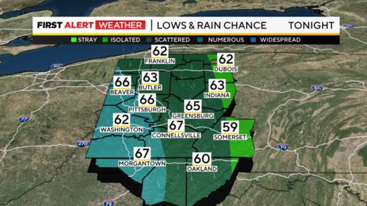
PITTSBURGH (KDKA)– As we head into the weekend, Pittsburgh is experiencing unusually warm temperatures for late September. Saturday morning started off with most places in the mid to upper 60s, and Pittsburgh itself is hovering around 70 degrees, which is much warmer than normal for this time of year. Typically, late September should see high temperatures closer to the mid-60s, so this warm spell has been noticeable.
While today started off on the warmer side, a few showers are expected throughout the morning, especially for areas from Pittsburgh and northward toward Highway 422 and Interstate 80. However, there’s good news for those in the southern and southeastern parts of the region. A patch of dry air is moving in, which should lead to some sunshine breaking through during the late morning and early afternoon hours, giving us a brief break from the rain.
Warm Temperatures Continue
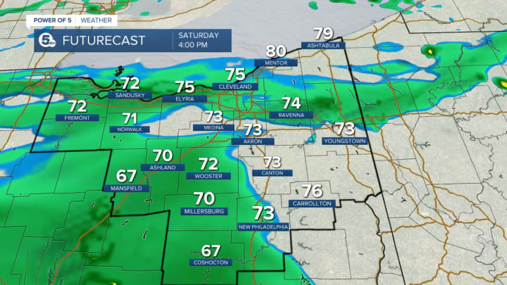
Despite the showers, the temperatures will remain mild today. In Northwest Pennsylvania, highs are expected to reach the mid-70s, while Pittsburgh and areas south into Northern West Virginia and Northwest Maryland could see temperatures climbing to around 80 degrees. It’s quite a bit warmer than what we’d usually expect at this time of year, making it feel more like late summer than early fall.
Hurricane Helene’s Remnants Moving In
The remnants of Hurricane Helene, which recently caused catastrophic flooding in the Carolinas and Tennessee, are now merging with an upper-level low-pressure system over the Lower Ohio River Valley. This system is making its way towards Pittsburgh and will bring some unsettled weather by the end of the weekend.
Starting on Saturday evening and lasting into early next week, the remnants of Hurricane Helene will bring clouds and rain showers to our area. Rain will become more widespread on Sunday and Monday, with showers expected to continue through Tuesday morning. Fortunately, while it will be rainy, we aren’t expecting the kind of heavy downpours that led to the flooding in the southern states. Most areas will see around half an inch of rain, although there could be slightly higher amounts in parts of northern West Virginia.
No Flooding Expected
The good news is that flooding is not expected in Pittsburgh or the surrounding areas. Even though the remnants of Hurricane Helene are bringing rain, a lot of dry air has mixed into the system. This dry air will prevent the kind of intense rainfall that would typically cause flooding. Instead, we’ll see numerous, but lighter, showers across the region. The rain might be steady at times, but it should stay manageable.
A Mild Week Ahead
Temperatures will stay slightly above average for the next several days, with little variation between daytime highs and overnight lows. Expect daytime highs to remain in the upper 60s to low 70s, with overnight lows not dropping much below the mid-60s. It’s going to feel mild and comfortable, even as the rain moves through.
Looking ahead to the rest of the week, a cold front is expected to arrive between Tuesday and Wednesday. This front will bring a brief shot of cooler temperatures, giving us a taste of the fall weather we’ve been waiting for. However, this cool spell won’t last long. By the end of next week, temperatures are expected to rise once again to above-normal levels, so it looks like we’ll be bouncing back to warmer weather soon after the cool front passes.
Staying Prepared
While we aren’t expecting any major storms or flooding in Pittsburgh, it’s still a good idea to keep an eye on the weather as the remnants of Hurricane Helene move through. Be prepared for some rain and possible delays if you’re traveling or have outdoor plans on Sunday or Monday.
For those heading out today, enjoy the warmer-than-usual temperatures and take advantage of any sunny breaks, especially if you’re in the southern or southeastern parts of the region. But keep an umbrella handy, as some areas will still see those light showers through the day.
Looking forward to early next week, it’s going to be a rainy start, but the good news is that we aren’t expecting any severe weather. And after the brief shot of cooler air midweek, the warmth of late September looks like it will make a return.
In summary, Pittsburgh will see rain from the remnants of Hurricane Helene, but flooding isn’t a concern, and temperatures will stay mild for the next several days. The rain is likely to clear up by Tuesday, with cooler temperatures briefly moving in before we warm up again later in the week. So, while you might need your raincoat this weekend, it won’t be long before we’re back to enjoying unseasonably warm weather once more.
About the Creator
Scientists Probe How Long-Term Spaceflight Alters Immunity
On Earth, a human body with a properly functioning immune system will work to overcome an infection. But in space, that same immune system will have to work a bit harder to overcome the same infection. In the isolated environment of the International Space Station, many factors — physiological stress, disrupted circadian rhythms, radiation, microgravity, and other spaceflight factors — can alter an astronaut’s immune response.
By Voice of Reality6 days ago in Earth


Comments
There are no comments for this story
Be the first to respond and start the conversation.