
Exploring the Impact and Potential of Geostationary Earth Orbit (GEO) Satellites
Science

 Satellites")
In the vast expanse of space, amidst the myriad of celestial bodies, orbits, and cosmic phenomena, lies an area of paramount importance to modern civilization: Geostationary Earth Orbit (GEO). GEO is a unique zone approximately 35,786 kilometers (22,236 miles) above Earth's equator where satellites can maintain a fixed position relative to the planet's surface. This stationary characteristic makes GEO satellites invaluable for a wide array of applications, ranging from telecommunications and broadcasting to weather monitoring and navigation.
Understanding GEO Satellites:
GEO satellites, as the name suggests, orbit the Earth at the same rate as the planet's rotation. This synchronization enables them to appear stationary when observed from the ground, making them ideal platforms for services that require continuous coverage over a specific geographic area. Unlike Low Earth Orbit (LEO) satellites, which orbit closer to the Earth's surface and traverse the planet rapidly, GEO satellites maintain a consistent position relative to the ground below.
These satellites typically orbit at an altitude of around 35,786 kilometers, where their orbital period matches Earth's rotational period. As a result, they remain fixed relative to a specific point on the planet's surface, making them ideal for applications requiring constant communication links or persistent observation capabilities.
Applications of GEO Satellites:
Telecommunications: One of the most prominent uses of GEO satellites is in telecommunications. They facilitate long-distance communication by relaying signals between ground stations, enabling global connectivity for various purposes, including television broadcasting, internet services, and long-distance telephone calls. Companies like Intelsat, SES, and Eutelsat operate fleets of GEO satellites to provide these critical communication services worldwide.
Broadcasting: GEO satellites play a crucial role in broadcasting television and radio signals to large geographic regions. Broadcasting companies utilize GEO satellites to transmit their programming to terrestrial stations or directly to consumer satellite dishes, ensuring widespread access to entertainment, news, and educational content.
Weather Monitoring and Earth Observation: GEO satellites equipped with advanced sensors and imaging systems contribute significantly to weather forecasting, environmental monitoring, and disaster management. They provide continuous coverage of the Earth's surface, allowing meteorologists to track weather patterns, monitor environmental changes, and assess the impact of natural disasters in real-time.
Navigation and Positioning: While the Global Positioning System (GPS) primarily relies on a constellation of LEO satellites, GEO satellites also play a role in augmenting navigation and positioning services. Geostationary satellites broadcast supplementary signals that improve the accuracy and reliability of GPS-based navigation systems, particularly in regions where LEO satellite visibility may be limited.
Military and Defense: Governments around the world leverage GEO satellites for military and defense purposes, including reconnaissance, surveillance, and secure communication. These satellites provide vital intelligence gathering capabilities and enable secure communication channels for military operations conducted on land, at sea, and in the air.
Challenges and Future Developments:
While GEO satellites offer numerous benefits, they also face certain challenges and limitations. One of the primary challenges is the limited spectrum availability, especially in congested orbital slots where multiple satellites operate in close proximity. This spectrum scarcity can lead to interference issues and capacity constraints, affecting the quality and reliability of communication services.
Additionally, the high altitude of GEO orbits results in higher signal propagation delays, known as latency, which can impact real-time communication applications such as voice calls and online gaming. Efforts to mitigate latency through technological advancements, such as the deployment of High Throughput Satellites (HTS) and Low Earth Orbit (LEO) satellite constellations, are underway to address this challenge.
Looking ahead, the future of GEO satellites holds promising developments driven by advancements in satellite technology, including improved propulsion systems, higher throughput capabilities, and enhanced onboard processing. These innovations will enable GEO satellites to offer higher data rates, greater bandwidth efficiency, and expanded service coverage, further enhancing their utility across various sectors.
Conclusion:
Geostationary Earth Orbit (GEO) satellites represent a cornerstone of modern telecommunications, broadcasting, weather monitoring, and navigation systems. Their unique ability to maintain a fixed position relative to the Earth's surface makes them indispensable for applications requiring continuous coverage over specific geographic regions. Despite facing challenges such as spectrum scarcity and latency issues, ongoing technological advancements promise to enhance the capabilities and effectiveness of GEO satellites in the years to come. As humanity continues to rely on satellite-based services for communication, observation, and navigation, the role of GEO satellites will remain pivotal in shaping the future of connectivity and information exchange on a global scale
About the Creator
Samson E. Gifted
SEG, is a talented writer, editor, and publisher known for his exceptional storytelling and keen eye for detail. With a passion for words and a commitment to excellence earning a reputation as a respected figure in the publishing industry.
Keep reading
More stories from Samson E. Gifted and writers in Earth and other communities.
Unraveling the Mysteries of Science
Science, with its boundless curiosity and relentless pursuit of truth, stands as humanity's most formidable tool for understanding the world around us. From the minute intricacies of subatomic particles to the expansive reaches of the cosmos, science encompasses a vast spectrum of knowledge waiting to be explored. In this article, we embark on a journey through the realms of scientific inquiry, delving into its significance, methodologies, and the profound impact it has on our lives.
By Samson E. Gifted2 years ago in Earth
The Reality of the Illusion of Time
Recently, as I strolled along the short stretch to my strength training session, I aimlessly took in the row of tatty shops and shabby buildings along the route and passed an off-street, in which one of my sisters used to live, around thirteen years ago.
By Chantal Christie Weiss4 days ago in Earth
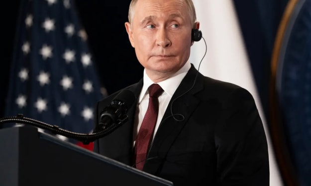
Why Putin Went Quiet When Challenged by Trump Over Venezuela
When U.S. forces captured Venezuelan President Nicolás Maduro in early January 2026, the world was stunned. Venezuela has long been a Russian ally, yet Russian President Vladimir Putin remained almost completely silent when challenged directly by U.S. President Donald Trump. Why would a leader so often outspoken on the world stage hold back in such a dramatic moment? Let’s unpack the story and explore what it means for global politics. A Bold Move That Shocked the World On January 3, U.S. forces executed a daring operation in Venezuela, taking Maduro into custody in New York to face charges including drug trafficking and narco‑terrorism. The operation was framed by the U.S. as a step to enforce justice, but critics saw it as an extraordinary overreach of power. Venezuela is no ordinary country for Russia. Since the days of Hugo Chávez, Moscow has cultivated close ties with Caracas, offering military support, energy deals, and diplomatic backing on the global stage. Past actions included Russian bombers visiting Venezuela and high-profile defense agreements. Given this history, many expected a fiery response from Putin. Yet, the Kremlin remained calm, issuing measured statements rather than sharp threats. Why Silence Was Strategic Experts suggest there are several reasons for Putin’s muted reaction, each revealing the careful calculation behind the Kremlin’s foreign policy. 1. Focus on the War in Ukraine Russia’s primary priority remains Ukraine. Engaged in a high-stakes military and diplomatic battle, Putin cannot afford distractions or new confrontations far from home. Escalating tensions with the United States over Venezuela could jeopardize Moscow’s position in Europe. A New York Times report highlighted that Russia is “subordinating all other interests to the war in Ukraine,” suggesting that even a high-profile ally like Venezuela takes a back seat to Moscow’s strategic goals. 2. Limited Military Options While Russia’s alliance with Venezuela is longstanding, much of the support has been symbolic rather than operational. Defense systems and military cooperation exist on paper, but Russia lacks the immediate ability to counter a U.S. operation thousands of miles away. Putin may have recognized that responding aggressively would be both ineffective and costly, potentially risking military and economic consequences that Moscow cannot afford. 3. Maintaining Diplomatic Channels with Washington With Donald Trump back in the White House since 2025, there has been cautious optimism in Moscow about recalibrating U.S.–Russia relations. Avoiding a dramatic confrontation over Venezuela keeps diplomatic channels open, allowing Russia to negotiate on other high-priority issues like Ukraine and sanctions relief. In other words, silence can be a calculated strategy, signaling restraint rather than weakness. 4. Russia’s Global Influence Is Waning The Maduro episode also highlights a broader geopolitical reality: Russia’s global reach has limits. Since the 2022 invasion of Ukraine, Moscow’s influence in regions like the Middle East and parts of the former Soviet Union has weakened. Venezuela remains one of its few high-profile allies outside Europe, but even there, Russia’s power is largely symbolic. By not escalating, Putin is acknowledging a practical truth: Russia cannot be everywhere at once, and some battles are not worth fighting. 5. Choosing Battles Wisely Some analysts emphasize that Putin’s quiet response is more about strategic prioritization than capitulation. In a world dominated by nuclear powers and volatile global politics, direct confrontation with the United States over Venezuela could spiral into a far larger crisis. By staying silent, the Kremlin may be signaling that it picks its battles carefully, focusing resources on Ukraine, where the stakes are highest. What This Means for the World Putin’s silence sends several messages: Russia is currently stretched, economically and militarily. Moscow is prioritizing Ukraine over symbolic allies. Strategic restraint is sometimes more powerful than public confrontation. The limits of Russian influence are becoming more visible to the world. This episode reflects a new reality in geopolitics: power is as much about choosing when not to act as when to assert force. The Bigger Picture The capture of Maduro is a defining moment not just for Venezuela, but for global politics. It shows the United States asserting power in a way not seen for decades, while Russia’s quiet reaction underscores its current limits and priorities. For observers, Putin’s silence is a lesson in modern geopolitics: even the most assertive leaders exercise restraint when stakes are high and risks are global. In the end, the Maduro affair reminds us that in today’s world, the loudest response is not always the most effective one — sometimes, quiet calculation speaks volumes. Sources and Further Reading The US capture of Maduro reveals Russia’s weakness – Atlantic Council ‘It sends a horrible signal’: US politicians react to capture of Nicolás Maduro – The Guardian Russia slams 'neocolonial threats' against Venezuela – Reuters
By Muhammad Hassan7 days ago in Earth


Comments
There are no comments for this story
Be the first to respond and start the conversation.