
Alaska Tsunami: Causes, History, and Preparedness
Exploring Alaska’s Risk of Tsunamis and How Communities Can Stay Safe

Alaska, known for its breathtaking landscapes and icy wilderness, is also one of the most tsunami-prone regions in the United States. Due to its location along the seismically active Pacific "Ring of Fire," Alaska has experienced some of the most destructive tsunamis in North American history. This article delves into the science behind Alaska tsunamis, notable historical events, and how residents and authorities work to prepare for future threats.
The Science Behind Alaska’s Tsunamis
Tsunamis in Alaska are primarily triggered by undersea earthquakes, often resulting from the movement of tectonic plates along subduction zones. Alaska lies at the boundary where the Pacific Plate dives beneath the North American Plate. This geological activity causes frequent earthquakes, some of which generate powerful tsunamis.
In addition to seismic events, tsunamis in Alaska can also be triggered by underwater landslides or glacial calving events—where large chunks of ice break off into the ocean. These localized events can produce devastating waves in narrow bays and fjords with little warning.
The 1964 Good Friday Earthquake and Tsunami
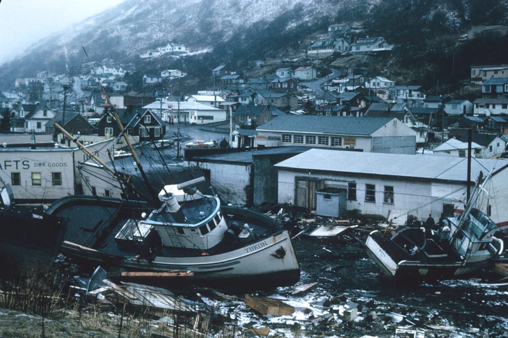
One of the most catastrophic natural disasters in Alaskan—and American—history occurred on March 27, 1964. A magnitude 9.2 earthquake, the second-largest ever recorded worldwide, struck Prince William Sound. It unleashed a massive tsunami that wreaked havoc across coastal Alaska, particularly in communities like Valdez, Seward, and Kodiak.
The waves also traveled across the Pacific Ocean, causing damage and fatalities as far away as Hawaii and California. In Alaska alone, the tsunami caused 106 of the 131 total deaths associated with the earthquake. Entire neighborhoods were swept away, ports were destroyed, and infrastructure damage was estimated at over $300 million (equivalent to billions today).
This tragic event reshaped how tsunamis are understood and led to significant improvements in tsunami warning systems and emergency preparedness nationwide.
Modern Monitoring and Warning Systems
Since the 1964 disaster, Alaska has significantly upgraded its tsunami preparedness infrastructure. The National Tsunami Warning Center (NTWC), based in Palmer, Alaska, plays a crucial role in monitoring seismic activity and issuing warnings to coastal areas. When an earthquake occurs, NTWC quickly assesses the potential for tsunami generation using data from seismic networks and ocean buoys.
If a tsunami is likely, the center issues bulletins to state and local agencies, which activate warning sirens and emergency broadcast systems. Public safety announcements are sent via TV, radio, and mobile alerts, giving residents crucial time to evacuate.
Alaska's Unique Risks: Landslide-Generated Tsunamis
While tectonic earthquakes are the primary source of tsunamis in Alaska, the state also faces unique risks from glacial and landslide activity. A notable example is the 1958 Lituya Bay mega-tsunami. A massive landslide triggered by an earthquake fell into the bay, displacing a staggering volume of water and generating a wave over 1,700 feet high—the tallest tsunami ever recorded.
Although this event occurred in a remote area with minimal human impact, it highlighted the potential for hyper-localized but incredibly powerful tsunamis in Alaska’s glacial regions.
Preparedness in Alaska’s Coastal Communities
Many of Alaska’s coastal communities are small, remote, and vulnerable. Preparedness involves both community planning and public education. Residents are encouraged to:
Know evacuation routes and safe zones.
Keep emergency kits ready.
Practice tsunami drills.
Stay informed through NOAA alerts and local emergency services.
Some towns, like Seward and Kodiak, have clearly marked tsunami evacuation signs and designated high ground shelters. Schools often incorporate disaster education into their curriculum to ensure children understand how to respond in an emergency.
The Role of Climate Change
As climate change accelerates glacial melting, it increases the risk of landslide-induced tsunamis in fjords and bays. Melting permafrost can destabilize steep slopes, and increased rainfall contributes to erosion. These environmental changes make real-time monitoring even more critical.
Scientists and agencies are using satellite data, drone surveillance, and AI-based modeling to better predict potential landslide sites and assess their tsunami potential.
Conclusion
Alaska’s majestic coastline masks a serious natural threat: tsunamis. With a history shaped by massive waves and earth-shaking quakes, Alaska has learned painful lessons about the power of nature. Yet, through science, education, and community resilience, the state continues to lead the way in tsunami preparedness. Staying informed and prepared can make all the difference in protecting lives when the next wave hits.
About the Creator
Asad Ali
I'm Asad Ali, a passionate blogger with 3 years of experience creating engaging and informative content across various niches. I specialize in crafting SEO-friendly articles that drive traffic and deliver value to readers.
Skiing Photography: Capturing the Magic of Snow-Covered Landscapes on the Slopes
Winter mountains create a scene that feels calm, bright, and powerful at once. Snow spreads across the ground, trees, and mountain peaks like a natural blanket. The white surface reflects sunlight, making the entire area glow. Skiers moving through the snow add life and motion to this peaceful setting. This mix of nature and action attracts photographers from around the world. Skiing photography allows people to capture both adventure and beauty in one image.
By Neil Druker6 days ago in Earth


Comments
There are no comments for this story
Be the first to respond and start the conversation.