
Latest snow totals as winter storm slams Philadelphia region
Heavy snowfall and gusty winds blanket the Delaware Valley, disrupting travel, closing schools, and leaving communities digging out after one of the season’s most impactful storms.
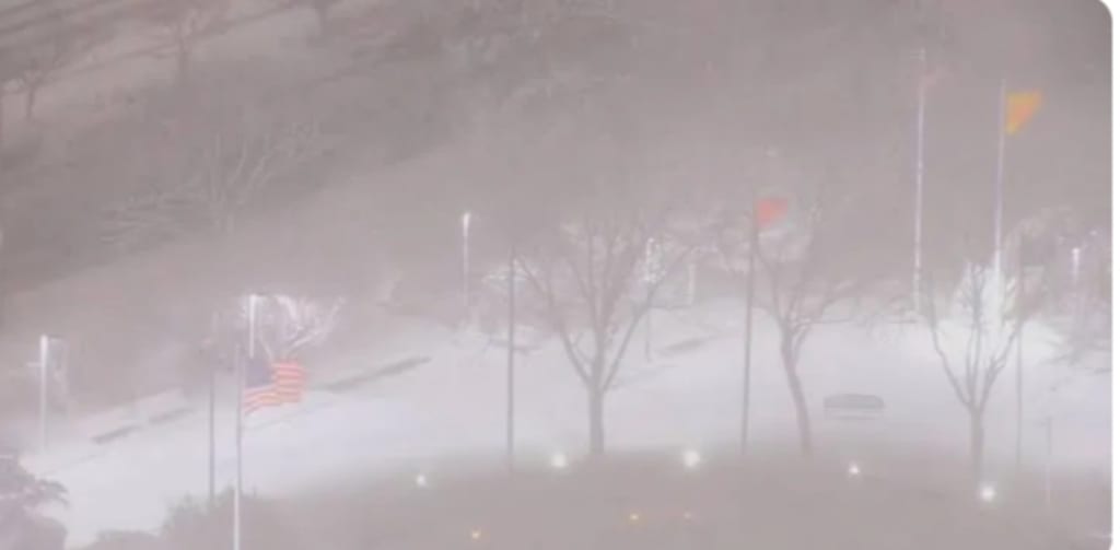
Heavy bands of snow, gusty winds, and plunging temperatures combined to hammer the Philadelphia region this week, creating hazardous travel conditions and leaving behind some of the highest snowfall totals the area has seen in recent winters. From Center City streets to the far reaches of the surrounding suburbs, residents woke up to snow-covered cars, icy sidewalks, and a steady hum of plows pushing through thick drifts.
Snowfall Totals Across the Region
Preliminary snowfall reports show a wide range of totals depending on location, elevation, and the intensity of localized snow bands. In Philadelphia proper, totals generally ranged between 6 and 9 inches, with some neighborhoods on the northern and western edges of the city reporting slightly higher amounts.
The heaviest snow appeared to fall in parts of Montgomery and Bucks counties, where several communities measured between 8 and 12 inches. In elevated areas northwest of the city, totals approached or exceeded a foot in isolated spots. Meanwhile, areas closer to the Delaware River and southern New Jersey saw slightly lower totals, typically between 4 and 7 inches, as occasional mixing and lighter precipitation cut into accumulations.
Meteorologists noted that mesoscale banding — narrow corridors of intense snowfall — played a major role in the uneven distribution. In neighborhoods caught under these bands, snowfall rates briefly reached 1 to 2 inches per hour, quickly overwhelming untreated roads and leading to rapid accumulation.
Timing and Impact
The storm began as light snow during the pre-dawn hours, gradually intensifying through the morning commute. By mid-morning, major roadways including Interstate 76 and I-95 were snow-covered, and traffic slowed to a crawl in many areas. Numerous minor accidents were reported as drivers struggled with slick pavement and reduced visibility.
Public transportation services experienced delays as well. Regional rail lines operated at reduced speeds, and some bus routes were temporarily suspended during the heaviest snowfall. Philadelphia International Airport reported flight delays and cancellations, with crews working continuously to clear runways and de-ice aircraft.
Snow tapered off by late afternoon, but blowing snow and dropping temperatures created additional challenges into the evening. Wind gusts of 25 to 35 mph caused drifting in open areas, particularly in suburbs and along highways.
School Closures and Remote Learning
As forecasts began to signal a significant snowfall event, many school districts across southeastern Pennsylvania preemptively announced closures or shifted to remote instruction. For students and families, the storm provided an unexpected snow day — though in some cases, virtual classrooms replaced sledding hills.
Local officials urged residents to stay off the roads unless absolutely necessary, emphasizing that plow crews needed space to operate efficiently. In Philadelphia, more than 400 pieces of snow removal equipment were deployed, focusing first on primary and secondary roads before turning attention to residential streets.
The Science Behind the Storm
This winter storm developed as a low-pressure system tracked along the Mid-Atlantic coastline, intensifying as it moved offshore. Cold air already in place across the region ensured that most precipitation fell as snow rather than rain.
Forecasters had highlighted the potential for a “coastal enhancement” effect, where moisture from the Atlantic fuels heavier snowfall closer to the coast. However, slight shifts in the storm’s track influenced exactly where the heaviest snow bands set up. A deviation of even 20 to 30 miles can dramatically alter accumulation totals in a region as densely populated as greater Philadelphia.
The storm also benefited from a strong upper-level disturbance, which enhanced lift in the atmosphere and supported periods of intense snowfall. As the system pulled away, cold high pressure built in behind it, locking in below-freezing temperatures and preventing rapid melting.
Digging Out: What Comes Next
With snow totals now finalized in many areas, attention has turned to cleanup and recovery. City crews are prioritizing clearing snow from emergency routes and public transit corridors. Residents are reminded that municipal regulations require sidewalks to be shoveled within a certain timeframe after snowfall ends.
Temperatures are expected to remain below freezing for much of the next 24 to 48 hours, which means untreated surfaces may remain icy. Black ice is a particular concern during overnight and early morning hours, when refreezing can occur even on roads that appear merely wet.
Homeowners are also being advised to clear snow from storm drains where possible to prevent localized flooding when melting begins. Though totals were not record-breaking, the combination of heavy, wet snow and gusty winds has placed stress on tree limbs and power lines. A small number of scattered power outages were reported in suburban communities, though utility providers indicated that most were restored quickly.
A Reminder of Winter’s Grip
While Philadelphia is no stranger to winter weather, significant snowstorms have become somewhat less frequent in recent years. This event serves as a reminder that the region remains vulnerable to impactful winter systems when atmospheric conditions align.
Longtime residents recall blockbuster storms that dropped well over a foot of snow, paralyzing the city for days. Compared to those historic blizzards, this week’s storm may fall short in sheer magnitude. Yet its timing — coinciding with busy work and school schedules — amplified its disruption.
For many, the storm also offered moments of beauty amid the inconvenience. Snow blanketed historic rowhomes, transformed city parks into white landscapes, and muffled the usual urban noise. Children bundled up to build snowmen, while neighbors helped push stuck vehicles and shovel shared sidewalks.
Looking Ahead
Forecasters are monitoring another potential system later in the week, though current indications suggest it will be weaker and may track farther offshore. Still, with winter far from over, additional snowfall remains possible in the coming weeks.
Residents are encouraged to restock winter supplies, check that snow shovels and ice melt are readily accessible, and remain attentive to updated forecasts. Even moderate storms can create outsized impacts in densely populated regions.
As plows continue their rounds and commuters navigate slushy intersections, the Philadelphia region settles into the aftermath of a classic Mid-Atlantic winter storm — one defined by shifting bands, steady accumulation, and the shared experience of digging out together.
About the Creator
A Gathering of Evil Bosses
“I’m the queen of chin jutting while I smooth my hair, attacking, insulting, and deflecting to protect my appointer.” “Oh, please, Blondi, my hair is curled, highlighted, and longer than yours. I feature television commercials telling immigrants that we will give them a free plane ride home, and if they voluntarily turn themselves in, they will be allowed to legally apply for re-entry. It runs everywhere, and I look good in it! You can’t compete because of your blond hair. Mine is nicer, and my lips are prettier than yours.”
By Andrea Corwin 6 days ago in The Swamp
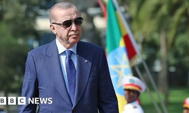
Turkey’s President Rejects Israel’s Recognition of Somaliland
Turkish President Recep Tayyip Erdogan has strongly rejected Israel’s reported move toward recognizing Somaliland, calling it a violation of international law and a dangerous step that could destabilize the Horn of Africa. Ankara reaffirmed its commitment to Somalia’s territorial integrity, signaling that Turkey will oppose any actions that undermine the sovereignty of the Somali state. Firm Diplomatic Response In a statement issued following a high-level cabinet meeting, Erdogan said that any recognition of Somaliland as an independent state would be “unacceptable and illegitimate.” He stressed that such a move contradicts long-standing international consensus supporting Somalia’s unity and risks fueling new political and security tensions in the region. “Somalia’s territorial integrity is not negotiable,” Erdogan said. “Unilateral recognition of Somaliland would deepen instability in an already fragile region and damage efforts aimed at achieving lasting peace and development.” Turkey’s Foreign Ministry echoed the president’s remarks, urging all countries to respect Somalia’s sovereignty and warning that recognition of breakaway regions sets a troubling precedent in global diplomacy. Background on Somaliland Somaliland declared independence from Somalia in 1991 following the collapse of the central government. Despite maintaining relative stability and its own governing institutions, Somaliland has not been internationally recognized as a sovereign state. The international community, including the United Nations, continues to view it as part of Somalia. Reports that Israel may be considering recognition of Somaliland have sparked controversy across Africa and the Middle East. Somali authorities have condemned the idea, while regional actors fear it could encourage further fragmentation and complicate diplomatic relations in the Horn of Africa. Turkey’s Strategic Interests Turkey has invested heavily in Somalia over the past decade, becoming one of the country’s closest international partners. Ankara has funded infrastructure projects, humanitarian aid programs, and military training initiatives for Somali security forces. Turkey also operates a major military training base in Mogadishu and plays a key role in supporting the Somali government’s fight against militant groups. Analysts say Turkey’s reaction reflects both diplomatic principles and strategic interests. “Ankara sees Somalia as a key partner in Africa,” said a regional expert. “Any move that weakens the Somali state directly affects Turkey’s political influence and long-term investments in the region.” Regional and International Implications Israel’s potential recognition of Somaliland could reshape alliances in the Horn of Africa. Supporters of Somaliland argue that international recognition would strengthen its institutions and promote stability. Critics, however, warn that it would provoke tensions with Somalia and possibly inflame regional rivalries involving Ethiopia, Djibouti, and other neighboring states. Turkey’s rejection places it firmly on the side of Mogadishu and aligns it with the broader position of the African Union, which has consistently upheld Somalia’s territorial integrity. Diplomats fear that any unilateral recognition could undermine ongoing mediation efforts and complicate international peacekeeping missions in the area. Political Messaging Erdogan also used the issue to criticize what he described as double standards in international politics. He argued that recognition decisions should not be driven by short-term strategic interests but by respect for sovereignty and international law. “This is not just about Somaliland,” Erdogan said. “It is about whether global rules apply equally to all nations.” His remarks were widely interpreted as a broader critique of Western and Israeli foreign policy in the region. Conclusion Turkey’s rejection of Israel’s recognition of Somaliland underscores the sensitivity of territorial and sovereignty issues in the Horn of Africa. By taking a strong public stance, Ankara has reinforced its role as a key supporter of Somalia and a vocal advocate of territorial integrity under international law. As diplomatic tensions grow, the controversy is likely to test relations between Turkey and Israel while placing renewed focus on Somaliland’s unresolved status. Observers say the issue could become another flashpoint in an already complex regional landscape, where questions of recognition, security, and influence remain deeply intertwined.
By Fiaz Ahmed 6 days ago in The Swamp


Comments
There are no comments for this story
Be the first to respond and start the conversation.