
Comparing Traditional Surveying vs. Scan-to-BIM for Historic Structures
Which Method Ensures Better Accuracy?


Historic buildings are often full of character, but they’re also full of challenges—irregular walls, uneven floors, hidden deformations, and decades (or centuries) of modifications that aren’t documented anywhere. When architects, preservationists, and engineers begin renovation or restoration work, they need one thing more than anything else:
Accurate, reliable existing-condition information.
Traditionally, this came from manual field surveys. But today, Scan-to-BIM has emerged as the preferred approach for capturing detailed as-built data—especially in heritage structures where accuracy directly impacts safety, preservation, and project cost.
In this guide, we compare Traditional Surveying vs. Scan-to-BIM to help you understand which method offers better accuracy and when each one is most appropriate.
1. What Is Traditional Surveying?

Traditional surveying typically involves:
- Manual measurements using tapes, total stations, or theodolites
- Hand sketches and field notes
- Onsite observations documented by survey teams
- 2D as-built drawings created later in CAD
While this method has worked for decades, it struggles with capturing the complex geometry and deformations common in heritage structures.
- Limitations in Historic Buildings
- Traditional surveying often falls short because:
- Irregular surfaces cannot be measured easily
- Misalignment and non-orthogonal elements may be missed
- Measurements depend heavily on human interpretation
- Hidden or curved features are often simplified or overlooked
- Multiple site visits are usually required
For buildings with significant decay, leaning walls, ornate detailing, or structural distortions, manual surveying usually identifies only the basics—not the true geometry.
2. What Is Scan-to-BIM?

Scan-to-BIM uses advanced technologies to capture existing architecture with extremely high precision:
- 3D laser scanning (LiDAR)
- Point clouds
- Photogrammetry and ortho imagery
- BIM modeling tools (Revit, ArchiCAD, etc.)
The resulting point cloud captures millions—often billions—of spatial data points with accuracy as high as ±2 to 5 mm. These points are then translated into an intelligent BIM model representing the building exactly as it stands today.
Why Scan-to-BIM Excels in Heritage Projects
For historic buildings, Scan-to-BIM can record:
- Curved or leaning walls
- Material deterioration
- Surface deformation
- Structural displacement
- Uneven floors and ceilings
- Complex detailing and ornamentation
In other words: it captures reality, not assumptions.
3. Accuracy Comparison: Traditional Surveying vs. Scan-to-BIM
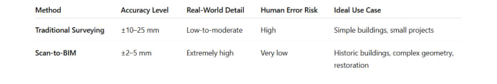
Why Scan-to-BIM Wins on Accuracy
- Point clouds capture millions of data points rather than a few dozen manual measurements
- Laser scanners can record hard-to-reach or hidden details
- Every surface is mapped as-is, regardless of deformation or age
- Documentation is consistent, objective, and repeatable
For heritage structures where every millimeter matters, Scan-to-BIM offers accuracy that manual tools simply cannot match.
4. Time & Efficiency Comparison
- Traditional Surveying
- Requires multiple site visits
- Labor-intensive measurement process
- Long turnaround time for final drawings
- Revision cycles are slow if errors are found
Scan-to-BIM
- Captures the entire site in a single visit
- Faster documentation for large or complex buildings
- Reduces return trips for missed measurements
- Enables quicker decision-making and early design coordination
Most restoration firms report 40–60% time savings with Scan-to-BIM over manual surveying.
5. Safety & Accessibility Considerations
Historic buildings often have:
- Structural instability
- Restricted spaces
- Hazardous materials
- Inaccessible lofts, towers, or crawlspaces
- Traditional Surveying
Requires physical access to every measurement point, increasing safety risks.
Scan-to-BIM
Laser scanners can capture data from a distance, making it ideal for:
- High ceilings
- Fragile areas
- Unsafe floors
- Narrow passageways
- Confined spaces
In many cases, Scan-to-BIM can document areas that would otherwise be impossible to measure.
6. Documentation Quality & Long-Term Value
Traditional Survey Documentation
- 2D plans only
- No depth or deformation information
- Limited longevity
- Hard to update for future renovations
Scan-to-BIM Documentation
- 3D intelligent BIM models
- Geometry, texture, and deformation captured
- Easy to update and reuse
- Supports future restoration, maintenance, and facility management
- Creates a permanent digital archive of the building
For heritage preservation, the long-term digital record is invaluable.
7. Cost Comparison: Which Is More Affordable?
At first glance, traditional surveying seems cheaper—but only if you ignore the hidden costs.
- Traditional Surveying Costs
- Multiple site visits
- High chance of rework
- Errors can lead to design changes and construction delays
Scan-to-BIM Costs
- Higher upfront scanning cost
- But reduced rework
- Fewer site visits
- Faster documentation
- More accurate data = fewer surprises during construction
For complex historic buildings, Scan-to-BIM typically results in overall project savings despite a higher initial cost.
8. When to Use Each Method
Traditional Surveying is suitable for:
- Small buildings
- Basic remodels
- Simple geometry
- Tight budgets with limited accuracy needs
Scan-to-BIM is best for:
- Historic preservation
- Buildings with irregular geometry
- Renovation or adaptive reuse
- Structural analysis
- Detailed documentation
- Government approvals requiring high accuracy
If a building is old, complex, or historically valuable, Scan-to-BIM is the safer and more accurate choice.
Conclusion: Scan-to-BIM Offers Superior Accuracy for Historic Structures
Traditional surveying has its place, but when it comes to historic buildings, accuracy must be as high as possible. Scan-to-BIM shines in environments where precision, safety, and long-term documentation matter most.
By capturing the building’s true geometry—including every deformation, decay pattern, and architectural detail—Scan-to-BIM helps architects and preservation experts make informed decisions, avoid costly mistakes, and preserve historical integrity for generations.
If you're planning a restoration project, Scan-to-BIM isn’t just an upgrade—it’s an essential tool for doing the job right.
Further Reading
- 7 Floor Plan Details Contractors Wish Architects Would Always Include
- How to Choose the Right Industrial Architectural Modeling Partner in the U.S.
- Why Scan-to-BIM Is Transforming Historic Building Restoration?
- Role of BIM and 3D Laser Scanning in Meta Data Center Construction Process
- Implementing 3D Scanning For Heritage Preservation in HBIM Standards
About the Creator
Matt Sharon
A professional content writer. Having years of experience in Technology, health, finance, and construction and real estate field. Writing is my passion and I love to play with words Confidently.
Keep reading
More stories from Matt Sharon and writers in Education and other communities.
7 Floor Plan Details Contractors Wish Architects Would Always Include
Floor plans are the backbone of every construction project. They guide contractors, subcontractors, and field teams—determining how efficiently, accurately, and safely a project can be executed. Yet, many construction delays and onsite change orders stem from missing or incomplete details in the architect’s floor plan drawings.
By Matt Sharon4 months ago in Education
The World’s Safest Countries: Where Doors Stay Unlocked and Police Rarely Carry Guns
In many parts of the world, locking doors, installing security cameras, and relying on heavily armed police forces are everyday realities. However, there are a few countries where life feels very different. In these places, crime rates are extremely low, communities are tightly connected, and trust among citizens is remarkably high. As a result, people often leave their doors unlocked, and in some cases, police officers patrol the streets without carrying firearms.
By Irshad Abbasi 5 days ago in Education
Olena Kalaitan on Mariupol, Journalism, Language, and War in Ukraine
Olena Kalaitan is a Ukrainian journalist and editor best known for leading Mariupol’s Pryazovskyi Robochyi newspaper and heading the Donetsk regional organization of the National Union of Journalists of Ukraine. During Russia’s 2022 siege of Mariupol, she stayed in the city for 23 days, survived the destruction of her home, and escaped on foot with her son. She later became a prominent voice for displaced journalists, media freedom, and the revival of independent Ukrainian journalism in occupied and war-affected regions. Kalaitan has also warned publicly against Russian propaganda issued under the stolen name of her newspaper during wartime occupation there.
By Scott Douglas Jacobsena day ago in Education


Comments (1)
Matt - I would like to contact you about a content opportunity. Do you have a LinkedIn?