
Behind the Scenes of LiDAR Data Processing: Insights from a Mission Coordinator's Perspective
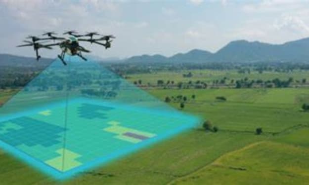
Flying a drone over a forest can gather millions of data points in just a few minutes. But what happens to that data afterward? That’s where the magic begins—behind the scenes, LiDAR (Light Detection and Ranging) data processing turns raw information into valuable insights.

LiDAR technology, often used to create detailed 3D maps of landscapes, relies heavily on precise data processing to make sense of the captured data. This article will explore the processes that go behind LiDAR data processing in detail.
The Role of a Mission Coordinator
A mission coordinator is like the conductor of an orchestra, ensuring that every part of the LiDAR data processing workflow comes together smoothly. One of the first tasks is downloading the logged data onto a processing computer. Though this may sound simple, it sets the foundation for the entire process of the LiDAR mapping services.
A mission coordinator’s role isn’t just about overseeing the technical aspects. They are also responsible for planning the data acquisition, ensuring the flight paths are optimized for the best results, and coordinating with clients to meet their specific needs. It’s a balancing act of managing both the technical workflow and client expectations.
They monitor the progress, ensure data quality, and handle any hiccups along the way. The importance of this role cannot be overstated, as without precise coordination, even the most sophisticated technology can fall short.
LiDAR Data Processing to Turn Raw Data into Insights
So, how does raw LiDAR data become a detailed 3D map? It’s all about the processing steps, each one crucial to the final outcome.
1. Data Download and Initial Processing
The first task after data collection is to transfer the raw data from the drone or aircraft to a processing workstation. This isn’t just about moving files; it involves quality checks to ensure the data is intact and ready for processing. Specialized software is then used to generate an initial point cloud, which is a collection of data points representing the scanned area.
2. Point Cloud Generation
Once the initial data is processed, the real work begins—assembling individual data points into a cohesive point cloud. This process involves correcting the drone’s movement, adjusting for atmospheric conditions, and accurately positioning each point in a 3D coordinate system.
3. Classification and Analysis
Now that the point cloud is generated, it’s time to classify the points. This step categorizes different objects in the data, such as ground surfaces, buildings, or vegetation. This stage can take anywhere from one to two days per class, depending on the dataset’s complexity. This is where the human eye meets machine learning, as advanced algorithms help automate the process while maintaining accuracy.
4. Data Cleaning and Smoothing
After classification, the data is cleaned to remove any noise or outliers. This step ensures that only the most accurate and relevant data remains. It’s like polishing a rough diamond—smoothing the points to create a clear and precise representation of the environment.
Result of LiDAR Data Processing?
Once the data is fully processed, the final products—known as deliverables—can vary depending on the project’s needs. Some common deliverables include:
· Digital Terrain Models (DTM): A representation of the bare ground, minus any objects like buildings or trees.
· Digital Surface Models (DSM): A model that includes all objects, such as buildings and trees, on the surface.
· Contours and Elevation Profiles: Useful for detailed terrain analysis.
· 3D Vector Data: Captures specific features for further analysis, like building footprints or tree canopy heights.
These products serve a wide range of industries, from urban planning and environmental monitoring to infrastructure development.
The Future of LiDAR Data Processing
As technology evolves, LiDAR data processing is becoming more efficient and scalable. Automation through Python scripts and cloud-based systems is transforming workflows, making it easier to process large datasets and collaborate from different locations. The future is not very far away where data cleaning and classification are fully automated, letting mission coordinators focus on higher-level analysis.
With over 20 years of experience, Magnasoft has been a key player in this evolution. Our long history in LiDAR data processing has given us a deep understanding of the technology. We navigate its complexities easily and integrate AI into our workflows to improve precision and efficiency. Our commitment to innovation means we constantly adapt to new advancements, ensuring our LiDAR mapping services remain valuable.
The future looks bright for LiDAR data processing, with cloud solutions paving the way for faster, more accurate results. As these advancements continue, they promise to improve project outcomes across industries, making geospatial analysis more accessible and impactful than ever.
About the Creator
Keep reading
More stories from Khatri Anju and writers in Education and other communities.
The Evolution of Remote Sensing: From Satellites to Drones & Beyond
The landscape of remote sensing has undergone a remarkable transformation in recent times. It is no longer just about capturing grand, blurry aerial photographs. Today, a sophisticated suite of technologies – from high-orbiting satellites to nimble drones – paints a detailed picture of our planet, empowering various industries and government sectors across the globe with unparalleled precision. In fact, a recent report by GeoMarketing suggests that the global market for remote sensing data and services is projected to reach a phenomenal $18.6 billion by 2025, reflecting the ever-increasing demand for geospatial insights across diverse applications.
By Khatri Anju2 years ago in Education
The Role of Mentorship Circles in Shaping Resilient Entrepreneurs
Launching a startup in today’s competitive environment is as much about mindset as it is about innovation. While market knowledge and capital matter, resilience often defines whether a business survives its early stages. One of the most powerful tools in building that resilience is participation in mentorship circles, where emerging entrepreneurs learn, grow, and evolve under the guidance of experienced business leaders.
By Greg Warnockabout 22 hours ago in Education


Comments
There are no comments for this story
Be the first to respond and start the conversation.