
US weather forecast
This storm system will strongly shape weather across the U.S. over the next two days:

General Nationwide Pattern (Next 48 Hours)
1. Widespread Winter Storm Across Much of the U.S.
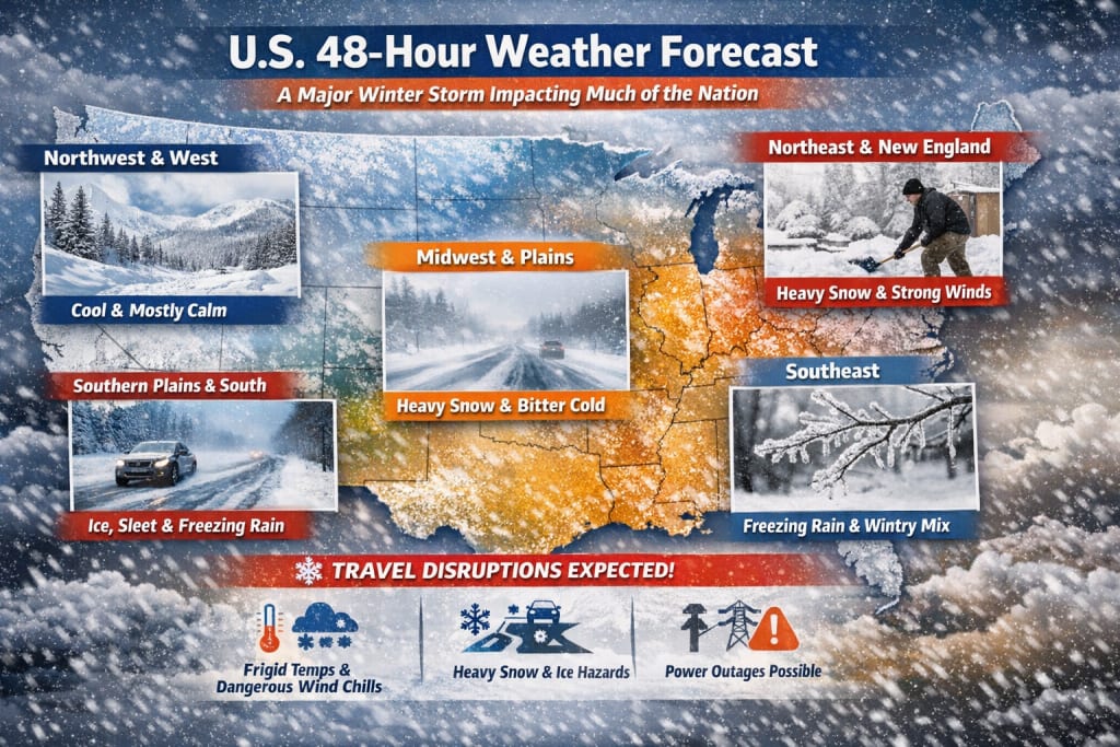
A powerful winter storm is forecast to affect large swaths of the country through the next two days. It is expected to bring heavy snow, ice, freezing rain, and dangerously cold temperatures from the Southern Plains into the Midwest, East Coast, and parts of the Southeast.
Heavy snow expected from Oklahoma and the Midwest up through the Ohio Valley and Northeast.
Ice accumulations and freezing precipitation likely in the Lower Mississippi Valley, Southeast, and parts of the mid-Atlantic.
Dangerously low temperatures and wind chills will accompany the storm, posing risks of frostbite and hypothermia.
This system is large and dynamic — different regions will experience very different conditions as it moves.
Region-by-Region Forecast (Next ~2 Days)
Northeast & Mid-Atlantic
Snowfall: Heavy, particularly from upstate New York through New England into Sunday. Some areas could see a foot of snow or more. �
Times Union
Wind & Cold: Strong winds combined with low temps will create blizzard-like conditions in spots — especially late Saturday into Sunday.
Impact: Travel likely disrupted; snow removal operations underway.
Broad outlook: Snow accumulations continue and winds remain brisk through the period.
Midwest & Ohio Valley
Temperatures: Bitter cold — single digits and below, with wind chills much lower.
Precipitation: Snow is likely in many areas, with heavier bands forming through Friday into Saturday.
Rapid change: This region can shift from relatively calm to storm conditions quickly as the system intensifies.
Southern Plains & Lower Mississippi Valley
Winter Weather: Portions of Texas, Arkansas, Louisiana, and neighboring states may see freezing rain, sleet, and snow; ice accumulation could be significant in some areas, making travel hazardous.
Temperatures: Cold air advection means lows well below freezing in many inland locations.
Note: Dallas-area weather discussion online mentions possible snow this weekend, but specifics may vary and are still forecast-dependent.
Southeast & Lower East Coast
Winter Mix: Some areas may start with rain or sleet and transition to snow as colder air arrives.
Ice Risk: Freezing rain in the Carolinas and nearby states could result in slick roads and power line issues.
Temperatures: Below-normal with lingering chilly lows.
Pacific & Western U.S.
Relative Calm: Western U.S. generally remains cooler than average for this time of year, but no major high-impact weather compared to the central and eastern U.S. (no big storms currently forecast nationally in the West). Latest maps show frontal boundaries and precipitation areas advancing eastward, but nothing as widespread as the central storm.
Overarching Themes Through the Next 48 Hours
❄️ Colder-than-normal conditions
Temperatures across the central and eastern U.S. are well below typical January averages, with many areas experiencing deep freeze conditions.
❄️ Significant snow + ice hazards
The storm’s structure means snow, sleet, and freezing rain will affect travel, infrastructure, and daily routines from Texas to New England over the next two days.
🚫 Travel disruption likely
Airlines are already canceling flights due to weather impacts, and road travel may become hazardous in storm-affected areas.
⚠️ Safety considerations
Cold and storm conditions are serious hazards — frostbite, hypothermia, power outages, and slippery roads are all possibilities where conditions worsen.
Forecast Confidence & Uncertainty
Weather forecasts, especially for two days forward, are generally quite reliable for broad trends (like storm systems, major temperature swings, and precipitation types), but exact timing, snowfall totals, and intensity of impacts can still shift as models update.
Summary (in plain terms)
Today through the next 48 hours across the U.S.:
A major winter storm influences large parts of the country.
Central and eastern regions will see snow and ice with very cold temperatures.
The South could see freezing rain and mixed precipitation.
The West remains relatively calm by comparison.
Conditions will change quickly as the storm system evolves.
About the Creator
USA daily update
News, Politics, Technology Updates
Keep reading
More stories from USA daily update and writers in Earth and other communities.
USA Weather Forecast, Next 3 Days cold
Day 1 — Friday: Winter Storm Impact Begins Across much of the nation from the southern plains to the Northeast, storm conditions will rapidly intensify: Snow and Ice Spread — Snow and freezing rain will expand eastward, leading to slick roads and hazardous travel. Ice accumulations could be significant in certain corridors, particularly across parts of Texas, the Mississippi Valley, and the Southeast.
By USA daily update 2 months ago in Earth
Relativistic Colour and the Physics Behind Gold's Golden Glow
Pick up a piece of gold jewellery and hold it near a window. That warm, unmistakable yellow glow catches the light in a way that feels almost alive. It is not simply pretty. It is, as it turns out, physically extraordinary.
By CurlsAndCommas3 days ago in Earth


Comments
There are no comments for this story
Be the first to respond and start the conversation.