
🌊 Tropical Storm Melissa: A Late-Season Reminder of Nature’s Unpredictable Power
Tracking Tropical Storm Melissa: How a Late-Season System in the Caribbean Could Become a Powerful Hurricane

As the 2025 Atlantic hurricane season begins to wind down, the Caribbean finds itself watching a new name on the map: Tropical Storm Melissa. This late-season system, forming deep in the warm Caribbean waters, is a powerful reminder that hurricane season doesn’t officially end until November 30—and that nature often saves surprises for the final act.
Where Did Tropical Storm Melissa Come From?
Melissa officially formed in mid-October 2025 from a broad area of low pressure in the central Caribbean Sea, about 300 miles south of Haiti and Jamaica. At first, it seemed like a weak, disorganized system. But within just a couple of days, thunderstorms began wrapping tightly around a defined center, earning it a name from the National Hurricane Center.
By the time it strengthened into a tropical storm, Melissa’s winds had reached 50 mph (80 km/h), with tropical-storm-force gusts extending more than 100 miles from its center. While that’s far from hurricane strength, meteorologists quickly noticed something troubling—the environment ahead of Melissa looked ripe for intensification.
The Forecast: A Storm With Growing Potential
Melissa’s future depends heavily on its movement and surrounding atmosphere. Initially, wind shear and pockets of dry air limited its growth. But now, forecasters say conditions are becoming much more favorable: sea-surface temperatures are over 84°F (29°C) and upper-level winds are calming down.
If those trends continue, Melissa could intensify into a hurricane within a few days—and potentially a major hurricane if it lingers over open water. Current forecast models suggest two possible paths:
Northward turn: The storm curves toward Cuba or the Bahamas, possibly avoiding a direct hit on the U.S.
Westward drift: It slides slowly across the Caribbean, posing greater danger to Jamaica, Haiti, and the Dominican Republic.
As of now, it’s still too early to know which path Melissa will take. But one thing is certain—its slow movement means heavy rain is inevitable.
The Real Threat: Rain, Flooding, and Mudslides
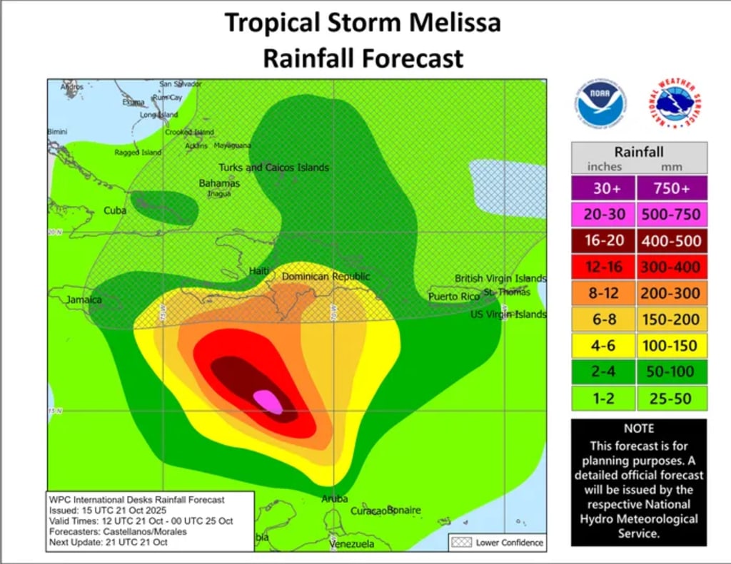
Tropical Storm Melissa’s pace—barely 5 to 7 mph—means it’s likely to dump enormous amounts of rain wherever it goes. Meteorologists warn that 5 to 10 inches could fall across southern Haiti, Jamaica, and the Dominican Republic, with some areas possibly seeing up to 15 inches.
That much rainfall over steep terrain spells serious trouble:
Flash floods could wash through cities and towns.
Mudslides are a major concern in mountainous regions.
Coastal flooding and dangerous surf conditions will affect beaches across the region.
Even areas outside the storm’s direct path, like Puerto Rico and eastern Cuba, could feel ripple effects in the form of gusty winds and high surf. And because Melissa is moving so slowly, communities could face these impacts for several days in a row.
What About the U.S.?
For now, forecasters say the United States is not in immediate danger from Tropical Storm Melissa. The most likely scenario keeps the storm in the Caribbean before curving north and eventually east over the Atlantic.
However, anyone living in Florida or the southeastern U.S. should still keep an eye on updates. Late-season storms sometimes change direction unexpectedly—especially when steering winds are weak, as they are now.
In short: no reason for panic, but plenty of reason for awareness.
Why Melissa Matters
Tropical Storm Melissa isn’t just another storm on the radar—it’s a case study in how late-season systems can surprise even the experts. Here’s why it stands out:
Timing: Forming in late October, it reminds us that hurricane season doesn’t end when the calendar says so.
Slow speed: Melissa’s sluggish pace magnifies rainfall and flood risk, often more dangerous than the wind itself.
Potential strength: With warm waters and calm skies ahead, Melissa could intensify rapidly into a powerful hurricane.
Human impact: Countries like Haiti and Jamaica face heightened vulnerability due to geography and limited infrastructure.
Staying Safe and Prepared
For residents in the Caribbean, preparation is key.
Stay informed through updates from the National Hurricane Center (NHC) and local meteorological services.
Stock up on essentials: food, clean water, and emergency supplies.
Avoid flood zones and have an evacuation plan ready if local authorities issue warnings.
Don’t underestimate slow storms—they often cause more flooding and damage than faster-moving hurricanes.
For those in the U.S., now is the time to review your hurricane readiness plan. Even if Melissa never makes landfall here, it’s a good reminder that preparedness is a season-long mindset.
The Bottom Line
Tropical Storm Melissa might not be the most powerful storm of the year—at least not yet—but it’s an important wake-up call. The Caribbean is bracing for flooding rains, while meteorologists monitor the system’s next move. Whether Melissa fizzles out or becomes a hurricane powerhouse, it underscores one truth about the tropics: the season isn’t over until it’s over.
Stay safe, stay informed, and keep an eye on those forecast updates—the ocean still has a few stories left to tell.
About the Creator
Sajida Sikandar
Hi, I’m Sajida Sikandar, a passionate blogger with 3 years of experience in crafting engaging and insightful content. Join me as I share my thoughts, stories, and ideas on a variety of topics that matter to you.
Keep reading
More stories from Sajida Sikandar and writers in Earth and other communities.
Does Earth Have Two Moons? NASA’s Asteroid Discovery Sparks Global Fascination
For centuries, people have gazed at the night sky believing Earth has just one natural satellite — the Moon. But recent findings by NASA have reignited global curiosity: could Earth actually have a second “moon”? While the answer isn’t as simple as a clear yes, the story of how an asteroid came to be nicknamed Earth’s second moon reveals fascinating truths about orbital mechanics, space exploration, and the ever-changing nature of our cosmic neighborhood.
By Sajida Sikandar3 months ago in Earth
Met Office Issues Yellow Fog Warnings After Parts of UK Battered by Rain
After days of relentless rainfall sweeping across large parts of the United Kingdom, the Met Office has issued yellow fog warnings, cautioning residents and travelers to prepare for reduced visibility and hazardous conditions. The sudden shift from heavy rain to dense fog highlights the volatile nature of the UK’s winter weather and underscores the challenges it poses to transport, public safety, and daily life. From Heavy Rain to Thick Fog The recent spell of intense rain saturated the ground across England, Wales, and parts of Scotland, leaving rivers swollen and fields waterlogged. As calmer weather followed the downpours, a combination of high moisture levels, falling temperatures, and light winds created ideal conditions for fog formation. According to meteorologists, this type of fog—often called radiation fog—develops when moisture near the ground condenses overnight, forming thick, low-lying clouds that can linger well into the morning. The Met Office’s yellow warning signals that fog could significantly reduce visibility, in some areas dropping below 100 meters. While not the most severe level of weather alert, yellow warnings are designed to prompt awareness and caution, particularly for motorists, cyclists, and pedestrians who may be caught off guard during early morning commutes. Travel Disruptions and Safety Concerns Fog is one of the most dangerous weather conditions for road travel, as it can dramatically shorten reaction times and obscure hazards. Authorities have urged drivers to slow down, use fog lights appropriately, and maintain greater distances between vehicles. Motorways and rural roads alike are vulnerable, with sudden patches of thick fog appearing without much warning. Rail services may also experience delays, as drivers are required to reduce speeds when visibility drops. At airports, fog can disrupt flight schedules, causing delays or cancellations, particularly during peak morning hours. Aviation authorities closely monitor visibility thresholds, and even a short-lived fog bank can ripple through tightly scheduled operations. Emergency services have emphasized that pedestrians and cyclists should wear reflective clothing where possible, especially during early mornings and evenings. With darker winter days already limiting visibility, fog compounds the risks for vulnerable road users. Why Fog Follows Heavy Rain Meteorologists explain that fog warnings often follow periods of heavy rainfall. When rain saturates the ground, it leaves behind large amounts of surface moisture. If skies then clear and winds ease, the ground cools rapidly overnight, allowing moisture to condense into fog. This pattern is becoming increasingly familiar in the UK, where weather systems are growing more erratic. Climate scientists note that a warming atmosphere holds more moisture, increasing the likelihood of intense rainfall events followed by fog, frost, or sudden temperature drops. Regional Impact Across the UK The yellow fog warnings are not uniform across the country. Low-lying areas, river valleys, and rural regions are particularly susceptible. Parts of southern England, the Midlands, and eastern regions are among those most at risk, though localized fog could appear almost anywhere conditions align. In Scotland and northern England, lingering wet ground combined with colder overnight temperatures raises the possibility of fog forming alongside icy patches. This mix of hazards further complicates travel and increases the risk of accidents. What a Yellow Warning Really Means A yellow weather warning does not mean severe disruption is guaranteed, but it does indicate a heightened likelihood of impacts. The Met Office uses yellow alerts to encourage the public to stay informed and take sensible precautions. For fog, that means checking travel updates, allowing extra journey time, and staying alert to rapidly changing conditions. Weather experts stress that fog can be highly variable. One area may experience clear skies while another, just a few miles away, is blanketed in thick mist. This unpredictability is what makes fog particularly dangerous. Looking Ahead: More Changeable Weather Forecasts suggest that unsettled weather will continue in the coming days, with further spells of rain interspersed with calmer, colder nights—conditions that could lead to additional fog warnings. While no prolonged severe weather is currently expected, the pattern reflects the broader trend of increasingly changeable winters in the UK. For many residents, this serves as another reminder that winter weather is no longer defined by just cold or snow. Instead, a mix of heavy rain, flooding risks, fog, and sudden temperature shifts is becoming the new normal. Staying Prepared The Met Office advises the public to regularly check forecasts, especially before traveling, and to remain flexible with plans during periods of weather warnings. Simple measures—such as cleaning car windows, ensuring lights are functioning, and staying updated via official channels—can significantly reduce risk. As the UK continues to navigate this wet and fog-prone winter, awareness and preparation remain the best defenses. While the fog may lift by midday in many areas, its early impact serves as a timely reminder that even seemingly mild weather hazards can have serious consequences.
By Fiaz Ahmed 3 days ago in Earth
O-Ring Seals Market Size and Forecast 2025–2033
Introduction In an era defined by advanced engineering, sustainability goals, and performance efficiency, the smallest components often play the biggest roles. Among these unsung heroes of modern manufacturing are O-ring seals—simple, circular devices that quietly prevent leaks, ensure safety, and keep critical systems functioning under extreme conditions.
By Aaina Oberoi5 days ago in Earth
Wild Card Weekend Recap: What Happens Now?
I think I figured out why I love Wild Card Weekend so much. It's because it's the first playoff anything of the calendar year. The NFL season starts in the fall, and once upon a time, the champion was crowned either on or slightly before New Year's. The evolution of the NFL schedule has resulted in the playoffs starting just into the New Year, and currently, the final week of the season falls on the first weekend of the New Year, with Wild Card Weekend coming a week after that. So yes, chronologically, the NFL's Wild Card Weekend serves as the first playoff anything of the calendar year.
By Clyde E. Dawkins6 days ago in Unbalanced


Comments
There are no comments for this story
Be the first to respond and start the conversation.