
This Cloud Screams Danger, Run Away If You See It
Lets Dive In

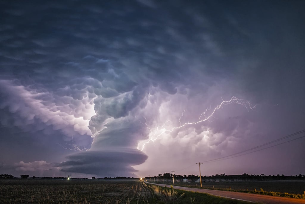
Take a look at this ominous dark cloud. Is it rotating? What on Earth is happening here? What you're witnessing is known as a supercell, a type of storm, often a thunderstorm, characterized by an updraft that rotates around a vertical axis. That's why they're also referred to as rotating thunderstorms.
There are four types of thunderstorms: single-cell, multi-cell, squall line, and supercell. Among them, supercells are the rarest and most severe. They are typically isolated from other thunderstorms and can last for two to four hours.
Supercells are prevalent in the Great Plains of the United States, especially in the region known as Tornado Alley. However, they can also occur in other parts of the world, including Europe, Argentina, Uruguay, and Southern Brazil. These storms can vary in size, from large to small, with high or low tops. Supercells are often associated with the most severe tornadoes, although not every supercell can produce one. These storms typically generate heavy rainfall, hail, and powerful winds, along with downbursts.
Downbursts are strong winds that descend from a thunderstorm and rapidly spread out upon reaching the ground. They can cause significant damage and are sometimes mistaken for tornadoes, but they are distinct phenomena.
Let's delve into how a downburst forms. At the start of a thunderstorm, a powerful updraft causes the cloud to grow vertically, and hailstones and raindrops begin to form inside. As the storm progresses and the updraft continues feeding the cloud with unstable moist air, the hailstones and raindrops become larger and heavier, eventually falling to the ground. However, in some cases, the updraft can be so strong that it suspends a substantial amount of rain and hail in the upper and central parts of the storm.
If dry air infiltrates the middle and lower portions of the storm, it can trigger a downburst. This causes the accumulated rain and hail from the upper part of the storm to rush downward, dragging a significant amount of air with it. As the downburst reaches the ground, it spreads in all directions at remarkable speeds, sometimes exceeding 100 miles per hour.
On a smaller scale, you may encounter a microburst, which confines these powerful winds to an area smaller than 2.5 miles in diameter.
While we're discussing tornadoes, it's worth mentioning volcanic tornadoes, one of the most frightening natural phenomena. When a volcano erupts, it propels hot rocks and ash high into the atmosphere, while lava and hot gases flow down the volcano's slope. As the gases rise and spin, they become compressed by the surrounding air, causing them to rotate faster and faster. This is how a volcanic tornado emerges. Fortunately, this phenomenon has a short lifespan.
If you ever witness a tightly spiraling column of air accompanied by fire, that's a fire tornado. It combines the whirlwind effect with a scorching inferno. This dangerous natural occurrence primarily takes place during wildfires when the hot air generated mixes with cooler air higher up, resulting in a whirlwind that churns up burning debris and flames. The most powerful fire tornadoes can extend hundreds of feet into the sky.
Another perilous phenomenon is a snow squall, an intense period of heavy snowfall accompanied by powerful gusty winds and, sometimes, lightning. Snow squalls make driving hazardous, as they significantly reduce visibility. Additionally, a flash freeze can occur when rapidly dropping temperatures cause freshly fallen snow to quickly glaze over roads, making vehicle control nearly impossible.
Now, let's explore a rarely seen and poorly understood phenomenon—dust devils. Unlike their terrifying counterparts, tornadoes, dust devils are generally harmless. These swirling vortices can be small and short-lived, often disappearing within minutes. They go by various names, including whirlwinds, dusters, and sand spouts. Dust devils can swirl loose debris, provided it is small and light enough to be lifted by the fast-moving vortex.
Did you know that certain cloud formations can predict extreme weather? For instance, shelf clouds, which resemble something from a science fiction movie, form when warm and moist air becomes trapped in a thunderstorm updraft. These foreboding clouds often signal an impending storm. Another distinctive cloud type is mammatocumulus, which gives the impression that the sky is falling. These clouds form when cool, moist air descends and mixes with dry air, resulting in unique, puffed rice-like formations. When spotted, mammatocumulus clouds indicate that bad weather is imminent.
Morning Glory clouds are extremely rare and harmless. They appear as massive tubes stretching across the sky, sometimes extending over 600 miles. Researchers believe they form when an updraft squeezes through the cloud, creating a rolling appearance. The cool air at the back of the cloud causes it to sink downward. The best place to observe Morning Glory clouds is Australia's Gulf of Carpentaria between late September and early November.
Have you ever seen large round discs in the sky? Most likely, those were lenticular clouds. They typically form over high, mountainous areas when strong winds encounter a barrier, creating an airwave. As the rising air encounters the cooler temperatures at higher altitudes, moisture condenses into water droplets, forming these distinctive cloud shapes. Lenticular clouds can resemble waves, pizzas, or stacks of pancakes.
On the contrary, rainbow clouds occur low in the sky, usually above puffy, low-altitude clouds after thunderstorms. They hover around 6,000 feet and result from water vapor condensing into droplets, which act as prisms, producing multicolored caps over the clouds.
As a bonus fact, one of the common causes of wildfires is lightning from thunderstorms. However, it is interesting to note that wildfires can also trigger thunderstorms. A notable example occurred on May 11, 2018, near Amarillo, Texas. The intense Mallard Fire generated a dense, massive cloud high in the atmosphere, while its heat generated a violent thunderstorm that subsequently produced quarter-sized hailstones 60 miles away in Wheeler County, Texas.
That concludes our exploration of these intriguing natural phenomena. If you found this information captivating, please like and share the video with your friends. For more engaging content, click on the suggested videos and stay on the bright side.
About the Creator
Random Facts
hope you guys enjoy the stories i publish, please support and like
thank you
Keep reading
More stories from Random Facts and writers in Earth and other communities.
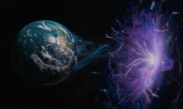
What Would Happen If Earth Fell into a Black Hole
Black holes are some of the most mysterious and intriguing phenomena in the universe. They possess a sinister quality, capable of devouring entire stars and planets while distorting the fabric of space and time. But what if our home planet, Earth, were to fall under the grip of a black hole's event horizon? What would we witness before the inevitable end? Let's explore this scenario.
By Random Facts3 years ago in Earth
Europe Hydro Turbine Market Size and Forecast 2025–2033
Introduction The Europe Hydro Turbine Market is projected to grow from US$ 542.44 million in 2024 to US$ 840.78 million by 2033, registering a compound annual growth rate (CAGR) of 4.99% during 2025–2033. This expansion is being powered by Europe’s accelerating investments in renewable energy, the modernization of aging hydropower infrastructure, and strong regulatory backing for low-carbon electricity generation across key countries such as Norway, France, Austria, and Switzerland.
By Marthan Sir2 days ago in Earth
"NASA satellites confirm that China’s Great Green Wall is effectively slowing desert expansion and reshaping entire regions
NASA satellite data has confirmed what scientists, policymakers, and local communities in China have hoped for decades: the Great Green Wall is working. Designed to slow the relentless expansion of deserts across northern China, this ambitious ecological project is not only reducing desertification but also reshaping entire regions—environmentally, economically, and socially. Often compared to Africa’s Great Green Wall, China’s version is one of the largest environmental engineering projects in human history. Officially known as the Three-North Shelter Forest Program, it stretches across northern, northeastern, and northwestern China, covering an area larger than many countries. Launched in 1978, the project aims to combat desert expansion, reduce sandstorms, protect farmland, and stabilize local climates through large-scale tree planting and vegetation restoration. For years, critics questioned whether planting trees in arid and semi-arid regions was sustainable. Some argued that trees would consume scarce groundwater, while others doubted whether satellite images could capture meaningful ecological change. Now, decades later, NASA’s satellite observations provide compelling evidence that the Great Green Wall is having a measurable and positive impact. According to satellite data, vegetation cover across northern China has increased significantly. Areas once dominated by shifting sand dunes now show stable plant growth, reduced soil erosion, and improved land productivity. These changes are not isolated; they span vast regions, indicating that the project is influencing ecosystems on a continental scale. Desert expansion, once advancing at alarming rates, has slowed dramatically in several high-risk zones. One of the most visible benefits has been the reduction in sandstorms. Cities like Beijing, which once endured frequent and severe dust storms originating from nearby deserts, have seen noticeable improvements in air quality. NASA imagery reveals that wind-blown dust has decreased as vegetation acts as a natural barrier, anchoring soil and reducing airborne particles. This has direct public health benefits, lowering respiratory illnesses and improving overall quality of life for millions of residents. Beyond environmental gains, the Great Green Wall is reshaping regional economies. Stabilized land allows farmers to reclaim fields once lost to encroaching deserts. In some areas, agroforestry—combining trees with crops—has created new income streams while maintaining ecological balance. Satellite data shows that these mixed-use landscapes are more resilient to drought and climate extremes than monoculture farming systems. The project has also influenced local climate patterns. Increased vegetation helps regulate surface temperatures and moisture levels. NASA observations indicate slight increases in local rainfall and reductions in surface heat in reforested zones. While these changes may seem modest, over large areas they contribute to more stable weather patterns and reduced vulnerability to climate shocks. However, the success of the Great Green Wall is not uniform. Satellite analysis also reveals areas where tree survival rates are low or where non-native species struggle to adapt. In response, China has adjusted its strategy, shifting from mass tree planting to ecosystem-based restoration. This includes planting native grasses and shrubs, restoring wetlands, and allowing natural regeneration where possible. The evolving approach reflects lessons learned from decades of experimentation. Another key factor behind the project’s effectiveness is long-term commitment. Unlike short-term environmental campaigns, the Great Green Wall spans generations. NASA’s ability to track changes over decades has been crucial in demonstrating progress that would be invisible on shorter timelines. This long-view perspective underscores an important lesson for global climate efforts: meaningful ecological recovery takes time, patience, and sustained investment. Internationally, China’s experience is drawing attention. Countries facing desertification—from parts of Africa to the Middle East and Central Asia—are studying the Great Green Wall as a model. NASA’s confirmation adds scientific credibility, showing that large-scale land restoration can work when supported by data, adaptive management, and local participation. Still, challenges remain. Climate change continues to intensify droughts, heatwaves, and extreme weather events, threatening fragile restored ecosystems. Experts caution that the Great Green Wall is not a permanent solution but a dynamic system that requires continuous monitoring, maintenance, and adaptation. Satellite technology will remain essential in identifying stress points and guiding future interventions. In the end, NASA’s findings do more than validate a single project—they reshape how we think about humanity’s relationship with nature. The Great Green Wall demonstrates that environmental degradation is not always irreversible. With science, long-term planning, and political will, even vast deserts can be slowed, reshaped, and partially healed. As the world searches for solutions to climate change and land degradation, China’s Great Green Wall stands as a powerful example: proof that large-scale environmental action, guided by data from space, can transform landscapes on Earth.
By Fiaz Ahmed about 6 hours ago in Earth
Miss Persephone's Manual to a Seemingly Ordinary Life
Miss Persephone was found at the dining table, her blue eyes swollen, her tears arriving and retreating like the tides of the ocean. Earlier that day, her family had visited her in the retirement home where she had lived for eight years. It was her eightieth birthday.
By Imola Tóth2 days ago in Fiction


Comments
There are no comments for this story
Be the first to respond and start the conversation.