


The Yellow River, which has given birth to Chinese civilization and sons and daughters, is the "mother river" of the Chinese nation.
The Yellow River originates from the Bayan Kara Mountains on the Qinghai-Tibet Plateau and flows from west to east through nine provinces (autonomous regions) of Qinghai, Sichuan, Gansu, Ningxia, Inner Mongolia, Shaanxi, Shanxi, Henan and Shandong, and finally flows into the Bohai Sea. Heyuan to Hekou Town in Inner Mongolia Autonomous region in the upper reaches, Taohuayu in Henan Province in the middle reaches, and Taohuayu to the estuary in the lower reaches, showing a "few" distribution as a whole.
Li Bai, a poet of the Tang Dynasty, once described, "Don't you see that the water of the Yellow River comes from the sky, and the waves rush to the East China Sea and never look back?" Liu Yuxi described it as "thousands of miles of twists and turns of the Yellow River carrying silt, the waves rolling like a huge wind from the end of the world." We can see the characteristics of the Yellow River:
It is recommended to watch horizontally.
Haohukou Waterfall
First, there is more sand. Regardless of the annual sediment transport or the average sediment concentration, the Yellow River ranks first among the rivers in the world. The average annual sediment is 1.6 billion tons, which is piled into embankments 1 meter high and 1 meter wide, with a length of 27 circles around the equator, and an average sediment content of 35 kilograms per cubic meter, which is equivalent to 35 kilograms of sediment in one ton of water in the Yellow River.
Second, there are many bays and changeable flow directions, resulting in a large number of bays and loops.
Third, the combination of the new and the old, the downstream river after diversion, its formation time is only hundreds of years or even decades.
Fifth, the drop in the water surface is large, with a drop of 4480 meters from the source to the estuary.
Xiaolangdi flood discharge and sediment discharge
The sediment content of the Yellow River is large, according to statistics, about 89.1% comes from the "sandy and coarse sand area" in the middle reaches (1.182 billion tons), while in the lower reaches, due to the construction of embankments and other water conservancy projects, the river becomes narrower, and a large amount of sediment with a particle size greater than 0.05mm is deposited on the riverbed, causing the riverbed to rise, causing the river course 800km below Huayuankou to become a "overhanging river", also known as "first-class suspended river".
In the 1960s, with the construction of the water control project in the upper and middle reaches of the Yellow River, the number of major floods in the lower reaches decreased, and the sediment deposition in medium and small floods and low water periods mainly occurred on the main channel and Nentan. As a result, the bottom of the main channel from Dongbatou to Taochengpu in the lower reaches is higher than the beaches on both sides, forming a "secondary suspended river", and the Yellow River becomes a suspended river.
Schematic diagram of "overhanging river"
The reason for the formation of the "overhanging river" of the Yellow River is mainly affected by climate change and human activities.
About 5000 years ago, the climate of the Yellow River basin was warm and humid, the precipitation was abundant, and the vegetation was relatively lush. At that time, human beings were in the primitive era, the population was sparse, and the production tools used were very simple. The Loess Plateau is basically in a state of natural erosion.
From about after the Shang and Zhou dynasties to before the warring States period, the human economic activities in the Yellow River basin increased significantly, and the population gradually densed, but the productivity was still low, the climate was humid, the precipitation was more, and the forest and grass was more luxuriant. At that time, there was not only one channel in the lower reaches of the Yellow River, but wandered in the plain, forming multiple channels, so it was called "Nine Rivers". During this period, the riverbed silted slowly and the crevasse was not diverted much.
After the warring States period, due to the development of productive forces, people began to plant a large area of agriculture on the Loess Plateau, which changed the microclimate environment in the middle reaches of the Yellow River and made the vast area of the Loess Plateau dry. As a result, the surface of the Loess Plateau is fragmented and ravines are vertical and horizontal, which greatly accelerates the soil and water loss on the Loess Plateau. At the same time, large-scale dikes were built, and the flood of the Yellow River was classified into a fixed channel, forming a vast beach to detain the flood and settle sand, a large amount of sediment was concentrated between the levees on both sides of the strait year after year, and the riverbed continued to rise.
Night view of Li Yang
By the end of the Western Han Dynasty around 6 BC, it has been recorded that the riverbed near Liyang (now Junxian County, Henan Province) has been higher than the residential houses, forming a veritable "first-class suspended river".
The reasons for the formation of the "secondary suspended river" are mainly the following three aspects: first, the water and sediment conditions have changed significantly, the flood peak frequency and flood peak discharge have been significantly reduced, the bed-making effect of flood has been weakened, and the river plane and cross-section scale have been reduced. as a result, the siltation of the river is limited to the small and medium-sized main channel, and the main channel and tender beach have been silting all the time. Second, the boundary conditions of the river bed have changed greatly, and the construction of a large number of river regulation projects has made the main channel of the lower reaches relatively stable, creating a relatively stable place for sediment deposition. Third, the construction of the production dike in the beach area further narrows the flood discharge channel. When the great flood overflows the production embankment, the siltation thickness decreases gradually with the distance between the beach and the channel, which aggravates the channel shape with the beach lip high and the dike root low-lying.
After the Yellow River became a "suspended river on the ground", crevices and diversion occurred frequently. According to records, during the 2540 years from the pre-Qin period to the Republic of China (602-1938 BC), the Yellow River broke its mouth more than 1590 times and changed its course 26 times, including 9 major ones. There is a common saying that "two breaches in three years and one change in a hundred years" makes the people on both sides of the Yellow River miserable, and the safety problems in the lower reaches of the Yellow River are mainly caused by the continuous rise of the riverbed.
The Hebei-Shandong-Henan Yellow River Water Conservancy Commission was established (Director Wang Huayun on the right in the front row
Second platoon, right one, Academician Qian Zhengying)
In 1964, according to the experience gained in the application of Sanmenxia Reservoir, the strategy of controlling the Yellow River was adjusted to "upper stop and lower discharge". In 1975, a severe flood occurred in the Huaihe River, causing heavy casualties. Similar problems also occurred in the process of preventing and controlling the Yellow River, and the strategy for controlling the Yellow River was adjusted to "upper and lower drainage, separate stagnation on both sides".
Since the 1980s, with the improvement of the level of science and technology, the idea of sediment control has been constantly improved. finally, it has formed the contemporary strategy of "stopping, draining, regulating, releasing and digging" to control the Yellow River. "blocking" mainly refers to the
About the Creator
Keep reading
More stories from Fwuebks Sushma and writers in Earth and other communities.
Talking about Qiantang River from the River of Tide
The float in the river of the tide passes through Tiananmen Square. Zhijiang is a nickname of the Qiantang River from Wenyan to Zhakou section in Xiaoshan District, Hangzhou City, Zhejiang Province. The tortuous flow of the river is like the word "Zhi", hence the name. Qiantang River was first known in the Classic of Mountains and Seas. It got its name from flowing through the ancient Qiantang County. Qiantang is today's Hangzhou.
By Fwuebks Sushma3 years ago in Earth
How Much Do You Need in an ISA for a Passive Income That Beats the State Pension?
For many people in the UK, the State Pension is expected to form the backbone of retirement income. But with rising living costs and growing uncertainty about the future, more savers are asking a crucial question: Can I build a passive income that beats the State Pension — and how much would I need in an ISA to do it?
By Aarif Lashari2 days ago in Earth
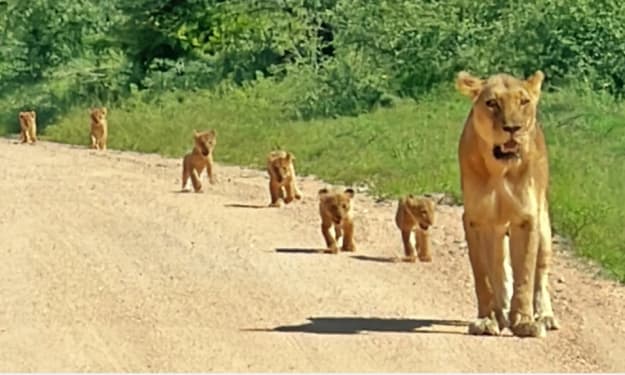
Tiny Lion Cubs Struggle To Keep Up With Mom
In the heart of the African savannah, life is a constant lesson for young animals. Few scenes are as endearing — or as heartwarming — as tiny lion cubs trying to keep pace with their mother. These little bundles of fur face a world full of challenges, from learning to hunt to avoiding dangers, all while depending on the guidance and protection of their experienced mom. Watching cubs wobble and tumble as they attempt to keep up with their mother reminds us that growing up, even in the wild, is a journey full of struggle, determination, and adorable missteps. The Early Days of Lion Cubs Lion cubs are born blind and helpless, usually in litters of two to six. For the first few weeks, they rely entirely on their mother for warmth, food, and safety. Even after opening their eyes and beginning to explore, the cubs are far from independent. The first months are crucial. Cubs learn social cues, hunting basics, and survival skills simply by watching their mother and the pride. But as anyone who has observed them knows, there’s often a huge gap between observation and action. Tiny cubs often struggle to match their mother’s pace, especially when she moves through long stretches of savannah or leads the family on patrols. A Mother’s Role in the Wild For a lioness, raising cubs is a full-time commitment. She hunts, defends her territory, and teaches her young, all while staying alert to predators such as hyenas, leopards, and even rival lions. The cubs, meanwhile, attempt to mimic her every move — often with clumsy yet charming results. A mother lion’s patience is remarkable; she frequently slows down, nudges them along, or stops to ensure no cub is left behind. These moments, while stressful for the tiny cubs, are vital learning opportunities. Struggling to Keep Up: Why It’s So Hard There are several reasons why tiny lion cubs have trouble keeping pace with their mother: Short Legs, Big Steps: Lion cubs’ legs are tiny and their coordination is limited, making it difficult to cover the same distance as an adult lioness. Curiosity: Cubs are naturally curious. A single butterfly or rustling bush can distract them, leaving mom to pause repeatedly. Energy Levels: Young lions tire quickly. Even with frequent naps, the cubs’ stamina is far lower than their mother’s. Learning Through Play: Play is not just fun; it teaches hunting, balance, and social skills. Running off to pounce on a sibling or chase an insect is all part of their education. Despite these challenges, the cubs’ determination to keep up demonstrates their resilience and growing understanding of the wild world. Lessons in Teamwork and Survival Every cub struggling to keep up is also learning crucial survival skills. The journey across the savannah is more than a test of speed — it’s a lesson in: Coordination: Cubs learn how to move efficiently across different terrains. Patience: They begin to understand the rhythms of adult life and the pace required for survival. Social Skills: Staying with the group teaches cubs how to interact with siblings and the pride, which is essential for their future roles. Observation: By following their mother, cubs study hunting techniques, territorial behavior, and predator awareness. Even the moments when cubs stumble or lag behind are essential for their development. These experiences prepare them for independence, which comes sooner than many might expect. The Cutest Moments in the Wild Anyone who has watched tiny lion cubs knows that their struggles are often irresistibly cute. Video clips from wildlife reserves frequently show cubs toddling along, tumbling over each other, or getting distracted mid-step. Observers often comment that these little stumbles reveal personality, determination, and playfulness, making them one of nature’s most heartwarming spectacles. While their mother is serious and focused, the cubs inject a sense of humor and lightness into life on the savannah. Why This Matters The struggles of lion cubs aren’t just adorable — they’re vital for understanding wildlife behavior. Conservationists and animal behaviorists use these moments to study growth patterns, social structures, and survival strategies in lion populations. These observations also highlight the importance of preserving natural habitats. Cubs must learn in a safe environment to survive; habitat loss, poaching, and climate change make these early struggles even more dangerous. Protecting the African savannah ensures that future generations of lions can experience the same lessons and playful tumbles. The Road to Independence Within a year, these tiny cubs will be more agile, faster, and more confident. By the time they reach two to three years old, males may begin to leave the pride, while females often stay and become caretakers themselves. Every misstep, tumble, and lagging moment is part of the journey toward strength, coordination, and independence. Watching them now gives us a glimpse of the challenges they will overcome, and the survival skills they will carry for life. A Celebration of Motherhood Ultimately, these scenes remind us of the incredible bond between mother and cubs. Her patience, vigilance, and teaching are the foundations of their future. The cubs’ struggles highlight the trials of growing up, while their determination showcases the resilience and beauty of wildlife. For those observing, it’s a powerful lesson in care, guidance, and perseverance, not just in lions but in the natural world as a whole. Final Thoughts Watching tiny lion cubs try to keep up with their mother is both entertaining and enlightening. It’s a story of growth, struggle, and resilience — a reminder that even the fiercest creatures start small, learning step by step. These little lions capture hearts while teaching life lessons: patience, determination, teamwork, and the importance of guidance. As they tumble and waddle across the savannah, they show us that growth is a process, one adorable misstep at a time. For wildlife enthusiasts, animal lovers, and anyone enchanted by nature, these tiny cubs are proof that even in the wild, love, care, and persistence are universal truths.
By Aarif Lashari2 days ago in Earth
Ludacris and Nelly draw backlash over bookings at MAGA-coded music festival
Ludacris and Nelly headlining a mostly right-wing event is good for them. It’s also great for the genre of hip hop. The two rap veterans have showcased their talents on other stages. Why can’t they perform for mostly MAGA folks and grab that bag?
By Skyler Saunders6 days ago in Beat


Comments
There are no comments for this story
Be the first to respond and start the conversation.