
Severe Cold and Dangerous Winter Storm Bear Down on the D.C. Area
A major winter storm is approaching Washington, D.C., bringing heavy snow, ice, and dangerously cold temperatures — here’s what residents need to know to stay safe and prepared.


The nation’s capital and surrounding areas of Maryland and northern Virginia are bracing for a severe winter storm this weekend. Officials have issued winter storm warnings, while local and state governments have declared states of emergency to prepare for potentially dangerous conditions. The storm is expected to deliver heavy snow, freezing rain, and bone-chilling cold, creating hazardous travel conditions and widespread disruptions for residents.
Meteorologists warn that this is not a typical winter snowstorm. With accumulations expected between 7 and 14 inches, along with sleet and ice in some areas, this storm could challenge communities across the D.C. metropolitan area. In addition, frigid temperatures are expected to persist even after the snow ends, creating prolonged hazards for anyone venturing outdoors.
Friday: Arctic Air Arrives
Before the snow begins, the D.C. region will feel the impact of arctic air sweeping in Friday, dropping temperatures into the low teens and single digits. Wind chills may plunge below zero, making it feel even colder. This initial blast of cold sets the stage for snow to stick quickly once precipitation begins.
Authorities are urging residents to prepare early: stock up on essentials, secure homes, and check heating systems. With roads still mostly clear, Friday is the last opportunity to travel safely before the storm begins in earnest.
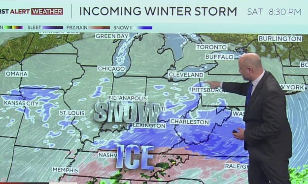
Saturday Night: Snow Begins
The storm is expected to begin late Saturday evening, between 7 p.m. and 10 p.m.. The first snowflakes will fall lightly, but accumulation may start quickly due to the cold temperatures. Early snowfall will likely be concentrated in northern and western suburbs before spreading throughout the metro area.
By midnight Saturday, some areas may already have 1–2 inches of snow.
Roads may start to become slippery, especially untreated side streets, overpasses, and bridges.
Residents are advised to avoid unnecessary travel, as conditions can deteriorate quickly once snow accumulates.
Sunday Morning: Snow Intensifies
Sunday marks the storm’s peak intensity, particularly in the morning hours. By 5 a.m., widespread snow is expected across Washington, D.C., and surrounding areas.
Snowfall rates could reach 1–2 inches per hour, reducing visibility and making commuting dangerous.
Accumulations in many areas may reach 3–5 inches by mid-morning.
Schools, offices, and public services are likely to face delays or closures, while residents should monitor updates closely.
For parts of Maryland and northern Virginia, snow may mix briefly with sleet and freezing rain, adding to the danger of icy roads and sidewalks.
Sunday Afternoon to Evening: Peak Snow and Ice
The heaviest snowfall is forecast for Sunday afternoon and early evening, when total accumulation could reach 6–12 inches, with northern and western suburbs seeing the highest totals.
Driving will become extremely hazardous as roads become snow-covered and icy.
Public transit and commuting may be delayed or suspended in certain areas.
Freezing rain may continue in some spots, increasing the risk of downed tree limbs and power outages.
Residents are strongly advised to stay indoors during the peak hours and ensure that heating systems and emergency supplies are ready.
Sunday Night into Monday Morning: Storm Winds Down
By Sunday evening, snow and ice are expected to gradually taper off, though occasional flurries or light freezing drizzle may persist into Monday.
Roads may remain dangerous overnight, especially untreated side streets.
Total accumulation could reach 14 inches or more in some areas by the time snow ends.
Temperatures will stay below freezing, meaning snow and ice may not melt for several days.
Even as the storm passes, residents will need to continue exercising caution for travel and outdoor activity. Municipal snow removal efforts may take time due to the extended cold.
Government Response and Community Preparations
In anticipation of the storm, Washington, D.C., Maryland, and Virginia authorities have activated emergency plans. Local governments are:
Pre-treating roads and major thoroughfares.
Enforcing snow emergency routes and parking restrictions.
Deploying crews to respond to power outages and tree damage.
Utility companies have staged crews to quickly respond to downed lines caused by heavy snow and ice. Residents are encouraged to follow official guidance and stay updated on alerts through local news and government websites.
Community preparedness is also critical. Residents should:
Stock essential supplies, including food, water, and medications.
Check on neighbors, especially the elderly or vulnerable populations.
Avoid travel during peak storm hours to reduce accidents and allow emergency crews to operate efficiently.
Protect pets and property from extreme cold and ice buildup.
Why This Storm Matters
The combination of heavy snow, ice, and dangerous cold makes this storm especially hazardous. Unlike typical snowstorms, the addition of freezing rain in certain areas, coupled with prolonged subzero temperatures, could lead to extended disruptions in transportation, utilities, and daily life.
For residents, this is not just a weather event — it is a community challenge, requiring preparation, awareness, and cooperation. Public safety officials emphasize the importance of taking the storm seriously, even if past snow events have seemed manageable.
Looking Ahead
The D.C. area is facing a winter storm that will test both municipal response and community preparedness. With snow starting late Saturday night, peaking Sunday afternoon, and tapering Monday morning, residents need to plan ahead to ensure safety and minimize disruption.
From commuting to staying warm indoors, preparation is key. The storm’s combination of heavy snowfall, ice accumulation, and prolonged frigid temperatures makes early action essential for protecting families, neighbors, and property.
About the Creator
Asad Ali
I'm Asad Ali, a passionate blogger with 3 years of experience creating engaging and informative content across various niches. I specialize in crafting SEO-friendly articles that drive traffic and deliver value to readers.
Tiny Lion Cubs Struggle To Keep Up With Mom
In the heart of the African savannah, life is a constant lesson for young animals. Few scenes are as endearing — or as heartwarming — as tiny lion cubs trying to keep pace with their mother. These little bundles of fur face a world full of challenges, from learning to hunt to avoiding dangers, all while depending on the guidance and protection of their experienced mom. Watching cubs wobble and tumble as they attempt to keep up with their mother reminds us that growing up, even in the wild, is a journey full of struggle, determination, and adorable missteps. The Early Days of Lion Cubs Lion cubs are born blind and helpless, usually in litters of two to six. For the first few weeks, they rely entirely on their mother for warmth, food, and safety. Even after opening their eyes and beginning to explore, the cubs are far from independent. The first months are crucial. Cubs learn social cues, hunting basics, and survival skills simply by watching their mother and the pride. But as anyone who has observed them knows, there’s often a huge gap between observation and action. Tiny cubs often struggle to match their mother’s pace, especially when she moves through long stretches of savannah or leads the family on patrols. A Mother’s Role in the Wild For a lioness, raising cubs is a full-time commitment. She hunts, defends her territory, and teaches her young, all while staying alert to predators such as hyenas, leopards, and even rival lions. The cubs, meanwhile, attempt to mimic her every move — often with clumsy yet charming results. A mother lion’s patience is remarkable; she frequently slows down, nudges them along, or stops to ensure no cub is left behind. These moments, while stressful for the tiny cubs, are vital learning opportunities. Struggling to Keep Up: Why It’s So Hard There are several reasons why tiny lion cubs have trouble keeping pace with their mother: Short Legs, Big Steps: Lion cubs’ legs are tiny and their coordination is limited, making it difficult to cover the same distance as an adult lioness. Curiosity: Cubs are naturally curious. A single butterfly or rustling bush can distract them, leaving mom to pause repeatedly. Energy Levels: Young lions tire quickly. Even with frequent naps, the cubs’ stamina is far lower than their mother’s. Learning Through Play: Play is not just fun; it teaches hunting, balance, and social skills. Running off to pounce on a sibling or chase an insect is all part of their education. Despite these challenges, the cubs’ determination to keep up demonstrates their resilience and growing understanding of the wild world. Lessons in Teamwork and Survival Every cub struggling to keep up is also learning crucial survival skills. The journey across the savannah is more than a test of speed — it’s a lesson in: Coordination: Cubs learn how to move efficiently across different terrains. Patience: They begin to understand the rhythms of adult life and the pace required for survival. Social Skills: Staying with the group teaches cubs how to interact with siblings and the pride, which is essential for their future roles. Observation: By following their mother, cubs study hunting techniques, territorial behavior, and predator awareness. Even the moments when cubs stumble or lag behind are essential for their development. These experiences prepare them for independence, which comes sooner than many might expect. The Cutest Moments in the Wild Anyone who has watched tiny lion cubs knows that their struggles are often irresistibly cute. Video clips from wildlife reserves frequently show cubs toddling along, tumbling over each other, or getting distracted mid-step. Observers often comment that these little stumbles reveal personality, determination, and playfulness, making them one of nature’s most heartwarming spectacles. While their mother is serious and focused, the cubs inject a sense of humor and lightness into life on the savannah. Why This Matters The struggles of lion cubs aren’t just adorable — they’re vital for understanding wildlife behavior. Conservationists and animal behaviorists use these moments to study growth patterns, social structures, and survival strategies in lion populations. These observations also highlight the importance of preserving natural habitats. Cubs must learn in a safe environment to survive; habitat loss, poaching, and climate change make these early struggles even more dangerous. Protecting the African savannah ensures that future generations of lions can experience the same lessons and playful tumbles. The Road to Independence Within a year, these tiny cubs will be more agile, faster, and more confident. By the time they reach two to three years old, males may begin to leave the pride, while females often stay and become caretakers themselves. Every misstep, tumble, and lagging moment is part of the journey toward strength, coordination, and independence. Watching them now gives us a glimpse of the challenges they will overcome, and the survival skills they will carry for life. A Celebration of Motherhood Ultimately, these scenes remind us of the incredible bond between mother and cubs. Her patience, vigilance, and teaching are the foundations of their future. The cubs’ struggles highlight the trials of growing up, while their determination showcases the resilience and beauty of wildlife. For those observing, it’s a powerful lesson in care, guidance, and perseverance, not just in lions but in the natural world as a whole. Final Thoughts Watching tiny lion cubs try to keep up with their mother is both entertaining and enlightening. It’s a story of growth, struggle, and resilience — a reminder that even the fiercest creatures start small, learning step by step. These little lions capture hearts while teaching life lessons: patience, determination, teamwork, and the importance of guidance. As they tumble and waddle across the savannah, they show us that growth is a process, one adorable misstep at a time. For wildlife enthusiasts, animal lovers, and anyone enchanted by nature, these tiny cubs are proof that even in the wild, love, care, and persistence are universal truths.
By Aarif Lashari5 days ago in Earth
Chinese EVs Closing In on America After Canadian Tariffs Deal
The electric vehicle race is no longer just about climate goals or consumer choice — it has become a geopolitical contest. And in early 2026, a subtle but powerful move by Canada may have tilted the board. By agreeing to sharply reduce tariffs on Chinese electric vehicles, Canada has opened a door that the United States has worked hard to keep shut. While Chinese EVs are still largely barred from the American market, they are now edging closer than ever — not by crossing the border directly, but by entering through Canada. This development raises a pressing question: Are Chinese EVs closing in on America, and what does that mean for the future of North American auto markets? The Deal That Changed the Game Canada’s new agreement with China allows up to 49,000 Chinese-made electric vehicles per year to enter the Canadian market at a tariff rate of just over 6%, a dramatic drop from the previous 100% tariff that effectively blocked them. On paper, the quota seems small. In reality, it carries enormous symbolic and strategic weight. For years, both Canada and the United States aligned closely on keeping Chinese EVs out, citing concerns over unfair subsidies, national security, and the protection of domestic auto industries. This new deal marks a clear shift — and a divergence from U.S. policy. Canada didn’t make the decision in isolation. The EV tariff reduction was part of a broader trade reset with China, tied to agricultural exports such as canola and efforts to stabilize a strained economic relationship. Why Chinese EVs Matter So Much China is the undisputed leader of the global electric vehicle industry. Its manufacturers produce EVs at scale, often at prices Western automakers struggle to match. Brands like BYD, Nio, and Xpeng have already expanded aggressively into Europe, Southeast Asia, and parts of the Middle East. North America has remained one of the final fortified markets — until now. Chinese EVs are appealing not just because they’re cheaper, but because they’ve rapidly improved in quality, range, and technology. For consumers priced out of North American and European EV models, Chinese vehicles offer something rare: affordability without sacrificing features. Canada’s decision gives Chinese automakers their first legitimate foothold in North America — and footholds tend to grow. Why the U.S. Is Nervous The United States still enforces a 100% tariff on Chinese EV imports, making them effectively unsellable in the American market. But Canada’s move has triggered concern in Washington. U.S. officials argue that Chinese EVs entering Canada could indirectly pressure American markets, influence supply chains, and weaken Washington’s leverage in future trade negotiations. There’s also a political dimension. Both major U.S. parties have framed Chinese dominance in EVs as a strategic threat — not just to auto jobs, but to technological leadership. Modern EVs collect vast amounts of data, and lawmakers have raised concerns about cybersecurity and foreign data access. While Chinese EVs aren’t rolling onto American roads yet, their presence just across the border changes the conversation. Canada’s Risk — and Opportunity Inside Canada, the reaction has been mixed. Automotive hubs like Ontario worry that opening the market could undermine domestic manufacturing and strain relations with the U.S., Canada’s largest trading partner. Some leaders have called the deal “lopsided,” warning it could cost jobs if American retaliation follows. Others see opportunity. A more competitive EV market could lower prices for Canadian consumers and accelerate EV adoption. It may also attract Chinese investment into Canada itself — including factories, battery plants, and supply chain partnerships. If Chinese automakers choose to build in Canada rather than simply export to it, the country could position itself as a bridge between Chinese EV innovation and North American demand. That balancing act — between economic opportunity and political risk — defines Canada’s strategy. Are Chinese EVs Really ‘Closing In’ on America? For now, the answer is: not directly — but strategically, yes. Chinese EVs sold in Canada won’t automatically flood the U.S. market. Regulations, trade rules, and tariffs still stand in the way. But proximity matters. Supply chains overlap. Consumer awareness spreads. Manufacturing footprints expand. There’s also the possibility of a workaround: Chinese companies could eventually build EVs in North America to bypass tariffs altogether. This idea has already been floated — but it faces fierce resistance from U.S. lawmakers and unions. Still, history shows that once a global industry leader gains regional access, momentum often follows. What This Means for Consumers For Canadian buyers, the impact could be immediate: more choice and lower prices in an EV market that has long been criticized for being expensive and limited. For American consumers, the effect will be indirect — at least at first. But increased competition could eventually pressure U.S. automakers to reduce prices, improve features, and accelerate innovation. The larger question is whether North America wants competition or insulation — and how long insulation can realistically last in a globalized EV economy. The Bigger Picture: A Global EV Power Shift Canada’s tariff deal reflects a broader reality: China’s dominance in electric vehicles is reshaping global trade, whether governments like it or not. Europe is already grappling with an influx of Chinese EVs. Emerging markets are embracing them. And now, North America has its first real crack in the wall. This isn’t just about cars. It’s about who controls the future of clean transportation, supply chains, and industrial policy. Final Thoughts Chinese EVs aren’t driving down American highways yet — but after Canada’s tariff deal, they’re closer than ever. This move doesn’t spell immediate disruption, but it does signal a shift. One country has decided that economic pragmatism outweighs political alignment. And in doing so, Canada may have opened the door to a new phase of EV competition in North America. Whether that door swings wider — or slams shut — will depend on how the U.S., automakers, and consumers respond. One thing is certain: the EV race just entered a new chapter.
By Muhammad Hassan7 days ago in Earth


Comments
There are no comments for this story
Be the first to respond and start the conversation.