
Poyang Lake, "Water" and struggle for Front
Explore the earth


.
The rainy season in the middle and lower reaches of the Yangtze River this year is particularly long and menacing.
Since June 2, the Central Meteorological Observatory's rainstorm warning has been issued for more than 40 days, the longest since the rainstorm warning service was launched in 2007.
As the top priority of flood control task, Poyang Lake has gathered the attention of countless people.
01 30-day crisis
Since July, the situation of flood control has become increasingly serious. On July 11, the emergency response of disaster relief in Jiangxi was adjusted to level I.
The heavy precipitation led to a sharp rise in the water level of Poyang Lake, and the water level at some monitoring points has exceeded the value in 1998. Now that the torrential rain is gradually abating, as of July 22, there are still four stations around Poyang Lake where the water level exceeds the warning water level by more than 2 meters.
Comparison of January precipitation in the Yangtze River Basin with the same period in history | Mapping @ Monologue/ Visualization Planet
The flood season of Poyang Lake is longer than that in summer. During this period, the lake surface area can reach more than 3000km2, but it is generally lower than 1000km2 in winter.
Comparison of satellite images of Poyang Lake in May and July | Mapping @ Monologue/ Visualization Planet
The growth and decline of the year 02 and 1000
This is not the first time Poyang Lake has been at a critical juncture. For this land, it has been in the shadow of flood since it was born.
Poyang Lake, originally called Peng Lize, is just a narrow section of water on the banks of the Yangtze River. During the Sui and Tang dynasties, the climate was warm, the rainfall was abundant, and the runoff of the Yangtze River increased. At this time, Yunmengze in Jianghan Plain has basically disappeared, and Peng Li Guze in the north of the Yangtze River has been replaced by Lei Chi.
From the late Tang Dynasty to the early Northern Song Dynasty, the lake expanded southward, which roughly established the shape of Poyang Lake today. Until the Qing Dynasty, Poyang Lake was in a state of expansion and was the largest freshwater lake in China.
Historical Evolution of Poyang Lake | Mapping @ Monologue/ Visualization Planet
The first historical record of the flood in Poyang Lake was in the Eastern Jin Dynasty, AD 381. Since then, floods have been recorded in historical books. The closer it is to the present, the more detailed the record is.
The number of years of large floods in Poyang Lake region in the 20th century | Mapping @ Monologue/ Visualization Planet
Jiangxi is surrounded by mountains on three sides, and mountains and hills account for 70% of the province's land area. The Poyang Lake Plain in the north is like an opening for internal rivers to be dumped.
The five rivers of Ganjiang, Fuhe, Xinjiang, Raohe and Xiushui converge here, and then flow into the Yangtze River from Poyang Lake.
Poyang Lake and Wushui Watershed area | Mapping @ Monologue/ Visualization Planet
Here belongs to the subtropical monsoon climate, the summer monsoon brings abundant precipitation, creating the flood season in the middle and lower reaches of the Yangtze River.
In addition, human activities are also a major reason for the high incidence of floods here.
The reclamation of Poyang Lake began in the Eastern Han Dynasty. In the Ming and Qing dynasties, the population of Poyang Lake increased sharply, and Jiangxi became the main area of grain export in the country. Yao he, a poet of the Tang Dynasty, once wrote: "the victories in Poyang are difficult to compare, and thousands of miles are rice beds." Today, the total agricultural output value of districts and cities in the Poyang Lake region accounts for 64% of the 11 cities in the province.
Grain production has increased, but a large amount of reclaimed farmland has occupied the flood storage space of the lake, thus increasing the risk of flooding in the lake area.
Since 1940, the number of lakes in the middle and lower reaches of the Yangtze River has disappeared as a result of reclamation, and the number of lakes connected to the Yangtze River has decreased from 1000 to 2, that is, Poyang Lake and Dongting Lake, which are well known by the public.
03 70 years of turning the tide
Where there is a disaster, there will be people to save themselves. In order to ensure the safety of agricultural production, since ancient times, people have built dikes, planted willows and built wetlands in this lake area. However, due to historical conditions, their flood control capacity is limited, and it can even be said that they have become "accomplices" of the flood.
Distribution of some levees in Poyang Lake region since 1949 | Mapping @ Monologue/ Visualization Planet
According to the Records of Water Conservancy of Jiangxi Province, in 1948, the Gandong Embankment could only withstand the water level of 30.17 meters at Zhangshu Station, which was lower than the standard of flood water level of 31.92 meters once every two years. By the 1980s, the Gandong levee had reached the standard of withstanding the once-in-a-decade flood. The warning water level at Zhangshu station reached 33 meters. Since then, defense standards have been further raised.
In 1954, the flood control capacity of the dikes in the lake area was mostly about 19.5 meters at the mouth of the lake, but the highest water level in that year reached 21.68 meters, resulting in a major flood. After the 1998 flood, the highest water level in the mouth of the lake reached 22.59 meters, but the area of submerged land was much smaller than that in 1954.
Flooded area of Poyang Lake at the time of flood | Mapping @ Monologue/ Visualization Planet
The actual flood control capacity of Poyang Lake area is improving as a whole.
After 1998, the central government put forward the 32-word policy of "closing mountains and planting trees, returning farmland to forests, leveling embankments for flood discharge, returning farmland to lakes, providing relief for work, building towns, strengthening dikes, and dredging rivers and lakes." the flood storage capacity and area of Poyang Lake have been restored to some extent.
Change of reclaimed area of Poyang Lake since 1954 | Mapping @ Monologue/ Visualization Planet
The flood will recede and Poyang Lake will calm down. In the future, the confrontation between man and nature will always exist. It is not necessary to "fight to the death" between the two. Win-win with the ecological environment is the eternal pursuit of human beings.
About the Creator
Keep reading
More stories from Fwuebks Sushma and writers in Earth and other communities.
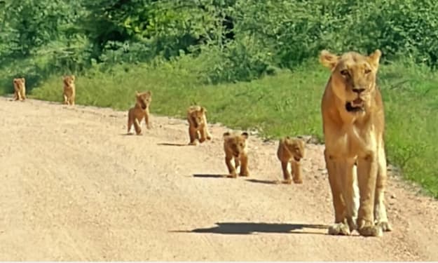
Tiny Lion Cubs Struggle To Keep Up With Mom
In the heart of the African savannah, life is a constant lesson for young animals. Few scenes are as endearing — or as heartwarming — as tiny lion cubs trying to keep pace with their mother. These little bundles of fur face a world full of challenges, from learning to hunt to avoiding dangers, all while depending on the guidance and protection of their experienced mom. Watching cubs wobble and tumble as they attempt to keep up with their mother reminds us that growing up, even in the wild, is a journey full of struggle, determination, and adorable missteps. The Early Days of Lion Cubs Lion cubs are born blind and helpless, usually in litters of two to six. For the first few weeks, they rely entirely on their mother for warmth, food, and safety. Even after opening their eyes and beginning to explore, the cubs are far from independent. The first months are crucial. Cubs learn social cues, hunting basics, and survival skills simply by watching their mother and the pride. But as anyone who has observed them knows, there’s often a huge gap between observation and action. Tiny cubs often struggle to match their mother’s pace, especially when she moves through long stretches of savannah or leads the family on patrols. A Mother’s Role in the Wild For a lioness, raising cubs is a full-time commitment. She hunts, defends her territory, and teaches her young, all while staying alert to predators such as hyenas, leopards, and even rival lions. The cubs, meanwhile, attempt to mimic her every move — often with clumsy yet charming results. A mother lion’s patience is remarkable; she frequently slows down, nudges them along, or stops to ensure no cub is left behind. These moments, while stressful for the tiny cubs, are vital learning opportunities. Struggling to Keep Up: Why It’s So Hard There are several reasons why tiny lion cubs have trouble keeping pace with their mother: Short Legs, Big Steps: Lion cubs’ legs are tiny and their coordination is limited, making it difficult to cover the same distance as an adult lioness. Curiosity: Cubs are naturally curious. A single butterfly or rustling bush can distract them, leaving mom to pause repeatedly. Energy Levels: Young lions tire quickly. Even with frequent naps, the cubs’ stamina is far lower than their mother’s. Learning Through Play: Play is not just fun; it teaches hunting, balance, and social skills. Running off to pounce on a sibling or chase an insect is all part of their education. Despite these challenges, the cubs’ determination to keep up demonstrates their resilience and growing understanding of the wild world. Lessons in Teamwork and Survival Every cub struggling to keep up is also learning crucial survival skills. The journey across the savannah is more than a test of speed — it’s a lesson in: Coordination: Cubs learn how to move efficiently across different terrains. Patience: They begin to understand the rhythms of adult life and the pace required for survival. Social Skills: Staying with the group teaches cubs how to interact with siblings and the pride, which is essential for their future roles. Observation: By following their mother, cubs study hunting techniques, territorial behavior, and predator awareness. Even the moments when cubs stumble or lag behind are essential for their development. These experiences prepare them for independence, which comes sooner than many might expect. The Cutest Moments in the Wild Anyone who has watched tiny lion cubs knows that their struggles are often irresistibly cute. Video clips from wildlife reserves frequently show cubs toddling along, tumbling over each other, or getting distracted mid-step. Observers often comment that these little stumbles reveal personality, determination, and playfulness, making them one of nature’s most heartwarming spectacles. While their mother is serious and focused, the cubs inject a sense of humor and lightness into life on the savannah. Why This Matters The struggles of lion cubs aren’t just adorable — they’re vital for understanding wildlife behavior. Conservationists and animal behaviorists use these moments to study growth patterns, social structures, and survival strategies in lion populations. These observations also highlight the importance of preserving natural habitats. Cubs must learn in a safe environment to survive; habitat loss, poaching, and climate change make these early struggles even more dangerous. Protecting the African savannah ensures that future generations of lions can experience the same lessons and playful tumbles. The Road to Independence Within a year, these tiny cubs will be more agile, faster, and more confident. By the time they reach two to three years old, males may begin to leave the pride, while females often stay and become caretakers themselves. Every misstep, tumble, and lagging moment is part of the journey toward strength, coordination, and independence. Watching them now gives us a glimpse of the challenges they will overcome, and the survival skills they will carry for life. A Celebration of Motherhood Ultimately, these scenes remind us of the incredible bond between mother and cubs. Her patience, vigilance, and teaching are the foundations of their future. The cubs’ struggles highlight the trials of growing up, while their determination showcases the resilience and beauty of wildlife. For those observing, it’s a powerful lesson in care, guidance, and perseverance, not just in lions but in the natural world as a whole. Final Thoughts Watching tiny lion cubs try to keep up with their mother is both entertaining and enlightening. It’s a story of growth, struggle, and resilience — a reminder that even the fiercest creatures start small, learning step by step. These little lions capture hearts while teaching life lessons: patience, determination, teamwork, and the importance of guidance. As they tumble and waddle across the savannah, they show us that growth is a process, one adorable misstep at a time. For wildlife enthusiasts, animal lovers, and anyone enchanted by nature, these tiny cubs are proof that even in the wild, love, care, and persistence are universal truths.
By Aarif Lashari2 days ago in Earth
Microbiota, microbiome or microflora: how to speak correctly and why it is for health.
You've probably heard the phrase, "We are what we eat." But modern science says more precisely: we are also those who live in us. Until 2016, it was believed that there are many times more bacteria in our body than our own cells. The latest calculations by mathematicians show that we divide the body with our microorganisms by about 50/50: about 30 trillion of our cells versus 38 trillion bacterial ones.
By Yaroslav Gorohov6 days ago in Earth


Comments
There are no comments for this story
Be the first to respond and start the conversation.