
Met Office Names All the UK Areas Facing Snow on Saturday and Sunday
Full list of regions at risk as wintry weather threatens travel disruption across Britain

The Met Office has confirmed that snow is likely to affect multiple parts of the UK this weekend, with cold air sweeping southwards and increasing the risk of wintry conditions on both Saturday and Sunday. Forecasters say a combination of falling temperatures and incoming weather systems could bring snow, sleet, and icy conditions, particularly across northern and central regions.
While not everyone will see heavy snowfall, the Met Office has identified key areas most at risk, prompting warnings for motorists, rail passengers, and local authorities preparing for winter disruption.
Why Snow Is Expected This Weekend
According to meteorologists, a shift in the jet stream is allowing colder Arctic air to move into the UK. As this cold air clashes with moisture from Atlantic weather fronts, precipitation is increasingly likely to fall as snow—especially overnight and in early morning hours.
Temperatures are forecast to dip close to or below freezing in many areas, creating conditions favourable for snowfall and ice, even at relatively low elevations.
UK Areas Facing Snow on Saturday
Scotland
Scotland is expected to experience the most widespread snowfall:
Scottish Highlands
Grampian region
Perthshire
Central Belt (particularly higher suburbs of Glasgow and Edinburgh)
Southern Uplands
Snow showers could be heavy at times, with drifting possible in exposed areas. Travel over high routes may be particularly challenging.
Northern England
Several northern English regions are on snow watch:
Cumbria, including the Lake District
Northumberland
Durham uplands
Pennines across North Yorkshire and Lancashire
Lower-lying towns may initially see rain or sleet before temperatures drop and snow develops later in the day or overnight.
Snow Risk Expands on Sunday
Colder air is expected to push further south on Sunday, widening the risk of snowfall.
Midlands
Parts of the Midlands could wake up to wintry conditions:
East Midlands
West Midlands (especially higher ground)
Derbyshire Peak District
Staffordshire Moorlands
Snowfall here is expected to be lighter and more patchy, but icy roads and pavements could still cause disruption.
Wales
Wales is also expected to see snow, particularly inland:
Snowdonia and higher ground in North Wales
Mid Wales uplands
South Wales Valleys
Coastal areas are more likely to experience cold rain or sleet, but inland communities may see temporary snow cover.
Southern England: Lower Risk but Still Possible
Southern England faces a more marginal risk, but the Met Office has not ruled out snow entirely.
Areas with a chance of wintry weather include:
Cotswolds
Chiltern Hills
Parts of the South Downs
Higher ground in Kent and Surrey
Here, temperatures are expected to be borderline, meaning snow may fall briefly before turning back to rain.
Travel and Disruption Warnings
The Met Office has advised people to prepare for:
Slippery roads and pavements
Reduced visibility during snow showers
Delays on rail and bus services
Increased risk of ice overnight
Local councils are planning gritting operations, particularly in regions where sub-zero temperatures are forecast. Rail operators have also warned that even light snow can cause knock-on delays, especially during early morning services.
How Much Snow Could Fall?
Forecasts suggest:
Several centimetres of snow on higher ground in Scotland and northern England
Temporary snow cover in parts of the Midlands and Wales
Light or fleeting snowfall further south
Meteorologists stress that small temperature changes could significantly affect how much snow falls, making updates likely as the weekend approaches.
Why UK Snow Forecasts Are Uncertain
Snow forecasting in the UK is notoriously difficult. A difference of just one or two degrees can determine whether precipitation falls as rain, sleet, or snow.
The Met Office is closely monitoring:
Ground temperatures
Wind direction
Timing and intensity of precipitation bands
Because of this, weather warnings may be upgraded or downgraded at short notice.
Advice for the Public
The Met Office recommends that people:
Check local forecasts regularly
Allow extra time for travel
Wear suitable footwear to reduce slip risk
Keep emergency supplies in vehicles
Drivers in rural and high-altitude areas are urged to be especially cautious, as conditions can deteriorate quickly.
What Happens After the Weekend?
Early forecasts suggest that cold conditions could persist into next week, though snowfall may become more isolated. Forecasters say confidence decreases further ahead, but wintery weather remains possible.
Conclusion
With snow forecast across large parts of the UK on both Saturday and Sunday, the Met Office is urging the public to stay alert and prepared. While not every region will see significant accumulation, wintry conditions could still cause disruption, particularly for travel and outdoor activities.
Keeping up to date with official forecasts and planning ahead will be key as winter weather makes a renewed appearance across the country.
About the Creator
Keep reading
More stories from Aarif Lashari and writers in Earth and other communities.
Met Office Names All the UK Areas Facing Snow This Weekend
The Met Office has issued fresh forecasts warning that snow is set to affect large parts of the UK this weekend, with wintry conditions expected to develop from Saturday and persist into Sunday. As colder air moves south and meets bands of moisture, forecasters say a mix of snow, sleet, and freezing rain could disrupt travel and daily life across multiple regions.
By Aarif Lashariabout 3 hours ago in Earth
Robert Redford Remembered for His Mentorship of New Filmmakers at Sundance Gala
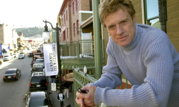
At this year’s Sundance Film Festival gala, the spotlight turned to Robert Redford, not only as a legendary actor and filmmaker but as a mentor who nurtured countless emerging talents. Attendees, including directors, producers, and actors, shared heartfelt stories about how Redford’s guidance transformed their careers and inspired a new generation of filmmakers. A Legacy Beyond Acting Robert Redford’s career in Hollywood spanned decades, with iconic roles in films like Butch Cassidy and the Sundance Kid, All the President’s Men, and The Sting. However, his impact extends far beyond the screen. As the founder of the Sundance Institute, Redford created a platform that championed independent voices, giving filmmakers the opportunity to explore creative freedom without the constraints of major studios. At the gala, festival director Tabitha Jackson remarked, “Redford didn’t just make films; he made futures. He believed in new voices long before they had a platform.” This sentiment resonated with many in attendance who credited their breakthroughs to Redford’s mentorship. Mentorship Through the Sundance Institute Founded in 1981, the Sundance Institute was born out of Redford’s vision to support independent filmmaking. Over the years, the institute has: Offered labs, workshops, and grants to new filmmakers. Provided mentorship from established directors and industry professionals. Created a global platform for storytelling through the Sundance Film Festival, now recognized as one of the premier venues for independent cinema. Several filmmakers who attended the gala recounted how Redford personally encouraged them to take creative risks, even when their ideas seemed unconventional. His approach emphasized storytelling authenticity over commercial considerations, a principle that has influenced countless careers. Voices From the Gala Emerging filmmakers at the event shared touching memories of Redford’s influence: Director Maya Johnson recalled how Redford reviewed her early short film and offered constructive advice, helping her refine her narrative voice. Producer Alex Chen highlighted Redford’s commitment to inclusive storytelling, encouraging him to amplify underrepresented voices in cinema. Actor Lila Martinez reflected on the actor-director’s ability to instill confidence in new talent, reminding them that their perspective mattered. These personal testimonies painted a portrait of Redford not only as an industry icon but as a guiding presence committed to cultivating the next generation of storytellers. Redford’s Philosophy on Filmmaking Redford often spoke about the importance of creativity, authenticity, and collaboration in filmmaking: Creativity over commerce: He encouraged filmmakers to prioritize artistic integrity. Mentorship as legacy: Redford believed sharing knowledge was key to sustaining the art form. Risk-taking: He frequently reminded young directors that innovation comes from challenging norms and exploring new perspectives. These principles remain at the heart of the Sundance Institute and the broader independent film community. The Global Influence of Sundance Thanks to Redford, Sundance has become a global platform for independent cinema, with programs reaching filmmakers in Europe, Asia, Africa, and Latin America. Through labs, festivals, and initiatives, Redford’s influence extended far beyond the U.S., helping shape a diverse, international community of filmmakers. Sundance alumni have gone on to create films that have won Oscars, Golden Globes, and international awards, underscoring Redford’s impact on the global film industry. Honoring Redford’s Legacy The gala featured a tribute montage highlighting Redford’s contributions as an actor, director, and mentor. Clips included moments of him guiding young filmmakers, presenting awards, and reflecting on his own journey in the industry. Many attendees emphasized that Redford’s greatest legacy may not be his iconic films, but the careers he helped launch. Festival director Jackson noted, “Every filmmaker here carries a piece of Robert’s wisdom. His mentorship continues to ripple through every frame of independent cinema.” Redford and the Future of Independent Filmmaking As the independent film landscape evolves—with streaming platforms, AI tools, and global collaboration becoming more prevalent—the foundations laid by Redford and Sundance remain vital. His mentorship model demonstrates that investing in people and ideas creates lasting cultural impact, ensuring that independent voices continue to thrive. Emerging filmmaker Jordan Reyes commented, “Redford taught me that every story has value. That lesson shapes how I create and support others in my community today.” Personal Reflections and Anecdotes Many festival attendees shared anecdotes reflecting Redford’s humility, approachability, and passion for storytelling: Despite his fame, he would sit in small discussion circles with young filmmakers, offering advice and encouragement. He often hosted informal gatherings at his homes or lodges, creating spaces where filmmakers could network, learn, and experiment. His presence at Sundance was consistently an inspiration to those navigating the challenges of independent filmmaking, providing mentorship that was practical, emotional, and motivational. These stories underscored that Redford’s mentorship was not just professional—it was personal and transformative. Final Thoughts Robert Redford’s remembrance at the Sundance gala served as a celebration of mentorship, vision, and the power of independent cinema. Beyond the accolades and cinematic achievements, his enduring legacy lies in the careers he nurtured, the voices he amplified, and the creative risks he inspired. The festival’s message was clear: while Redford may no longer be present in every Sundance discussion, his influence lives on through the filmmakers he mentored, ensuring that independent storytelling continues to thrive, evolve, and inspire future generations. For the community of filmmakers, audiences, and cinema lovers worldwide, Redford’s legacy remains a beacon of mentorship, creativity, and dedication to storytelling.
By Muhammad Hassan7 days ago in Earth


Comments
There are no comments for this story
Be the first to respond and start the conversation.