
Massive Winter Storm Sweeps Across the U.S., Bringing Record Snow and Bitter Cold
"Polar Vortex Unleashes Record Snowfall, Freezing Temperatures, and Travel Chaos Across the U.S."

Millions of Americans are bracing for a powerful winter storm that threatens to deliver record-breaking snowfall, icy conditions, and dangerously low temperatures across much of the United States. States like Kansas, Arkansas, Kentucky, and Virginia have declared states of emergency as the storm, powered by a polar vortex, moves eastward after impacting the central U.S.
What Is a Polar Vortex?
A polar vortex is an area of cold air and low pressure that spins near the Earth’s poles. Occasionally, part of this system shifts southward, bringing frigid Arctic air into regions like North America. This phenomenon is now driving extreme winter weather across the U.S., with the National Weather Service (NWS) issuing alerts for 30 states.
Widespread Weather Alerts
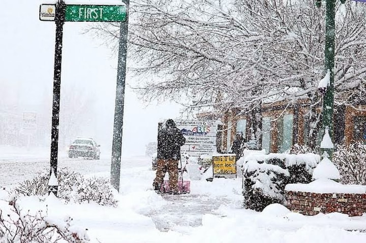
As of Sunday, around 60 million people across the Plains, Midwest, and mid-Atlantic are under weather alerts. The NWS predicts historic snowfall for northeastern Kansas and north-central Missouri, with accumulations exceeding 15 inches—the heaviest in a decade. Blizzard warnings are in place for these regions, where strong winds and reduced visibility are making travel nearly impossible.
Meanwhile, southern states like Mississippi and Louisiana are preparing for severe thunderstorms, hail, and potential tornadoes. These regions, unaccustomed to extreme cold, are also issuing warnings about icy roads and freezing conditions.
Travel Disruptions and Preparations
The storm has already caused significant travel disruptions. Kansas City International Airport temporarily closed on Saturday, delaying dozens of flights, including one carrying the Kansas City Chiefs. Additionally, an 18-mile stretch of Interstate 70 in Kansas was shut down as snow and winds created dangerous conditions.
Airports across the country are feeling the impact, with nearly 7,000 weather-related flight delays reported on Saturday. Denver International Airport saw nearly half of its scheduled departures delayed. Major airlines like American, Delta, Southwest, and United are waiving change fees in anticipation of further disruptions.
Cities like Chicago, St. Louis, and Cincinnati have prepared for the storm by treating roads and setting up warming centers to help residents deal with the freezing conditions.
The Storm’s Path
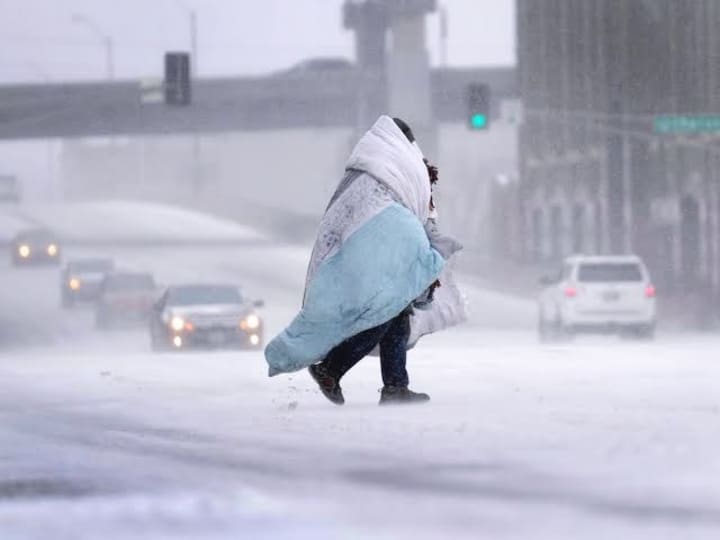
The storm will bring snow and ice to the mid-Atlantic and central Appalachian regions starting Sunday night and continuing through Monday. Washington, D.C., Baltimore, and Philadelphia are expected to see significant snowfall, with parts of Virginia anticipating between 5 and 12 inches. Snow showers will taper off by Tuesday as the system moves offshore.
Extreme Cold to Follow
As the storm passes, a significant drop in temperatures will grip the eastern two-thirds of the country. Highs are expected to plummet 10 to 25 degrees below average, with the northern Plains experiencing the most severe cold. Overnight lows could reach minus 20, with wind chill values dipping to a bone-chilling minus 40.
Staying Safe
Authorities are urging residents to stay indoors, avoid travel if possible, and prepare for potential power outages. Dangerous road conditions, reduced visibility, and extreme cold pose serious risks in the coming days. Warming centers have been set up in affected areas to help those in need, while officials continue to monitor the storm’s progress.
This historic winter storm is a reminder of the power of nature and the importance of preparation. As millions brace for its impact, communities are coming together to face the challenges of the bitter cold, heavy snow, and icy conditions.
About the Creator
Myanmar Junta Holds Second Phase of Election Widely Decried as a ‘Sham Exercise’
If you’ve been following Myanmar’s political turmoil, you probably heard the news: the military junta just held the second phase of its general election, and once again, critics are calling it a “sham exercise.” From the United Nations to human rights organizations, almost everyone outside the junta is dismissing this vote as a carefully orchestrated performance rather than a genuine democratic process. Let’s take a closer look at what happened, why it’s being condemned, and what this means for Myanmar’s future. A Military-Run Election in a Nation at War On 11 January 2026, voters in certain parts of Myanmar lined up at polling stations to cast their ballots in the second phase of the election. This phase covered roughly 100 townships across 12 states and regions, part of a three-phase plan that began in December 2025 and will conclude in late January. Sounds orderly enough—but here’s the catch: large areas of Myanmar are still controlled by armed opposition groups or trapped in active conflict zones. In many townships, voting didn’t even happen because it was too dangerous. For millions of citizens, the idea of participating in this election isn’t about choice—it’s about survival. So, while the junta presents this as a return to political normalcy, the reality is much messier. This vote is happening amid ongoing civil war, instability, and widespread human suffering. Who’s on the Ballot? And Who Isn’t One of the biggest issues with this election is who is allowed to run. Aung San Suu Kyi’s National League for Democracy (NLD)—the party that won a landslide in the 2020 election—is banned. Suu Kyi herself remains detained on politically motivated charges. Many smaller opposition parties have also been barred from participating. Rebel groups and youth movements have refused to take part, calling the vote illegitimate. This has left the military-backed Union Solidarity and Development Party (USDP) as the clear front-runner. In the first phase of voting in December, the USDP already secured nearly 90 of 102 contested seats, which is a strong indicator that the outcome of the overall election is practically predetermined. In short, this is less an election and more a political tool for the junta to cement power. The Junta’s Playbook For the military, these elections serve multiple purposes: Legitimacy: By holding elections, the junta hopes to claim that it has public support. Control: With opposition parties banned, the military ensures it dominates Parliament. International Image: They want the world to see a functioning democratic process—even if it’s staged. But the global community isn’t buying it. The United Nations, human rights organizations, and most Western governments have condemned the elections as neither free nor fair. Key issues include: Widespread political repression Absence of meaningful opposition Election laws that stifle dissent Unsafe conditions for voters UN Special Rapporteur Tom Andrews even warned that the elections “cannot and should not be recognized” internationally. Voices from the Ground: Fear, Frustration, and Exclusion For everyday citizens, voting is complicated. Many are intimidated or fear retribution if they don’t comply. Others live in conflict zones or have been displaced, making voting physically impossible. Ethnic groups and youth activists are particularly vocal about rejecting the elections. For them, the vote is a tool to marginalize minority communities and entrench military rule. Meanwhile, ordinary voters express mixed feelings—some participate out of hope for peace, others because they feel they have no choice. The reality? The election process is fragmented, forced, and disconnected from the lives of most Burmese citizens. International Reactions: Mostly Negative Around the world, reaction to Myanmar’s elections has been overwhelmingly critical. The UN, Western governments, and human rights organizations argue that the polls are designed to prop up an authoritarian regime, not reflect the will of the people. Civil society groups in Asia have also condemned the election, urging countries not to recognize the results. The junta’s international supporters, however—countries like China and Russia—may continue diplomatic engagement, making it harder to isolate the regime completely. The key takeaway? While the junta may claim legitimacy, global acceptance is far from guaranteed. Looking Ahead: What Happens Next? The final phase of voting is scheduled for 25 January 2026, and it’s expected to follow the same patterns: military dominance, restricted opposition, and contested legitimacy. If the junta consolidates power through this election, it will likely form a government that appears “elected” on paper but remains authoritarian in practice. Yet the ongoing civil war, international criticism, and domestic opposition suggest that Myanmar’s road to stability is still far away. For observers inside and outside the country, these elections are less about democracy and more about power. The military hopes to create a façade of legitimacy, but the reality on the ground tells a very different story: one of fear, division, and a population yearning for genuine representation.This blog version is more readable, flows naturally, and keeps the key facts intact, while meeting Vocal Media’s style of a narrative, accessible, and conversational article. If you want, I can also add a sidebar timeline showing all three phases of Myanmar’s 2025–26 elections to make it extra engaging for readers. It would fit perfectly for a blog format. Do you want me to do that? Conclusion Myanmar’s second-phase election may look like a step toward democracy on paper, but in reality, it’s a highly controlled, military-managed process with limited participation and credibility. With opposition voices silenced, ongoing conflict, and millions of citizens excluded, the so-called vote is widely regarded as a sham exercise. For the people of Myanmar, the future remains uncertain. While the junta may claim victory, the country’s deep political, social, and ethnic fractures mean that true democracy and stability are still a long way off. This election is a reminder that sometimes, the act of voting alone doesn’t equal democracy—especially when freedom, fairness, and choice are nowhere to be found.
By Muhammad Hassan6 days ago in Earth
Inflation Remained at 2.7% in December: High Prices Continue to Weigh on Many Americans
As Americans rang in the new year, many were relieved to see that inflation in December held steady at 2.7%, according to the latest reports. On the surface, this might seem like good news — a signal that runaway price growth is slowing. But for countless households across the country, the reality is more complicated: high prices continue to strain budgets, affecting everything from groceries to gas, rent, and beyond. The Numbers Behind the Headlines December’s 2.7% inflation rate, measured year-over-year, shows no significant change from November. This is a continuation of the trend economists have watched closely throughout 2025: after a period of intense price spikes, inflation appears to be moderating but remaining stubbornly above pre-pandemic norms. Key areas contributing to this steady inflation include: Food prices, particularly meat, dairy, and fresh produce, which have remained elevated due to supply chain challenges and global agricultural pressures. Housing costs, including rents and home prices, which continue to rise in many urban and suburban markets. Energy prices, especially gasoline and home heating, which fluctuate seasonally but have not dropped enough to ease household pressure. While 2.7% may seem manageable compared to the double-digit spikes of 2021–2022, it still outpaces wage growth for millions of Americans, meaning that in real terms, many are experiencing reduced purchasing power. How Inflation Affects Everyday Americans For many families, the impact of steady inflation is tangible. Consider this: a household spending $500 a month on groceries in 2025 might now be paying over $535 for the same items. Gasoline, which has seen seasonal swings, can quickly add dozens of dollars to monthly commuting costs. Rent, historically the largest expense for most households, has grown faster than wages in many cities. A steady 2.7% inflation rate means renters face incremental increases in living costs every month, often outpacing salary adjustments. Even seemingly small price increases ripple across budgets. Families may delay purchases, cut discretionary spending, or tap savings, which in turn affects broader consumer demand — a key driver of economic growth. The Role of the Federal Reserve and Economic Policy Inflation is not just about prices at the grocery store — it’s also shaped by monetary policy, interest rates, and government action. Throughout 2025, the Federal Reserve maintained a cautious approach, keeping interest rates relatively high to control inflation without triggering a recession. The Fed’s actions aim to balance: Slowing price growth to protect consumers’ purchasing power Avoiding a sharp economic downturn that could result from overly aggressive rate hikes Despite these efforts, economists warn that inflation’s persistence at 2.7% suggests structural pressures in the economy. Global supply chain disruptions, rising energy costs, and ongoing demand for goods and services continue to exert upward pressure on prices, making it harder for policy alone to bring relief. Inflation and Wage Growth: A Delicate Balance One of the most concerning aspects of steady inflation is its relationship with wages. For workers whose salaries haven’t kept pace with rising costs, inflation effectively reduces real income. Some sectors, like technology and healthcare, have seen modest wage gains, but many service industries — retail, hospitality, and small businesses — continue to struggle. Employees in these fields often find that even small price increases can significantly affect their quality of life, from grocery shopping to transportation and childcare expenses. What This Means for the Economy Steady inflation at 2.7% has several implications for the broader economy: Consumer Spending: When households feel the pinch, discretionary spending declines, which can slow economic growth. Investment Decisions: Businesses facing higher input costs may delay expansion or hiring, affecting job markets. Housing Market Dynamics: Rising rent and home prices continue to challenge affordability, influencing both buyers and renters. Financial Planning: Americans are increasingly turning to budgeting strategies, high-yield savings, or side income to offset higher costs. Economists stress that while inflation at this level is not catastrophic, it remains a long-term concern, especially if wages fail to keep up with price growth. Strategies for Coping with Persistent Inflation For households navigating these pressures, there are several approaches: Budget adjustments: Tracking expenses and prioritizing essential costs can help manage monthly finances. Smart shopping: Using discounts, bulk purchasing, and price comparison can reduce grocery and household costs. Energy efficiency: Lowering utility bills through energy-saving practices mitigates rising energy prices. Financial literacy: Investments, savings, and debt management become even more crucial in times of persistent inflation. While these steps cannot eliminate inflation’s impact, they provide tangible ways for Americans to protect their finances. Looking Ahead Economists predict that inflation in 2026 may continue to hover around 2–3%, barring unexpected shocks such as global conflicts, energy crises, or supply chain disruptions. While not extreme, this range continues to influence household budgets, corporate planning, and government policy decisions. For many Americans, the lesson is clear: even modest inflation can weigh heavily on day-to-day life. Staying informed, adjusting financial habits, and understanding the economic landscape remain essential for navigating a world where prices are higher than before. Steady inflation at 2.7% is a reminder that economic stability is fragile. While the numbers suggest moderation, the lived experience of millions of Americans shows that high prices are far from over, influencing decisions from grocery shopping to career planning. As the new year unfolds, households, businesses, and policymakers alike must grapple with the realities of an economy where every percentage point matters.
By Muhammad Hassan4 days ago in Earth
Miss Persephone's Manual to a Seemingly Ordinary Life
Miss Persephone was found at the dining table, her blue eyes swollen, her tears arriving and retreating like the tides of the ocean. Earlier that day, her family had visited her in the retirement home where she had lived for eight years. It was her eightieth birthday.
By Imola Tótha day ago in Fiction


Comments
There are no comments for this story
Be the first to respond and start the conversation.