
Hurricane Helene Strikes Florida’s Big Bend as a Devastating Category 4 Storm
"Category 4 Hurricane Helene Hits Florida’s Big Bend, Bringing Destructive Storm Surges and Widespread Power Outages"
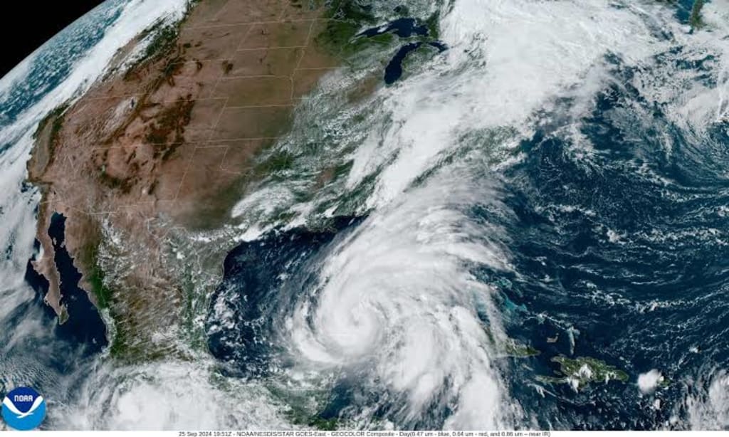
Hurricane Helene made a dangerous landfall in Florida's Big Bend area late Thursday night, bringing life-threatening storm surges, powerful winds, and widespread damage. The National Hurricane Center had already warned that the storm could be "catastrophic and deadly," with storm surges reaching as high as 20 feet in certain areas. As Helene moved through the Gulf of Mexico, it quickly intensified into a Category 4 storm with winds of 140 mph.
Landfall Near Perry, Florida
Helene made landfall near Perry, Florida, shortly after 11:20 p.m. Eastern Time. With sustained winds of 140 mph, the storm hit with tremendous force, flooding roads, damaging homes, and leaving a path of destruction in its wake. CBS News senior weather and climate producer David Parkinson reported that the storm’s surge, combined with heavy rainfall, made conditions especially dangerous for those who had not yet evacuated.
Ben Brennan, a meteorologist with the National Hurricane Center, warned that the storm surge could cause massive destruction. "That kind of water level can destroy houses, move cars, and rise quickly, cutting off escape routes," Brennan explained.
Widespread Power Outages
As of Thursday night, more than 885,000 customers in Florida were already without power, according to PowerOutage.us, a utility tracker monitoring outages. Power lines were knocked down by the strong winds, and recovery teams are expected to work around the clock to restore power once conditions improve.
A Dangerous and Rapidly Strengthening Storm
Helene strengthened throughout the day on Thursday, quickly turning into what the National Hurricane Center described as "an extremely dangerous Category 4 hurricane." At 11 p.m. Eastern Time, Helene was located about 75 miles northwest of Cedar Key, Florida, and 40 miles southeast of Tallahassee.
The hurricane's outer bands had already started affecting Florida’s west coast by Thursday morning, bringing heavy rains and flooding to many areas. In the Big Bend region, Gulf waters spilled over barriers, causing roadways to flood. St. Petersburg saw record storm surges, while Tampa—on the backside of the storm—was expected to see conditions improve as Helene moved further inland.
The Storm's Path
After making landfall, Helene was expected to move inland over Georgia, bringing the potential for significant flooding in the Southeast. Forecasts predicted as much as 10-20 inches of rain in the southern Appalachian Mountains, while Atlanta could see around six inches of rain. Winds in Atlanta were expected to reach tropical storm force early Friday morning, but should start to die down by mid-morning.
As the storm continues inland, states further north will also need to be prepared for heavy rains, flooding, and potential damage. While Florida will likely see the most severe impact, Helene’s path will bring hazardous conditions to parts of Georgia and the Carolinas as well.

Warnings From Officials
Florida Governor Ron DeSantis issued urgent warnings to residents in high-risk areas, urging them to move to higher ground immediately. “Every minute that goes by brings us closer to having conditions that are going to be simply too dangerous to navigate," DeSantis cautioned.
At the federal level, the head of the Federal Emergency Management Agency (FEMA), Deanne Criswell, stressed the importance of heeding storm surge warnings. She reminded people that storm surge is the number one cause of death in hurricanes, and shared that most of the 150 people who died during Hurricane Ian in 2022 lost their lives due to drowning.
Criswell emphasized that people don’t need to travel far to avoid the worst impacts of a storm surge. “Remember that you may only need to go 10 or 15 miles inland to get away from the threat of the storm surge itself," she said. "Please don’t underestimate what the impacts could possibly be."
A Reminder of Hurricane Ian’s Deadly Legacy
Officials were quick to draw comparisons to Hurricane Ian, which devastated Florida in 2022. Many of those who died during Ian’s onslaught were victims of storm surge and flooding, leading authorities to take a more aggressive approach in warning people about the dangers this time around.
FEMA and local officials have been working to ensure that residents in Helene’s path are fully aware of the risks, especially in vulnerable coastal areas. While evacuation orders had been issued for days leading up to the storm’s arrival, some residents chose to stay behind, despite the warnings.
The Importance of Staying Safe
As Hurricane Helene continues to push inland, Florida residents are urged to stay indoors and avoid venturing out into dangerous conditions. While winds may calm temporarily, particularly if the eye of the storm passes overhead, conditions will worsen again once the other side of the storm arrives.
For those who have already evacuated or sought higher ground, the next few hours and days will be critical in determining when it's safe to return home. As always, the safety of residents and first responders remains the top priority, and officials will continue to monitor the storm and provide updates as more information becomes available.
Conclusion
Hurricane Helene’s landfall in Florida’s Big Bend has already proven to be a major disaster, bringing high winds, storm surges, and flooding to much of the state. With hundreds of thousands of people without power and conditions still worsening, residents are reminded to stay safe, follow evacuation orders, and take the storm’s risks seriously. Helene's impact will likely be felt for days to come, both in Florida and beyond as the storm moves through the Southeast.
About the Creator
UK must double down on renewables as wars drive up energy costs, experts say
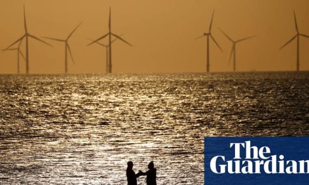
Britain must accelerate its transition toward renewable energy sources as geopolitical conflicts continue to drive global energy prices higher, according to leading energy analysts and climate policy experts. The warning comes as wars and political tensions across key energy-producing regions expose the vulnerability of countries still heavily reliant on imported fossil fuels. In recent years, the United Kingdom has made significant progress expanding renewable energy capacity, particularly in offshore wind and solar power. However, experts argue that the pace of the transition remains insufficient to shield the country from the volatility of international energy markets. Conflicts in the Middle East and Eastern Europe have demonstrated how quickly supply disruptions can translate into rising costs for households and businesses. Energy economists say the lesson from recent global crises is clear: the more dependent a country is on imported oil and gas, the more exposed it becomes to geopolitical shocks. Britain imports a substantial portion of its natural gas and refined fuel products, meaning instability in global supply chains can quickly affect domestic energy bills. During periods of international conflict, oil prices often spike due to fears that shipping routes or production facilities could be disrupted. Even rumors of attacks near key energy chokepoints — such as major pipelines or shipping lanes — can cause markets to react sharply. These fluctuations, analysts say, ultimately filter down to consumers through higher electricity and heating costs. Renewable energy sources offer a potential solution to this problem because they rely on domestic resources such as wind and sunlight rather than imported fuels. Once renewable infrastructure is built, operating costs remain relatively stable because there is no need to purchase fuel on global markets. The United Kingdom already operates some of the world’s largest offshore wind farms, and renewable energy now accounts for a significant share of the country’s electricity generation. Government data indicates that wind power alone has become one of the largest sources of electricity in Britain, particularly during periods of strong weather conditions. Despite this progress, energy specialists argue that further investment is essential. Expanding renewable generation capacity requires not only building more wind and solar farms but also upgrading the national electricity grid. A modernized grid would allow energy produced in remote offshore locations to be transmitted efficiently to cities and industrial centers. Energy storage is another critical piece of the puzzle. Because renewable sources like wind and solar are intermittent, large-scale battery systems or alternative storage technologies are needed to ensure a stable supply of electricity during periods when generation drops. Developing these systems will require both technological innovation and sustained financial investment. Some experts also emphasize the importance of diversifying the country’s renewable portfolio. While offshore wind remains a cornerstone of Britain’s energy strategy, solar power, tidal energy, and green hydrogen could also play important roles in the future energy mix. The government has already announced plans to increase renewable capacity dramatically over the next decade. Officials argue that reducing reliance on fossil fuels will not only strengthen national energy security but also help the country meet its climate targets. However, critics say policy uncertainty and slow planning approvals have sometimes delayed renewable projects. Industry leaders have urged authorities to streamline regulatory processes and provide clearer long-term incentives for investors. For many analysts, the link between energy security and climate policy has never been more obvious. Wars and geopolitical tensions have shown that fossil fuel dependence can create economic vulnerability, while domestically produced renewable energy offers greater stability. “The global energy system is changing,” said one energy policy researcher. “Countries that invest early in renewable infrastructure will be better protected from geopolitical shocks and price spikes.” As international conflicts continue to reshape global energy markets, the debate over Britain’s energy future is likely to intensify. For supporters of renewable power, the current moment represents both a warning and an opportunity — a chance to accelerate the transition toward a more secure and sustainable energy system.
By Fiaz Ahmed 3 days ago in Earth
Two Grumpy Old Men Solve the Problem
Marty and Steve were two grumpy old men who lived together. They had known each other for years. Marty had been a bachelor all his life. Steve said it was because no one could stand to ever live with. Marty’s standard reply was “Well, you are, so what sort of a moron does that make you!”
By Calvin London5 days ago in Humor


Comments
There are no comments for this story
Be the first to respond and start the conversation.