
A Notable Storm: Tempête Benjamin and Its Powerful Winds
Tempête Benjamin and Its Powerful Winds: France Faces a Fierce Autumn Storm How a sudden low-pressure system unleashed chaos across the Atlantic coast and beyond

During the night of October 22 to 23, 2025, Tempête Benjamin (Storm Benjamin) struck France with remarkable intensity, bringing violent winds and gusts that exceeded forecasts in several regions.
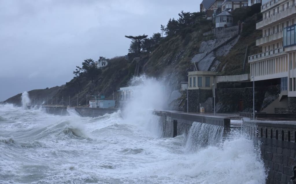
According to Météo-France, 19 departments were placed under orange alert for strong winds, heavy rain, or coastal flooding. On the Atlantic coast and along the English Channel, wind gusts reached 100 to 130 km/h, and in some exposed areas — especially Cap Corse — speeds of up to 160–170 km/h were recorded.
Where Were the Strongest Winds?
Coastal areas: Gusts reached 140 km/h along the Atlantic and Channel shores.
Inland regions and highlands: Areas such as Isère experienced winds up to 95 km/h in the plains and around 120 km/h on elevated plateaus like Ardèche.
Corsica: The island recorded some of the most violent gusts, reaching 160–170 km/h.
The Jura, Ain, and Haute-Loire regions: Reported winds of 100 km/h or more on mountain ridges.
These variations highlight that while the coastlines are typically most exposed, inland and mountainous regions were not spared from Benjamin’s force.
Why Were the Winds So Intense?
Several meteorological factors combined to create the strength of Tempête Benjamin’s winds:
A deep low-pressure system over the North Sea and the English Channel intensified rapidly, creating a steep pressure gradient — the key driver of strong surface winds.
Cold air masses moving in behind the storm front reinforced the westerly and northwesterly winds across the Atlantic coast and northern France.
Topography played a major role: valleys and mountain passes accelerated the winds, amplifying their impact in regions like Ardèche, Jura, and Corsica.
The storm also generated dangerous coastal conditions, with huge waves and significant risks of coastal flooding along vulnerable shorelines.
Impacts and Warnings
Tempête Benjamin’s passage left a range of disruptions and damages across the country:
Coastal flooding and high waves were reported in the Gironde, Landes, and Pyrénées-Atlantiques areas.
Fallen trees, power outages, and roof damage occurred in several departments due to wind intensity.
Rail transport faced delays and suspensions — especially local TER lines — as authorities prioritized safety in affected regions.
Authorities urged residents to remain cautious, particularly in the western and southern regions, where the wind’s force was strongest.
Staying Safe During Extreme Winds
Residents were advised to follow key safety precautions during and after the storm:
Avoid unnecessary travel, especially in wooded or coastal areas.
Keep vehicles away from trees and unstable structures.
Secure outdoor objects that could become airborne.
Stay away from seafronts, piers, or breakwaters — rogue waves can be deadly.
Follow Météo-France bulletins and official emergency alerts.
Such measures are vital to reducing the risk of injury or property damage during future storms.
Conclusion: A Reminder of Nature’s Power
Tempête Benjamin will be remembered as one of the most intense storms of autumn 2025, showcasing the raw power of nature and the unpredictability of modern weather systems. Its widespread impact — from coastal flooding to inland wind damage — highlights the need for continued vigilance and preparedness.
As climate patterns shift, France and other European countries may face more frequent and intense storms. Learning from Benjamin’s fury can help communities strengthen their resilience against future extreme weather events.
FAQs About Tempête Benjamin
1. What is Tempête Benjamin?
Tempête Benjamin is the name given to a powerful autumn storm that struck France in October 2025, bringing violent winds, rain, and flooding.
2. How strong were the winds during Tempête Benjamin?
Wind gusts reached between 100 and 130 km/h in many areas, with up to 170 km/h recorded in Corsica and along parts of the Atlantic coast.
3. Which areas were most affected?
The worst-hit regions included Brittany, Normandy, Corsica, and parts of southwestern France, though many inland areas also experienced strong gusts.
4. Was Tempête Benjamin caused by climate change?
While one storm alone cannot be blamed entirely on climate change, scientists note that warmer oceans and shifting pressure systems are making such extreme storms more frequent and intense.
5. How can residents prepare for future storms?
By staying informed through Météo-France alerts, securing outdoor items, and avoiding travel during peak winds, residents can significantly reduce risks during future events.
About the Creator
Asad Ali
I'm Asad Ali, a passionate blogger with 3 years of experience creating engaging and informative content across various niches. I specialize in crafting SEO-friendly articles that drive traffic and deliver value to readers.
How Does a Wildfire Sprinkler System Work to Protect Homes from Advancing Fires?
Wildfires have become an increasing concern in many regions where dry vegetation, strong winds, and high temperatures create conditions that allow fires to spread quickly. Homeowners in wildfire-prone areas are now turning to proactive protection systems designed to reduce risk and improve property resilience. Among these solutions, wildfire sprinkler systems are gaining attention for their ability to defend structures before flames reach them.
By Brandon Honeya day ago in Earth


Comments
There are no comments for this story
Be the first to respond and start the conversation.