Mountains Curve
Bio
I’m a passionate traveler with an insatiable curiosity for exploring new corners of the world. Beyond my love for adventure, I find joy in DIY crafts, cooking, planting, spending time in forests, and diving into anything new to learn.
Stories (18)
Filter by community
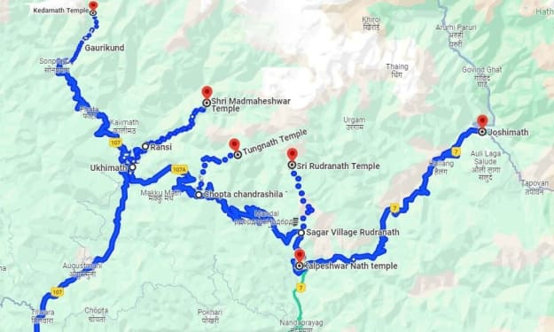
Panch Kedar Map: A Detailed Route Map of Panch Kedar Temples Yatra
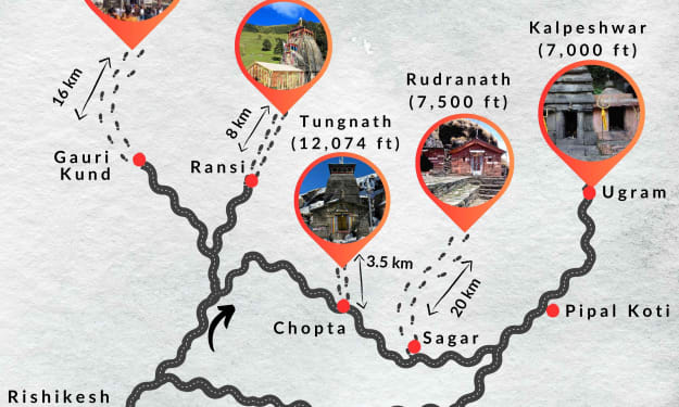
Panch Kedar refers to five Hindu temples dedicated to Lord Shiva. The Panch Kedar Map serves as a spiritual compass for devotees and trekking enthusiasts alike, offering a detailed guide to navigating the sacred pilgrimage to the five revered Panch Kedar Temples. This transformative journey takes pilgrims through awe-inspiring Himalayan landscapes, challenging terrains, and tranquil villages. The Panch Kedar Yatra is not only a test of physical endurance but also a deeply spiritual exploration steeped in Hindu mythology. With an outlined Panch Kedar Itinerary, the pilgrimage begins at Rishikesh and unfolds across Kedarnath, Tungnath, Rudranath, Madhyamaheshwar, and concludes at Kalpeshwar, providing unparalleled views of snow-capped peaks, pristine meadows, and dense forests.
By Mountains Curveabout a year ago in Journal
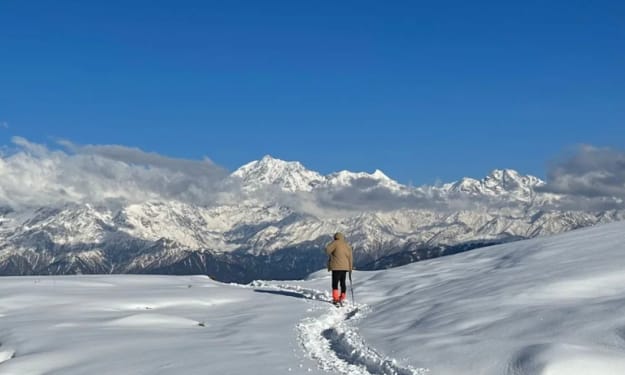
Top 5 Best Winter Treks in Uttarakhand
Are you an adventure enthusiast eager to experience the magic of snow treks? If so, Uttarakhand is your paradise! With its snow-clad mountains, scenic landscapes, and thrilling trails, Uttarakhand offers some of the best winter treks in India. Whether you are a seasoned trekker or a beginner, these treks in December provide the perfect mix of challenge and beauty. Winter treks in Uttarakhand are not just about pristine snow-covered trails and breathtaking views of the Himalayas but also about transformative journeys that challenge you physically and mentally. The shivering cold winds from the Himalayas, the crunch of snow under your boots, and the mesmerizing views of snow-laden forests and peaks make these treks an experience of a lifetime. Despite the challenges of numb soles and grinding teeth, the sheer beauty of these trails will keep you yearning for more. Uttarakhand’s winter treks promise an unforgettable journey through nature’s winter wonderland, leaving you with a sense of accomplishment and magical landscapes to cherish forever.
By Mountains Curveabout a year ago in Journal
Dayara Bugyal: All You Need to Know
Dayara Bugyal is one of the most picturesque alpine meadows in Uttarkashi, Uttarakhand. Known for its lush greenery, panoramic views of the Himalayas, and serene ambiance, it is a popular destination for trekking enthusiasts and nature lovers. Here is a detailed guide to help you explore this pristine gem.
By Mountains Curveabout a year ago in Journal
The Enchanting Journey Through Panch Kedar: A Spiritual Trek in the Himalayas
The state of Uttarakhand, often called “Devbhoomi” (the Land of Gods), has been a sacred abode for divine beings since ancient times. Among the numerous revered sites, the Panch Kedar temples hold a special place in the hearts of Shiva devotees. These five ancient temples dedicated to Lord Shiva—Kedarnath, Tungnath, Madhmaheshwar (Madhyamaheshwar), Rudranath, and Kalpeshwar—are nestled in the Kedarkhand region (केदारखंड क्षेत्र) of the Garhwal Himalayas.
By Mountains Curveabout a year ago in Journal
Dayara Bugyal Trek Distance and Time: All You Need to Know
The Dayara Bugyal Trek is widely regarded as the most beginner-friendly and multi-day hiking trail located in the Uttarkashi district of Uttarakhand. Being one of the best winter treks in Uttarakhand, and with its lush meadows, stunning Himalayan views, and moderate difficulty, it’s perfect for trekkers of all ages. Understanding the trekking distance of each day is essential to plan your fitness and journey effectively.
By Mountains Curveabout a year ago in Lifehack
How Dayara Bugyal Temperature Shapes Your Trek Experience. AI-Generated.
Dayara Bugyal Trek is the best beginner-friendly and multi-day hiking trail located in the Uttarkashi district of Uttarakhand. It’s an all-time favorite meadow trek that can be done in all seasons of the year. Starting from Raithal Village (1800m), it’s a gradual ascent of a 10 km long trail, which takes about 2–3 days to reach the top of Dayara Bugyal at the highest altitude of 3,657m (12,000 ft) above sea level.
By Mountains Curveabout a year ago in Lifehack