
Where Is Puglia Italy on a Map With Towns
Where Is Puglia Italy on a Map


You open Google Maps, zoom into Italy, and suddenly you are squinting. Town names everywhere. Coastlines bending. And you pause, asking the slightly more specific question this time…
Where Is Puglia Italy on a Map With Towns? Not just the region, but the actual places people stay, eat, get lost in.
Puglia is still the hidden gem and heel of Italy’s boot, yes, but once towns appear on the map, it stops feeling like a shape and starts feeling like a trip you might actually take.
Start with the big picture, then zoom in

First, pull back.
Italy looks like a boot. You already know that. Puglia sits on the southeastern edge, stretching down the heel. Long. Narrow. Coastal on both sides. Adriatic Sea to the east, Ionian Sea to the south.
Now zoom in a little.
You notice something odd. Towns in Puglia do not cluster around one dominant city like Rome or Milan. They scatter. Evenly, almost stubbornly. One after another, each with its own dot on the map, its own name you cannot quite pronounce yet.
That is your first clue. Puglia is not about one center. It is about many small places.
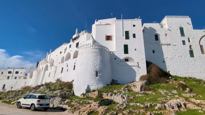
Bari, the anchor town you will keep coming back to

On almost every map with towns, Bari jumps out first.
It sits on the Adriatic coast, roughly halfway down the region. Big port. Major train station. Airport nearby. If you fly into Puglia, chances are you land here.
Bari feels busy. Real. Less polished. Old men playing cards. Laundry lines in Bari Vecchia. Scooters squeezing past you. It is not postcard-perfect, but it grounds you.
According to Italy’s national tourism board, Bari functions as “the principal transport and economic hub of Puglia.” That sounds dry, but it explains why every route seems to pass through it.
You might not fall in love with Bari immediately. That is okay. It grows on you.
North Puglia, often ignored, quietly important

Scroll north of Bari on the map and you hit Foggia and the Gargano area.
Foggia looks plain on a map. Flat land around it. Agricultural zones. Wheat fields. Many travelers skip it. Probably too fast.
But keep going northeast and the Gargano Peninsula appears. A bump sticking into the Adriatic. Towns like Vieste, Peschici, and Mattinata line the coast.
Cliffs. Forests. Unexpected curves in the shoreline.
Lonely Planet once described Gargano as “a region apart within a region,” and that fits. Even on a map, it feels slightly detached, like it is doing its own thing.
Central Puglia, where towns blur into one another
Zoom back down toward the center.
This is where Puglia starts to feel dense with names.
- Monopoli
- Polignano a Mare
- Conversano
- Putignano
- Alberobello
On a map, they sit close. Very close. You think, oh, that is easy. Ten minutes. Maybe fifteen.
Well, actually… roads twist. Traffic happens. You stop for coffee. Then a swim. Then lunch runs long.
Polignano a Mare, right on the Adriatic, is the one everyone recognizes. That beach wedged between cliffs shows up everywhere. The first time I saw it in person, I laughed a little. It looked unreal, like someone dropped turquoise paint into stone.
Alberobello sits inland, slightly south. Its trulli roofs look like tiny dots on satellite view. UNESCO officially lists it as a World Heritage Site, calling it “an exceptional survival of prehistoric building techniques.” On the ground, it just feels strange and charming and oddly normal at the same time.
The Valle d’Itria triangle
Maps often show a loose triangle in central Puglia. This is the Valle d’Itria.
The three towns you keep seeing:
- Alberobello
- Locorotondo
- Martina Franca
Locorotondo especially stands out. The name curls around itself. On the map, it looks compact. Circular. Hence the name.
Martina Franca sits a bit higher. Slightly cooler air. Baroque buildings. Wider streets.
This area is olive trees, dry stone walls, rolling hills. Less sea, more countryside. If you stay here, your map becomes your best friend. Roads intersect in confusing ways. You will second-guess yourself. Then probably pull over and ask someone.
South Puglia, where maps stretch out again

Scroll farther south and things spread out.
Brindisi appears on the Adriatic side. Another port town. Quieter than Bari. More open space. Historically important, though maps do not show that weight.
Then you reach Lecce, inland but close to the sea. Lecce glows. The stone color changes with the light. Morning is soft. Afternoon is blinding. Evening feels theatrical.
The New York Times once referred to Lecce as “the Florence of the South,” which people repeat endlessly. I am not sure I agree, but I get why they say it. The baroque density is intense.
South of Lecce, towns thin out again. You see Otranto on the Adriatic. Gallipoli on the Ionian. Two coastlines. Two moods.
Gallipoli’s old town sits on an island connected by a bridge. On a map, that detail looks minor. In person, it changes how the city feels entirely.
Seeing towns versus understanding distance
This is where travelers get tricked.
Maps with towns make Puglia look small. Manageable. A checklist.
It is not.
Here is a rough reality check.
Town to Town Drive Time
Bari to Polignano a Mare 40 minutes
Bari to Alberobello 1 hour
Alberobello to Lecce 1.5 hours
Lecce to Gallipoli 45 minutes
Bari to Vieste 2.5 to 3 hours
Distances feel longer in heat. Longer on narrow roads. Longer when you stop constantly.
Pro Tip:
When planning routes, group towns by area, not by how close they look on the map. Central Puglia one day. South another. North only if you commit to it.
Why Puglia towns developed this way
There is a reason towns sit where they do.
Historically, coastal towns faced invasion. Inland towns hid. Then trade returned, ports grew, and roads followed older paths. You still feel that logic when driving.
A regional planning study published by the University of Bari notes that Puglia’s town distribution reflects “centuries of defensive settlement patterns combined with agricultural land use.” In simpler terms, towns grew where survival made sense, not where tourists would later want them.
That explains the odd spacing.
What you miss if you only look at the map
Maps show dots. They do not show rhythm.
They do not show:
- How quiet Locorotondo feels at noon.
- How Bari Vecchia smells like bread at dawn.
- How Lecce empties for lunch.
- How coastal roads tempt you to stop every five minutes.
You might plan perfectly and still end up somewhere else. That is normal here.
Common planning mistakes
You might do one of these.
- Trying to see north, center, and south in three days.
- Booking one base without a car.
- Ignoring inland towns entirely.
Puglia asks you to choose. And then choose again once you arrive.
Final thoughts
Understanding Where Is Puglia Italy on a Map With Towns is less about memorizing names and more about accepting sprawl. This region stretches. It resists neat itineraries. Towns sit close, then far, then strangely close again.
Once you stop fighting that, the map becomes a suggestion, not a rule.
And honestly, that is when Puglia starts to make sense. Not on the screen. But somewhere between one town and the next, when you realize you stopped checking the map at all.
About the Creator
JamesMicheal
James is a co-author with one his friends at Travelistia. He loves to write adventure stories and explore adventure filled destinations. You can also submit your travel guest post by contacting us at [email protected]
Keep reading
More stories from JamesMicheal and writers in Wander and other communities.
Americans Are Traveling Like Never Before in 2025 — Here’s Why
Something’s happening out there. Airports are packed, highways are jammed, and “sold out” signs hang at hotels from Miami to Maui. Americans are traveling like never before, and not just for the usual reasons. It feels bigger, more emotional. There’s a hunger to move, to escape, to make up for lost time.
By JamesMicheal3 months ago in Wander
Elyse Bensusan Spotted Holding Hands With Venture Capitalist in NYC, Witness Claims
A source has shared additional details about an alleged public outing involving venture capitalist Michael and New York City psychologist Elyse Bensusan, adding to ongoing public interest surrounding their relationship.
By Alexanderaarya7 days ago in Wander


Comments
There are no comments for this story
Be the first to respond and start the conversation.