
Tour du Mont Blanc Itinerary:
A Hiker’s Dream Through France, Italy, & Switzerland


You’re thinking about hiking the Tour du Mont Blanc (TMB)? Smart move. This 105-mile (170 km) trek around Western Europe’s highest peak is the alpine adventure which I really think you will remember for a lifetime!
But here’s the thing: planning a TMB itinerary can feel overwhelming. Which route? How many days? Where to sleep? Don’t worry—I’ve got you. After scouring Reddit threads, TripAdvisor forums, travel planner by JetlyGo and my own dusty hiking boots, here’s your no-BS, actually useful guide to conquering the TMB.
Why the Tour du Mont Blanc?
Let’s start with the basics. The TMB loops through France, Italy, and Switzerland, offering jaw-dropping views of glaciers, wildflower meadows, and quaint villages. It’s challenging (think 32,800+ ft of elevation gain) but doable for most fit hikers. Unlike crowded U.S. trails, the TMB blends rugged wilderness with European charm—think espresso pit stops and cheese fondue refuels.

The Classic 10-Day Itinerary (With Upgrades!)
Most hikers finish the TMB in 7–11 days. I’m splitting the difference with a 10-day itinerary that balances mileage, highlights, and secret spots. Pro tip: Add rest days if you want to savor it!
Day 1: Les Houches (France) → Les Contamines
Distance: 10.5 miles | Elevation Gain: 2,200 ft
Start in Les Houches (near Chamonix) and hike through pine forests to Col de Voza. Skip the crowded Bellevue cable car route—opt for the Truc Trail for quieter meadows. End in Les Contamines, a cozy village with fresh croissants and hot showers.
Sleep: Refuge Nant Borrant (book ahead for their legendary tartiflette).
Day 2: Les Contamines → Les Chapieux

Distance: 11 miles | Elevation Gain: 4,300 ft
Today’s a beast, but the views from Col du Bonhomme are worth the sweat. Detour to Col des Fours (if weather permits) for a sneak peek of Mont Blanc’s icy face. Les Chapieux is a tiny hamlet—stock up on snacks at the lone bakery.
Sleep: Refuge des Mottets (rustic, but the sunset over the valley is magic).
Day 3: Les Chapieux (France) → Rifugio Elisabetta (Italy)
Distance: 11 miles | Elevation Gain: 3,600 ft
Cross into Italy via Col de la Seigne. The descent into Val Veny feels like entering a postcard. Rifugio Elisabetta sits under the Miage Glacier—ask for a window seat at dinner.
Secret Spot: Detour to Lac Combal for mirror-like reflections of Mont Blanc.
Day 4: Rifugio Elisabetta → Courmayeur
Distance: 11 miles | Elevation Gain: 2,000 ft
Hike through larch forests to Courmayeur, Italy’s answer to Chamonix. Soak your legs at QC Terme Spa (trust me). Explore cobblestone streets and carb-load on pasta at Ristorante Pierre Alexis 1877.
Sleep: Hotel Bouton d’Or (affordable + mountain views).
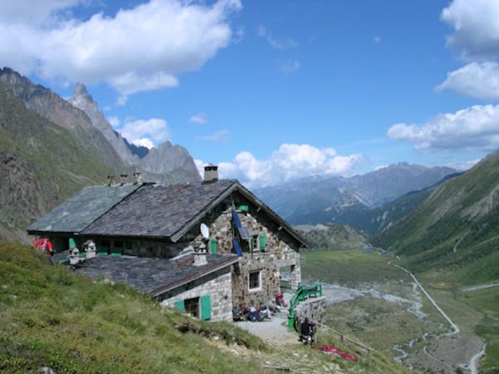
Day 5: Courmayeur → Rifugio Bonatti
Distance: 8 miles | Elevation Gain: 2,600 ft
This short day lets you savor the Val Ferret—arguably the TMB’s most stunning valley. Rifugio Bonatti is a hiker’s haven with dorm rooms facing the Grandes Jorasses.
Pro Tip: Arrive early to snag a spot on the terrace for golden hour.
Day 6: Rifugio Bonatti → La Fouly (Switzerland)

Distance: 12 miles | Elevation Gain: 2,900 ft
Cross into Switzerland via Grand Col Ferret. The descent into La Fouly is pure Swiss bliss—think wooden chalets and chocolate shops.
Sleep: Hotel Edelweiss (family-run, with hearty rosti dinners).
Day 7: La Fouly → Champex-Lac
Distance: 9 miles | Elevation Gain: 1,800 ft
A chill day! Follow the Drance River to Champex-Lac, a lakeside village. Rent a paddleboat or nap under pine trees.
Don’t Miss: Ice cream at Le Glacier (try the hazelnut).
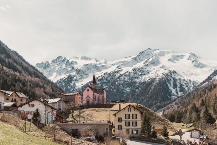
Day 8: Champex-Lac → Trient (Switzerland)
Distance: 10 miles | Elevation Gain: 2,600 ft
Two route options:
Bovine Route (easier, great for wildflowers).
Fenêtre d’Arpette (harder, with epic glacier views—check snow conditions!).
Trient’s pink church is iconic.
Sleep:
(ask for extra blankets—it gets chilly!).
Day 9: Trient → Tré-le-Champ (France)
Distance: 9 miles | Elevation Gain: 3,300 ft
Return to France via Col de Balme. The Aiguilles Rouges range steals the show here.
Secret Spot: Detour to Lac Blanc for a turquoise alpine lake (adds 2 hours—worth it!).
Day 10: Tré-le-Champ → Les Houches
Distance: 10 miles | Elevation Gain: 2,600 ft
Finish strong with the TMB’s toughest day. Navigate ladders and cliffs on the Grand Balcon Sud before descending to Les Houches. Celebrate with champagne at Le Vieux Campeur.
Hidden Gems & Pro Tips
Avoid Crowds: Start early (by 7 AM) and hike counterclockwise (most go clockwise).
Wild Camping: Legal in parts of Switzerland and France—ask locally.
Cheese Alert: Try Reblochon in France and Raclette in Switzerland.
Gear Up: Pack layers—weather shifts FAST. Waterproof boots are non-negotiable.
When to Go
July–September is prime. August is busy; September offers quieter trails and golden larch trees. Snow lingers on high passes until July—check conditions!
How to Book
Refuges: Book 6+ months ahead for popular spots (Bonatti, Elena). Use Autourdumontblanc.com.
Luggage Transfers: Companies like Ultimate TMB shuttle bags between hotels.
Guides vs. Solo: Guided groups cost $$$ but handle logistics. Solo? Grab the Cicerone Guidebook.
Final Thoughts
The TMB isn’t just a hike—it’s a rolling dinner party with mountains. You’ll partner with hikers from Sydney to Stockholm, eat your weight in cheese, and maybe even cry a little on those uphill slogs. But when you’re sipping wine in Courmayeur, watching the sun hit Mont Blanc’s summit, you’ll know: This is why we hike.
About the Creator
JetlyGo
JetlyGo is your go-to travel companion for creating personalized itineraries, discovering hidden spots, and planning trips on a budget. We’re passionate about turning every journey into a memorable adventure at JetlyGo.com


Comments
There are no comments for this story
Be the first to respond and start the conversation.