
The World’s Strangest Border: Where One Country Lives Inside Another
Exploring the fascinating and unusual border system between India and Bangladesh, once considered the most complex boundary on Earth.


Borders usually appear simple on maps—clear lines separating one nation from another. Yet in some places, the reality is far more complicated. For many years, the border between India and Bangladesh was considered one of the strangest and most confusing borders in the world. It contained dozens of tiny pieces of land belonging to one country but completely surrounded by the other, creating a geographical puzzle that fascinated historians, geographers, and travelers alike.
These unusual territories were called enclaves—small pockets of land belonging to one country but located inside another country’s territory. Along the India–Bangladesh border, there were once more than 160 such enclaves. Some were extremely small, while others had entire villages living inside them. In an even stranger twist, a few enclaves contained counter-enclaves, meaning a piece of one country inside another country, which itself was inside the first country. This layered geography made the region one of the most complicated borders ever recorded.
The most famous example was the enclave known as Dahala Khagrabari. It was considered the world’s only third-order enclave—a piece of India inside Bangladesh, which was inside India, which itself was surrounded by Bangladesh. In simple terms, it was like a tiny island of land trapped within multiple layers of different countries.
But how did such a strange border come into existence? The story goes back centuries to the time of regional kingdoms in South Asia. According to historical accounts, parts of the land were controlled by the rulers of Cooch Behar and the Mughal-controlled territory of Rangpur. Over time, pieces of land changed hands through battles, treaties, and political agreements. Instead of reorganizing the territory completely, rulers often kept small pockets of land under their control even if they were surrounded by the rival kingdom. When modern national borders were later drawn, these tiny fragments remained, turning into international enclaves.
The situation became even more complicated after the partition of the Indian subcontinent in 1947, which created the new state of Pakistan. At that time, Bangladesh was actually known as East Pakistan, and the enclaves suddenly became international territory surrounded by a different nation. When Bangladesh gained independence from Pakistan in 1971, the enclaves remained trapped in a confusing legal and political situation.
Life for people living inside these enclaves was extremely difficult. Many residents lacked basic government services such as schools, hospitals, electricity, and proper roads. Because their villages belonged to a different country than the land surrounding them, they often had trouble accessing police protection or administrative support. For decades, people lived almost stateless lives—citizens of a country that was physically difficult to reach.
In many cases, residents had to cross foreign territory just to visit a hospital or government office in their own country. Some villages had no official recognition for years, leaving residents without identification documents or legal rights. This unusual situation attracted global attention, and journalists frequently described the region as one of the most bizarre borders on Earth.
The issue was finally addressed in 2015 when India and Bangladesh signed a historic agreement known as the India–Bangladesh Land Boundary Agreement. Under this treaty, both countries agreed to exchange enclaves and simplify their border. India transferred some territories to Bangladesh, while Bangladesh transferred others to India. As a result, more than 50,000 people were given the option to choose their nationality and finally gain full citizenship rights.
The agreement brought a major change to the lives of residents. Roads, electricity, schools, and healthcare facilities slowly began reaching these once-isolated communities. What had long been a geographical curiosity and humanitarian problem finally found a practical solution through cooperation between the two nations.
Today, the former enclave region remains an important example in the study of political geography. It demonstrates how historical events, colonial boundaries, and political decisions can shape the lives of thousands of people in unexpected ways. While the strange border puzzle has largely been resolved, it still captures the imagination of those who study unusual places around the world.
In the end, the story of the India–Bangladesh enclaves reminds us that borders are not always simple lines on a map. Sometimes they are complex legacies of history—strange, fascinating, and deeply connected to the lives of the people who live along them.
About the Creator
Irshad Abbasi
Ali ibn Abi Talib (RA) said 📚
“Knowledge is better than wealth, because knowledge protects you, while you have to protect wealth.
Keep reading
More stories from Irshad Abbasi and writers in Wander and other communities.
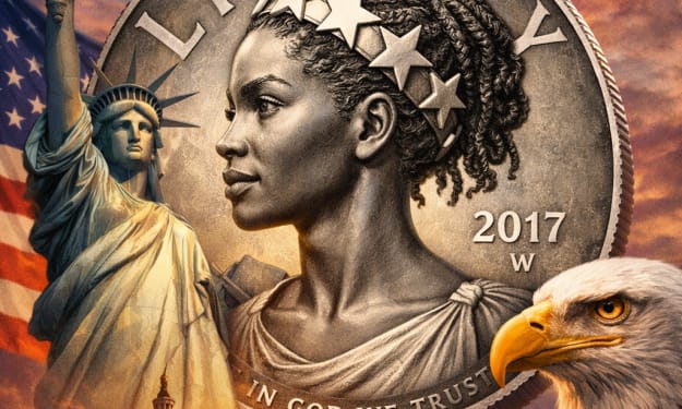
Black Liberty on a Commemorative Coin: Redefining America’s Symbol of Freedom
In recent years, the United States has taken symbolic steps to reflect the diversity of its people in national imagery. One of the most notable examples came when the U.S. Mint introduced a commemorative coin depicting Liberty as a Black woman. For more than two centuries, Liberty—the personification of freedom in American iconography—had traditionally been portrayed as a white woman of classical European appearance. The introduction of a Black Liberty marked a significant shift in how the nation represents its ideals.
By Irshad Abbasi about 16 hours ago in History
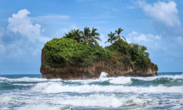
Worth the Wait: Puerto Viejo, Costa Rica
Beach bumming in a small Caribbean beach town sounded like a perfect way to end our 6-month trip through Mexico and Central America. Or so we thought. The foul, fishy stench of rotten seaweed hit our nostrils as we stepped from the cramped bus and looked out at a rather depressing, empty, and underwhelming black sand beach. It was pouring with rain, and we had to quickly fish out our ponchos. We thought, this couldn’t be it, could it?
By Sh*t Happens - Lost Girl Travel5 days ago in Wander


Comments
There are no comments for this story
Be the first to respond and start the conversation.