
Pacific enigma
Why Don’t Planes Fly Over the Pacific Ocean?

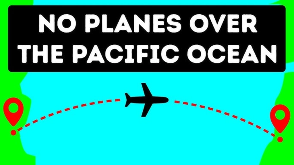
Have you ever wondered why your flight from the U.S. to Asia seems to take a detour over Alaska rather than heading straight across the Pacific Ocean? It’s a question that might seem puzzling at first, especially when it looks like a direct route would be much quicker. But as it turns out, the reasons behind these flight paths are a fascinating mix of safety, efficiency, and geography.
Safety Considerations
When you see a flight path that avoids crossing the vast expanse of the Pacific Ocean, safety is often a primary concern. The Pacific is not only the largest but also the deepest ocean on Earth, stretching over 63 million square miles. In the rare event that an aircraft encounters a significant problem, having a diversionary airport can be crucial. While the Pacific Ocean offers few options for emergency landings, regions like Alaska provide more frequent airport facilities. Although Alaska may not have a high density of international airports, it is still a preferable location compared to the middle of the ocean, where finding a suitable place to land could be nearly impossible. Pilots prefer routes that offer potential landing spots, even if emergencies are rare. This strategic planning minimizes risks and ensures that even if something goes wrong, there are viable options for a safe landing.
Fuel and Time Efficiency
Airlines, like any business, are driven by the need to optimize fuel efficiency and minimize operational costs. One of the most significant factors in planning flight routes is finding the most efficient path, which often involves choosing routes that appear less direct on a flat map but are actually shorter in the three-dimensional space of our planet. Flying directly across the Pacific Ocean might seem like the quickest route, but it isn’t always the most fuel-efficient. The shortest distance between two points on the Earth’s surface is along a great circle route, which can be quite different from the straight-line path depicted on a two-dimensional map. Great circle routes account for the Earth’s curvature and offer a more accurate representation of the shortest distance, leading to more efficient fuel consumption and quicker travel times.
Understanding Earth’s Curvature
To grasp why planes avoid crossing the Pacific Ocean directly, it’s essential to understand the Earth’s curvature. The Earth is a sphere, albeit slightly flattened at the poles and bulging at the equator, known as an oblate spheroid. This curvature affects flight paths significantly. On a flat, two-dimensional map, a flight path that looks longer might actually be shorter when considering the Earth’s three-dimensional shape. A great circle route, which represents the shortest distance between two points on a sphere, is not always a straight line on a flat map. For instance, placing a string from Los Angeles to Tokyo on a globe shows a curve, not a straight line. This curvature reflects the shortest path, which is more efficient than what might appear to be a direct line on a map.
The Earth’s Shape and Rotation
The Earth’s shape and rotation also play a role in determining flight routes. The planet is not a perfect sphere but an oblate spheroid, with a bulge around the equator. This equatorial bulge makes flights that head toward the poles shorter than those flying directly east or west. The Earth’s rotation contributes to this bulge. As the Earth spins on its axis, centrifugal forces cause the equatorial region to expand. This rotational effect increases the planet’s diameter at the equator compared to the poles. The difference might seem minor — only about 40 miles — but it has a significant impact on flight paths. The combination of the Earth’s curvature and its equatorial bulge means that flights traveling north or south are often more efficient than those attempting to traverse long distances east to west.
Jet Streams and Turbulence
Another critical factor influencing flight routes is the presence of jet streams. These high-altitude air currents, located near the top of the troposphere, can dramatically affect an aircraft’s speed and fuel consumption. Jet streams flow from west to east and can reach speeds of over 200 mph. Pilots use jet streams to their advantage, flying with them to save time and fuel. However, jet streams can also introduce turbulence, particularly clear-air turbulence, which occurs along the edges of these streams. This type of turbulence is challenging to predict and can be much more intense than typical turbulence. Therefore, flight routes are carefully planned to minimize the risk of encountering severe turbulence while still taking advantage of the beneficial effects of jet streams.
Flight Routes Over Open Water
Despite these considerations, flights do sometimes traverse the Pacific Ocean, particularly for routes to destinations like Australia or other remote locations. Flights over open water are often chosen to avoid land-based weather phenomena, such as thunderstorms, which can be more severe and challenging to navigate than open ocean conditions. Over water, the atmosphere tends to be smoother because there are fewer sources of turbulence compared to land, where uneven heating can cause significant air disturbances. Additionally, while flying over the ocean, pilots can avoid severe weather systems and turbulence that might be more prevalent over land.
Final Thoughts
In summary, the seemingly indirect flight paths across the Pacific Ocean are a result of careful planning that considers safety, fuel efficiency, and geographical factors. While it might look like a detour on a flat map, these routes are designed to maximize safety, minimize fuel consumption, and leverage natural air currents. Understanding the intricacies of flight planning helps explain why the routes we take are often more complex than they appear at first glance.
About the Creator
Horace Was
Essay Writer, Aviation and Technology Expert
Keep reading
More stories from Horace Was and writers in Wander and other communities.
The Iconic Blue Globe
The history of Pan-American World Airways, or Pan Am, is a captivating saga of innovation, luxury, and global connectivity. Founded in 1927, Pan Am was more than just an airline; it was a symbol of progress and sophistication that left an indelible mark on the world. Central to Pan Am’s identity was its iconic blue globe logo, a symbol that transcended mere branding to become a powerful cultural icon. This blog post explores the cultural impact of Pan Am and how its blue globe logo became emblematic of an era.
By Horace Wasabout a year ago in Wander
Are Trains in Morocco Kid-Friendly? by Morocco Family Vacation
Traveling with kids often means rethinking everything you take for granted as an adult from transport to meals to pacing. On our family trip to Morocco, one question kept coming up: Are trains in Morocco kid-friendly?
By Ariel Cohen5 days ago in Wander


Comments
There are no comments for this story
Be the first to respond and start the conversation.