
Map of when the solar eclipse reached totality across its path
Solar Eclipse 2024


The eclipse began in the U.S. as a partial eclipse beginning at 12:06 p.m. CDT near Eagle Pass, Texas, before progressing to totality by about 1:27 p.m. CDT and then moving along its path to the northeast over the following few hours.
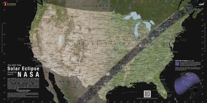
NASA shared times for several cities in the path of totality across the U.S. People could have also checked their ZIP code on NASA's map to see when the eclipse was to reach them if they were on, or near, the path of totality — or if they saw a partial eclipse instead.
How much of the eclipse did people see if they live outside the totality path?
While the April 8 eclipse covered a wide swath of the U.S., outside the path of totality observers may have spotted a partial eclipse, where the moon covers some, but not all, of the sun, according to NASA. The closer they were to the path of totality, the larger the portion of the sun that was hidden.
NASA allowed viewers to input a ZIP code and see how much of the sun was to be covered in their locations.
Could there be cloud cover be during the solar eclipse?
Some areas along the path of totality had a higher likelihood of cloud cover that could interfere with viewing the eclipse. Here is a map showing the historical trends in cloud cover this time of year.
About the Creator
Olaoluwa
Ola was born 24th May 2011
He is a Story teller, Reasearcher, Poem Writer and lot more


Comments
There are no comments for this story
Be the first to respond and start the conversation.