
Met Office Names 29 Areas Facing Snow on Wednesday – Full List
Residents urged to prepare for hazardous conditions and delayed commutes Cold front brings snow and ice to large parts of the UK Motorists and schools on alert as winter weather tightens grip Higher ground expected to see the heaviest snowfall Transport services brace for early morning chaos Councils deploy gritters ahead of overnight freeze Communities warned to check forecasts and avoid unnecessary travel Wintry showers set to affect England, Wales and Scotland

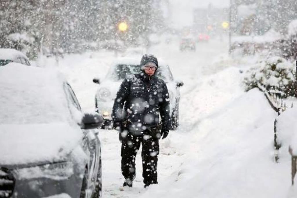
The Met Office has issued weather warnings for 29 areas across the United Kingdom as a fresh wave of cold air is set to bring snowfall, icy roads, and potential travel disruption on Wednesday. Forecasters say the developing weather system could create hazardous conditions, particularly during the morning commute, with snow expected to fall across parts of England, Wales, and Scotland.
Yellow weather warnings for snow and ice have been put in place after meteorologists observed a cold front moving in from the northwest, colliding with moist Atlantic air. This combination is forecast to trigger widespread wintry showers, with heavier snow likely over higher ground and in northern regions.
Snowfall Expected Overnight
According to the Met Office, rain will begin pushing into the affected regions late Tuesday evening before turning to snow as temperatures drop close to or below freezing. Accumulations of between 1 and 3 centimetres are likely in many areas, with up to 5 centimetres possible in elevated locations such as hills and moorlands.
“Snowfall will be variable, but some communities may wake up to wintry scenes and slippery conditions,” a Met Office spokesperson said. “There is also a risk of ice forming on untreated surfaces, which could make pavements and roads particularly dangerous.”
Forecasters added that temperatures are expected to remain low throughout Wednesday morning, meaning snow may not melt quickly and could continue to affect travel into the afternoon.
Full List of Areas Affected
The 29 areas identified by the Met Office include regions across northern England, Wales, and large parts of Scotland:
England:
Derbyshire, Durham, Cheshire East, Cumbria, Greater Manchester, Lancashire, Staffordshire, North Yorkshire, South Yorkshire, West Yorkshire.
Wales:
Conwy, Denbighshire, Flintshire, Gwynedd, Powys, Wrexham.
Scotland:
Angus, Clackmannanshire, Dundee, Fife, Perth and Kinross, Stirling, Aberdeen, Aberdeenshire, Moray, Highland, Argyll and Bute, Orkney Islands, Shetland Islands.
Residents in these areas have been advised to remain alert for changing conditions and to monitor local forecasts.
Travel Disruption Likely
Transport authorities have warned that roads may become slippery, especially on higher routes and rural roads. Motorists are being urged to allow extra time for journeys and to avoid unnecessary travel if conditions worsen.
Rail operators are also preparing for possible delays, particularly in Scotland and northern England, where snowfall and icy tracks could affect timetables. Airports in affected regions have advised passengers to check flight updates before setting off.
“Even light snowfall can cause major knock-on effects during peak travel hours,” said a transport official. “We are prepared, but passengers should plan ahead and expect delays.”
Bus services may also be disrupted in hillier areas, while school transport providers are monitoring the situation closely.
Schools and Local Authorities on Alert
Several local councils have confirmed that gritters and snowploughs will be deployed overnight to treat main routes. Schools have been asked to prepare contingency plans, including delayed openings or temporary closures if conditions deteriorate.
Parents are being advised to check school websites and local authority announcements early on Wednesday morning.
Community groups have also been reminded to check on vulnerable residents, particularly elderly people and those living alone who may struggle in freezing temperatures.
Risk of Ice and Power Outages
In addition to snowfall, forecasters have warned about the possibility of freezing rain and icy patches forming as temperatures fluctuate around zero. This raises the risk of slips and falls, as well as traffic accidents.
Utility companies are on standby in case of power outages caused by falling branches or damaged lines, especially in areas where wet snow may accumulate on trees and cables.
Households are being encouraged to charge devices in advance, keep torches and batteries available, and ensure they have enough heating supplies to last through the cold spell.
Why This Weather Is Happening
Meteorologists say the current conditions are being driven by a shift in atmospheric pressure patterns, allowing cold Arctic air to move southwards into the UK. This cold air is interacting with milder, moisture-rich systems from the Atlantic, creating ideal conditions for snow.
“This is a classic winter setup,” explained one weather analyst. “It’s not unusual, but the timing and spread mean many people will feel its impact at once.”
The cold snap is expected to continue for several days, with night-time temperatures remaining below freezing in many of the affected areas.
Safety Advice
The Met Office and emergency services have issued clear guidance for residents in warning zones:
Avoid unnecessary travel during heavy snowfall.
Wear appropriate footwear to reduce the risk of slipping.
Drive slowly and keep emergency supplies in vehicles.
Stay informed through official weather updates.
Check on neighbours who may need assistance.
Officials stress that yellow warnings do not mean severe weather is guaranteed, but they highlight an increased risk of disruption and injury.
Looking Ahead
Conditions are forecast to gradually improve later on Wednesday from the south, though further wintry showers may continue in Scotland and northern England into Thursday. Additional warnings could be issued if snowfall totals increase or if ice becomes more widespread.
For now, authorities are urging calm preparation rather than panic. With the correct precautions, much of the disruption can be minimized.
As the UK braces for another burst of winter weather, the message from forecasters is clear: stay informed, stay cautious, and be prepared for snow-covered roads and cold conditions as Wednesday begins.
About the Creator
Fiaz Ahmed
I am Fiaz Ahmed. I am a passionate writer. I love covering trending topics and breaking news. With a sharp eye for what’s happening around the world, and crafts timely and engaging stories that keep readers informed and updated.
Keep reading
More stories from Fiaz Ahmed and writers in Longevity and other communities.
Greenland Declares State of Emergency as Scientists Link Growing Presence of Orcas to Accelerating Ice Melt
The government of Greenland has declared a state of emergency in response to an alarming environmental shift in its Arctic waters — a surge in the presence of orcas in areas once locked in sea ice, which scientists say underscores how rapidly the region’s ice is melting and reshaping the ecosystem. The movement of these apex predators into newly open fjords and coastal zones has become both a symbol and a scientific indicator of climate change’s far-reaching impacts. Faculty.world The emergency declaration, announced by local authorities in Nuuk and surrounding coastal regions, is the first of its kind tied to ecological change rather than a single weather event or industrial accident. Officials said the decision reflects concern about cascading effects on wildlife, indigenous subsistence practices, infrastructure safety, and community livelihoods as the Arctic’s age-old balance unravels. Orcas in Greenland: An Unexpected Sign of Change Traditionally, orcas — also known as killer whales — were rare visitors to Greenland’s inner fjords and coastal waters. Thick, multi-year sea ice once blocked open pathways deep into the Arctic, preventing these large marine predators from accessing hunting grounds dominated by seals, narwhals and other endemic species. Faculty.world But satellite data and local observations over the past decade show a stark decline in summer sea-ice extent, with warm ocean water opening up channels that were once permanently frozen. Where ice used to stretch uninterrupted across Greenland’s western fjords into the shoulder months of summer, researchers now see expanses of open water that orcas exploit. Faculty.world Scientists describe these shifts in terms of “climate fingerprints” — specific biological and ecological signals that reflect broader environmental change. Orcas are now becoming one of the clearest indicators of warming seas and retreating ice in the Arctic, researchers say. Faculty.world From Rare Sightings to Regular Visitors In fishing villages along Greenland’s fjords, elders and hunters speak of dramatic changes. A decade ago, spotting a killer whale near shore was an unusual event; now, pods of 20 or more orcas are seen regularly, patrolling open channels formerly clogged with ice. Residents describe pods chasing seals and narwhals, forcing traditional prey into shallower waters where they are more vulnerable. Faculty.world Local councils have begun to receive more reports of orca encounters near settlements and traditional hunting grounds. The presence of orcas is reshaping the behavior of seals and narwhals, altering food availability and hunting success for Inuit and other communities who rely on these species for subsistence and cultural traditions. Faculty.world Officials say the emerging patterns are too consistent and too widespread to ignore. “When the predators show up, it’s a signal that the environment they once kept at bay has fundamentally changed,” one Greenlandic marine ecologist said. “It’s not just about whales — it’s about the whole system being in motion.” Faculty.world Why Orcas Matter to Ice Melt Scientists are careful to clarify that orcas themselves do not cause ice melt. The primary driver remains warming air and ocean temperatures, fueled by human-induced greenhouse gas emissions. The real concern is how the effects of climate change are now feeding into ecological feedback loops that accelerate ice loss. Caberfeidh Bar Orcas, being large and mobile, follow open water. Their movements into former ice-covered areas are symptomatic of warmer seas and rapidly retreating ice. When sea ice thins or breaks into smaller plates, it absorbs more sunlight and melts faster; the open water left behind warms up and further weakens ice edges. Each summer’s melt makes it easier for open water to persist longer into seasons that historically refroze. Faculty.world Marine researchers are also examining how orca activity can amplify local mixing in the water column. As orcas move and hunt in shallow fjords, they churn water that would once have been smothered in ice, interacting with warmer ocean currents and subtly increasing erosion of ice fronts from below. Faculty.world Impact on Communities and Culture For Greenland’s coastal residents, the changes are both ecological and cultural. Hunters who once relied on stable seasonal ice are now navigating unpredictable conditions, with sea ice breaking earlier in the year and forming later. Harsh new realities mean shifts from sleds to small boats and new safety practices to avoid thin ice and open channels where orcas and strong currents converge. Faculty.world Inuit traditions and knowledge — passed down through generations — are being tested as the climate rewrites the rhythms of ice and animal migrations. Elders warn younger generations that the calendar of ice, once reliable for travel and hunting, now fails to match what’s visible outside their front doors. Faculty.world A Broader Climate Message Greenland’s state of emergency is intended to send a clear message: the Arctic’s transformation is not a distant future but a present reality with consequences on ecosystems and human lives. Scientists overseeing climate models say that dramatic ice melting — whether captured by satellite data or measured in growing orca sightings — reflects shifts that will continue unless greenhouse gas emissions are sharply reduced worldwide. Caberfeidh Bar The declaration is both a call for global action and a recognition of local urgency. Greenland’s communities are already adapting, but researchers say the pace of change demands broader international engagement on climate policy and support for Arctic resilience. Conclusion What once seemed like an extraordinary sight — killer whales in the high Arctic — is now a daily reality and a stark indicator of climate change’s reach. Greenland’s emergency declaration does not downplay the seriousness of the crisis; it acknowledges that ecological change is already reshaping food webs, cultural practices, and physical landscapes. The orcas in Greenland’s fjords are not villains, but they are unmistakable markers of a world where ice is no longer the constant it once was. As Greenland navigates the immediate response and the long road ahead, its experience resonates far beyond the Arctic. This state of emergency is a signal flare — one that scientists and communities hope will spur collective action before other ecosystems face similar tipping points.
By Fiaz Ahmed a day ago in Longevity
Day 4 of Quitting
If this is how sobriety feels, maybe it’s better to go through life a little buzzed… this, along with other hits like, I want to kill myself, I wish I was dead, and I’m going to throw myself off a bridge have been the only thoughts on rotation these past few days. I promise myself that if, in a month, I still feel like this (‘this’ meaning despondent, full of rage, and simultaneously numb) I can go back to smoking. Until mid-February though? Nicotine is off the table.
By sleepy drafts29 days ago in Longevity
Writing About Writing: The Rainbow Trap
The good thing about living in modern times is that LGBTQ representation in media is increasing. Not just in niche and Independant media, either, but also in mainstream media. Books, movies, TV shows, comics... they're finally catching on that LGBTQ+ people form a significant part of their audience, and deserve to see themselves on screen and in fiction, not just as victims in documentaries and true crime shows.
By Natasja Rosea day ago in Writers


Comments
There are no comments for this story
Be the first to respond and start the conversation.