
South Asian Geo-Political Shifts: Past and Present
Introduction, History & Present Situation

I
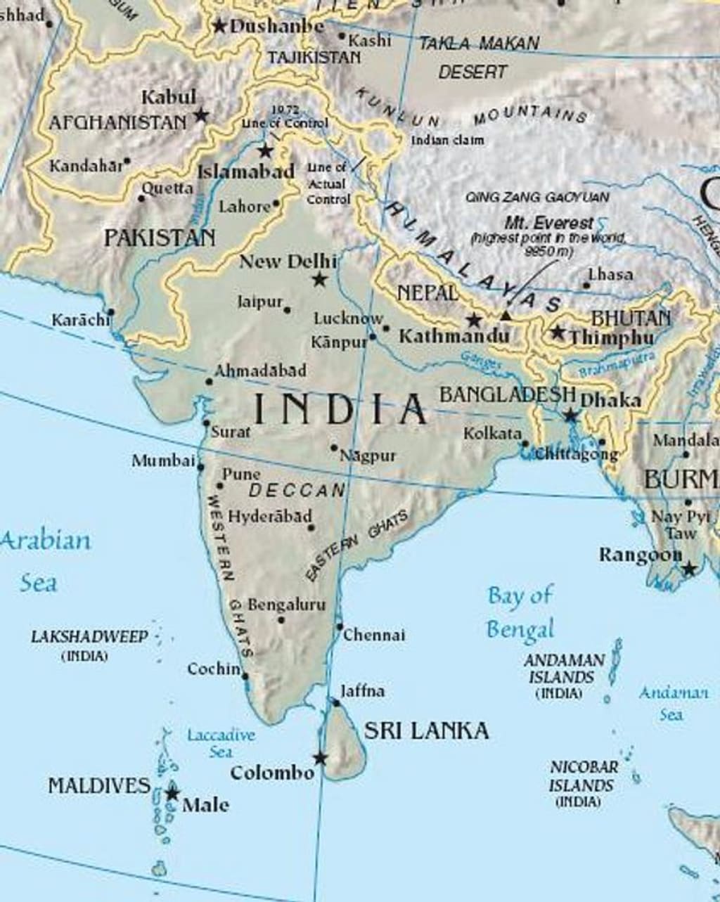
NBefore discussing the geo-political issues, for this paper, the South Asian (SA) concept needs to be clarified. Countries contiguous to the Indian Sub-continent and within the definition of ‘Indian Sub-Continent’ have been discussed. But countries of the Sub-Continent, mainly in the region between the Indian Ocean and the Bay of Bengal are within the realm of South
Asian geopolitics. Therefore, two of the Island nations of South Asia, Maldives, and Sri
Lanka, are connected with the geopolitics of SA and have also been brought into the
framework as nations of IOR (Indian Ocean Region)
.
Geographic Features of the Sub-Continent/South Asia
The geographical features of the subcontinent as a whole are unique and occupy a dominating
place in global geopolitics. The geographical setup of the Indian Subcontinent is open from two
sides, west and east. But the north is bounded by one of the highest and the longest mountain
ranges of the Himalayas which makes it nearly impossible to cross except through limited
prominent passes. The most historical and famous pass within the range is the Khaybar Pass and
in the mid-west around Baluchistan is the Bolan Pass. Both passes connect the Sub-continent with
Central Asia through Afghanistan and Iran. It was the Aryans who are believed to first arrive at
the Sub-continent through these western passes in 1500 BCE. However, the first massive invasion
by foreign troops was through the Khyber Pass of Alexander the Great of Macedon in 326 BCE.
Since then, invasions in Central Asia appeared through these passes which instrumented the
establishment of the rules of various dynasties. Across the Northern Himalayas is a tract of Tibet
(now part of China) and North West is Xinjiang China.
Indian Sub-Continent has a huge land mass of around 4,440,000 sq km with a population of 1.8
billion. The land mass is bestowed by Indo-Gangetic plains17 with major river systems from the
West to the East. These river systems nourish from the Himalayan Glaciers and make the entire
Gangetic–Indus plains along with the plains around other river systems fertile and remain
cultivable throughout the years.
The trace of the first settlement and civilization still exists in the Indus valley of Mohenjo-Daro
and Harappa (Harappan/Indus Civilization18) proving the geopolitical importance of those ancient
times.
The South of the Sub-continent is bordered by one of the largest oceans of the world, the Indian
Ocean with an area of 70,560,00 square kilometers. The important strategic seas and the Bay of
the Ocean are, in the north and southeast, the Bay of Bengal, and the Andaman Sea respectively,
and in the west is the Arabian Sea, and in the southwest is the Laccadive Sea. Adjacent to the Sub-
continent is one of the most strategic and resourceful regions bordering the Sub-Continent is the
Persian Gulf which carries the bulk of the energy of the modern world to the east and the west
through the choke points of the Indian Ocean. Some of these choke points made the most contested
geopolitical real states since the opening of the Suez Canal in 1869, thus Bab El Mandap became
the hottest Choke point in the West. Other chokes like the Mozambique Channel, the Strait of
Hormuz, the Sunda Strait, and the Lombok Strait have been geopolitically important in the control of the Indian Ocean.
By the 19th century, the geopolitics of the Indian Subcontinent was fully exploited by the British
colonial rulers. By then, the Suez Canal shortened the distances from Europe to the Indian Sub-
continent. It was easier for the British sea power to control all the choke points that formed a string
of pearl around the Indian Sub-Continent. The newly opened Suez Canal served to further
accelerate the pace of communication into and out of the Indian Ocean. The British built major
naval bases at Simonstown at the Cape of Trincomalee in Ceylon which expanded to become vital
nodal points of power in the late 19th and early 20th centuries (Kearney, 2004).
The British were dominating their colonies from east to west and controlled almost all choc points
to guard the Indian Ocean. As Amitav Chowdhury puts it, “Between the early exploratory
adventures of the late 16th and 20th century, the British in the Indian Ocean were a consistent
presence. In this period, much of the competition for global commercial hegemony, territorial
expansion, and the control of strategic vantages were played out in the ocean’s arena.” (. As on 01
June 2023)
By the beginning of the twentieth century, the British Royal Navy with the help of the Bombay
marines had defeated most of their French and Dutch rivals from the rim of the bay. The Suez
helped the Royal Navy to establish full mastery. On the other hand, they had controlled all the
atolls and Islands in the Indian Ocean, developed all facilities for agriculture, took the manpower
from India up to the Malayan Peninsula and Hongkong, and controlled the Malacca Strait. On the
east of India, the entire Burma was brought under British rule controlling all the ports. With the
un rivalled control of the Indian Ocean, the British remained the superpower controlling vast
tracts of the Middle, South, and East Asia until WWI when the USA started to emerge as a
superpower.
It was WWII when Britain became economically weak and the colonies started achieving their
freedom. The religious division of Hindu Muslims resulted in riots for a separate Muslim religion-
based country. The British India was divided in 1947. The rest of the Colonies within the northern
rim of the Indian Ocean got their independence from the colonial rule after India and Pakistan
came into existence like Ceylon (now Sri Lanka) in 1948, Burma (now Myanmar) in 1948, and
Maldives much later in 1965.
With the withdrawal of the British from most parts of the Indian Ocean and its rim, less Diego
Garcia, a total of 38 independent countries became IOR (Indian Ocean Littoral) by the 1960s,
among which was India and situated both on the shore of Arabian Sea and the Bay of Bengal, till
1971. India however, had geo-strategic ascendency over other littorals with strategically located
Andaman Nicobar Island in the eastern southeastern Bay of Bengal.
Re-shaping Indian Sub-Continent: Post-1947
The independence of the Indian Sub-continent resulted in the division into two countries with a
huge alteration in the geography. With the loss of Baluchistan and the North West Frontier
Province (NWFP), independent India was deprived of direct overland access to the Middle East
and Central Asia. No more than that, British India’s geopolitical readiness as Halford Mackinder
once mentioned in his geopolitical perception of the British Empire laying importance on the North
West Frontier19(Menon, 2021, p. 12) and the geopolitical perception of the ‘Great Game’20 if not
dead, carried no more geopolitical importance for India.
India and Pakistan on the West shared a 3,310 km border which includes the Line of Control (LOC)
in disputed Kashmir21
. The North boundary remained unchanged as India shares 3,488 km of
borders which includes 890 km of the ‘disputed McMahon line’22. This was agreed upon between
British India and Tibet at Shimla in 1914 but the dispute remains to date terming the line drawn
‘arbitrarily’ by the British Raj. On the other hand, China and India share borders with Nepal and
with Bhutan who maintained their freedom to a great extent during the British Raj in India.
On the East, the Indian border with East Pakistan (now Bangladesh) stands at 4,096 km. The part
became a wedge between India and the Indian North Eastern part only to be linked by the Indian
narrow corridor of the ‘Siliguri Corridor’23 which made it difficult for the rest of India to be
integrated with the North East with a hostile Pakistani part.
Independence of India and Pakistan
As WWII came to an end, the world was getting divided between two victorious powers, the USA
and the USSR (United Soviet Socialist Republic) in Europe. Britain disappeared from the horizon
of superpower and the Indian Sub-Continent was divided into two independent states.
The geopolitical and geostrategic orientation of these two newly independent countries made a
drastic change soon after a year when Pakistan wanted to settle the most strategic piece of land,
Kashmir, with force. Both countries fought the first war over the Kashmir dispute a few weeks after independence in 1947 which ended under a truce brokered by the UN. As a result, Pakistan
gained one-third land of Jammu and Kashmir named Azad Kashmir, Gilgit Agency, and Baltistan.
On the other hand, India got two-thirds of Jammu and Kashmir with the rest of the Ladakh district
bordering China yet remaining disputed over the boundary line.
Be it as it may, the alteration and possession of part of Kashmir, Gilgit-Baltistan makes the border
dispute more complicated. As Joshi puts it, the border dispute between China and India, is ‘always
going to be a source of tension, and it certainly became one, since the Chinese do not agree to the
length of the border they claimed to be around 2000 km, the boundary for the area was always
going to be a source of tension, and it certainly became one, once other geopolitical interests
intruded’ (Joshi, 2022, p.3). The discrepancy ‘arises because the Chinese do not include the border
with Pakistan and then, their straight-line border in the foothills of Arunachal Pradesh (old NEFA:
North East Frontier Agencies24) helps make for the figure (Joshi; 2022; p45) (Chinese Claim).
For independent India, it was difficult to come out of the shoes of the British Raj. But it was India’s
first prime minister Pandit Jawahar Lal Nehru who decided to go against his colleagues like K.M.
Panikkar, C, Rajagopalachari, T.T. Krishnamachari, and others. They were keen to see India
maintaining close ties with England in India’s geopolitical sphere. Their idea, much before India’s
independence, was that India took a pivotal role in Asian countries to start with keeping England
tied (Menon, 2021, p. 44). These strategic and geopolitical thinkers of India also saw a big role of
India dominating the Indian Ocean, particularly K.M. Panikkar echoeing Mahan with of course
the British Indian Navy (ibid, p.45) in mind. Panikkar did not stop there but wrote and advised
Nehru, “The Indian Ocean area together with Afghanistan, Sinkiang, and Tibet as outer northern
ring constitute the real security of India. Geographically also this is one strategic unit, with India
as its great air-land center and the base and arsenal of naval power. From the central triangle of
India, the whole area can be controlled and defended” (Panikkar, 1946, pp. 85-90 as quoted by
Menon).
Mr. Nehru was also forced and persuaded by others to form Indian defense and foreign policy
(ibid), much that is currently apparent. V.D. Savarkar who espoused Hindutva even pleaded with
the British Raj to keep the armed forces under British command by recruiting Hindu youth (The
Wire, 2022). But Nehru wanted an independent role for India, championing those Asian countries
that were yet to achieve independence and where the Indian-origin troops were present till then.
Nehru saw ‘India’s Independence as the rise of Asia’. He decided to maintain ‘strategic
sovereignty’ and keep India away from two superpowers, and to a great extent, he succeeded. The
idea that Mr. Nehru got, much before the ‘independence’ was from the ‘The Asian Relations
Conference’ in New Delhi held in March- April 1947, a few months before India declared
independence organized by the Asian Council of World Affair25. The conference, with the idea of gathering newly independent Afro-Asian countries together in the Indonesian city of Bandung in
1955, was Nehru’s idea who was a key organizer along with Mr. Sukarno, the president of the
newly independent Indonesia, and a few other countries including Pakistan. The Delhi conference
also gave birth to the Non-Aligned Movement (NAM) in the 1950s in the aftermath of the Korean
War. Ultimately NAM was given shape in the Cairo conference in 1961. It was a great achievement
for India's geopolitical policy makers headed by Nehru.
India as its diplomacy in Asia first participated as peacekeepers in Korea in 1950 and Suez in
195626. Under British auspices, Indian-origin persons were settled all over the countries under
British colonial rule. India also raised its voice for their independence.
Sino-India-
27 Relations: 1959 - 1962. After the first Indo-Pak war in 1947-48, the bigger strategic
concern that upset the entire geopolitics of India was when China took control of Tibet in 1950.
By 1959, China was breathing on the Indian neck, bringing the Chinese boundary along a big
Indian track (Menon, 2021, p. 56). It was not only a setback for Indian foreign policy orientation
but a second geopolitical shift after the creation of Pakistan in India’s western and eastern flanks
as Olaf Caroe observed (Brobst, 2005, pp. 145-46). Nevertheless, after years of turmoil where
allegedly CIA-trained Tibetan guerrillas, with India’s covert knowledge28, and with the base
Provided by Nepal alongside the Tibet border, Mustang29 and in collusion with the then Pakistan
authority (in the then East Pakistan), involved in fomenting guerrilla resistance.
As for the involvement of the Government of Pakistan is an interesting episode in this fray with
India since both the countries had, by then, divergent geostrategic and political perspectives around
the Kashmir dispute. In this regard Riedel (2015), an ex-CIA officer, mentions in his book, "The
ISI arranged for them to stay briefly at an abandoned World War 2 airbase named Kurmitola
(Dhaka) .... the base was relatively primitive with a landing strip of 1,000 meters (sic) long,". He
further writes, "By October 1957, the first team of Tibetans was ready to go home and use their
newly developed skills to help the rebellion. Polish anti-communist emigres flew the B-17 bomber
and dropped the trained fighters in Tibet overflying Indian territory from Kurmitola again so that
no American would risk capture if anything went wrong...the mission was a success and the second
flight from East Pakistan followed in Nov 1957."30 Interesting to note both India and Pakistan were
colluding with the USA to stop the spread of Communism in the rest of Asia, but till the Chinese
occupation of Tibet, India was the closest friend of China and Mr. Nehru and Chinese Premier
Zhou Enlai were towering leaders of Afro-Asian countries and were regarded as the best of the friends. In India, both countries, India and China were known as Bhai-Bhai (brothers) with the
slogan ‘Hindi Chini Bhai-Bhai’(Rachenko,2014).31
Therefore, communism was perceived as a common threat to all these three countries, India,
Pakistan, and Nepal, that willingly got into the fight against communism which spread in Asia, in
particular. India stood clearly against the earlier stand of the ‘Hindi-Chini Bhai Bhai’ concept of
cooperation in the Asian region.
Tough India-Pakistan relation exacerbated soon after the partition on the dispute of Kashmir, but
on the hind side, Pakistan not only gained strategically important territory but also put a handicap
for India to maneuver easily on the west. In 1948, the Kashmir ceasefire brokered by the West and
implemented by the United Nations (UN) provided Pakistan a close link with the West, particularly
with the UK and the USA. In this regard, Dasgupta as quoted by Menon (2021) showed how power
politics was played by the UK and USA for a solution that went in favor of Pakistan. This favored
and put Pakistan willingly into the lap of the West. Though Pakistan had been at the Bandung
conference as one pioneer country and later a member of NAM, but did not maintain a ‘strategic
sovereignty’ like India. It allowed the USA to establish a base in Northern Pakistan to spy over
both China and mainly Russia32. But the fact remains that Pakistan’s geopolitics was and still is
around its big neighbor. Pakistan went pro-west and anti–communist even after General (later
Field Marshall) Ayub Khan took over the reign of Pakistan deposing the civilian government in a
military coup in 1958. That was the first-ever military takeover of a South Asian country. The
USA established a military relationship with Pakistan in the 1950s which continued till the 1965
Indo-Pak war.
Pakistan joined the Baghdad Pact in 1955 which later was known as the Central Treaty
Organisation (CENTO)33 as Pakistan had another part in the East as East Pakistan, almost
separating Indian North East from mainland India, and also justifiably joined the South Asia Treaty
Organisation (SEATO)34. This was another military pact aimed at providing Southeast Asia with
Collective Defence, almost concurrently that of CENTO. Thus, Pakistan was bound by these
alliances and could never maintain ‘Strategic Sovereignty’. Both these organizations were anti-
communist and were designed to stop the spread of communism almost at the beginning of the
Cold War as well as the spread of communist ideology, particularly in South Eastern Asia.
Pakistan remained a bulwark of the West against the spread of communism in South Asia.
Pakistan’s western-oriented geopolitics kept both the Soviet Union and China at bay though
Pakistan had an inaccessible yet disputed border with China during pre–Karakoram Highway days (KKH). China, however, never recognized Pakistan’s hold on Hunza and Gilgit in the North.
Therefore, China and the threat of communism remained a common factor for the newly
independent Sub-continent.
In 1949, Indian PM Mr. Nehru offered a ‘No war pact’ in a letter to the then Pakistani Prime
Minister Mr. Liaquat Ali Khan which remained inconclusive till 1950 (Ranjan, 1964, p.79). Even
in 1959, a month after Dalai Lama fled to India, he once again offered no-war pact and Pakistan
had not responded, as Mr. J.N.. Dixit (2002) wrote in his book, India-Pakistan in War and Peace’,
but Pakistan, then led by Ayub Khan, did not agree rather continued to assist the US to operate U2
spy planes from both wings against the Soviet Union and China.
The then CIA (Central Intelligence Agency), was continuing with clandestine operations against
China in Tibet, and the US U-2 spy missions continued regularly for spying over China. At the
same time, USA-trained Tibetan dissidents were regularly inducted from East Pakistan using the
vintage WWII Kurmitola airfield. Later Mustang, a remote mountain valley in Nepal, became the
anti-Chinese training base of Tibetan dissidents (Knaus, 1999; Conboy and Morrison, 2002,
Riedel, 2015). Though Pakistan and India did not have any pact as such but took some times active
and mostly passive parts in CIA operations until 1969 (Conboy and Morrison, 2002, p. 38)35. At
the height of the PLA (Peoples Liberation Army) operation in Tibet, the Chinese authority detected
the clandestine operation. The Chinese perceived Indian involvement and tacit approval of such a
clandestine operation.
Despite, the fact that India under Mr. Nehru had better relations with the Kennedy administration,
India became inclined to the USSR36 for military equipment. The USA tried to persuade Mr. Nehru
but the Western offer did not match the price. The Soviet Union gave India 12 MIG 21s free as a
friendly gesture. On August 17, 1962, a few months prior to Sino-Indian war, the Indo-Soviet
treaty37 was signed mainly for procuring defense equipment. Nehru was trying to counter the
USA’s supply of F-104 Star Fighter to Pakistan (Riedel, 2015, p.116). China was not happy that
the Soviet Union supplied hi-tech aircraft to a country that was not considered a friendly one to
them, particularly for interfering in Tibet. (op. cit, p. 99). These were viewed by the Chinese
violation of established relations through Panchsheel and ‘Hindi-Chini Bhai-Bhai’ (India- China
Brothers) pact in 1954. These events led to a fast deterioration of the relationship between the two
Asian giants. The bitterness over Tibet, Dalai Lama, and dispute over the borders, both in India’s
north in Ladakh and North East in NEFA (North East Frontier Agencies)38 made worse enemies
of countries that once held similar views of anti-imperialism.
1962 Sino
-Indian War and Beyond that Changed the Geopolitics of the Sub-Continent
Prelude
The main causes for the deterioration of relations between two giant neighbours, India and China,
seemed to be (1) interference in Tibet by India. Like British India, Nehru considered Tibet a buffer
within the communist menace of China. In all analysis, Nehru seemed to have stepped into British
shoes of India even after 1947.
(2) The exodus of Dalai Lama to India and shelter given first at the disputed (As China claims)
largest Buddhist monastery of Tawang (NEFA: now a district of Arunachal) and then to
Dharamshala which brought huge international attention to Buddhist persecution by the
communist China.
(3) Border dispute which remains complicated, especially in Ladakh, Aksi-Chin area to the south
of Karakoram Range. The area was inaccessible and India had neither an updated map nor many
ideas of this high-altitude plateau unless China produced a map in which a road connection
between Tibet and Xinjiang through a military road was shown on the Chinese map as China did
not recognize ‘Jhonson Line’40 much to the North East Aksai-Chin. China rather accepted the
‘Macartney-Macdonald Line’41. India objected to the Chinese unilateral move but China claimed
that the area was shown on the map which was produced by the Nationalist government. This
position of China in Aksai Chin and the road built thereafter was not acceptable to Nehru and he
termed his stand as firm ‘not open to discussion with anybody’ (“Sino-Indian border dispute”,
n.d.).
Nehru was under further pressure as China also refused to accept the ‘McMohan Line’42 on the
North Eastern border up to Burma (now Myanmar). In 1954, the Chinese map showed Bhutan,
Nepal, Sikkim, and NEFA (now Arunachal) as part of China (Menon, 2021, p. 89). Chairman Mao
Zedong claimed these four areas including Ladakh are the five fingers of Tibet (“Five Fingers of
Tibet”, n,d.). China still maintains that stand whereas she is dealing with both Bhutan and Nepal
as sovereign countries43
.
(4) Last but not the least, the earlier China offered to settle the border dispute amicably earlier by
trading Aksai Chin against China recognizing the McMahon Line. The Indian government of Mr.
Nehru ruled out such compromise, rather quietly implemented a forward policy
through war.
(5) Forward Policy44 of Nehru. The policy was based on setting up military posts behind Chinese
lines, in disputed territory, to gather intelligence and compel China with a show of force. The
Indian troops were of no match in terms of armed forces equipped with insufficient appropriate
weapons, equipment for snowline warfare, and unclear orders (Riedel, 2015, pp. 99-100; Noorani,
1970, pp. 136-141; Jensen, 2012, pp. 55-70).
All these and other geopolitical factors became the primary reason for the 1962 Sino – Indian war
that changed the geopolitics of the region in particular and Asia in general. On November 20, 1962,
the Chinese declared a unilateral ceasefire. Researchers like Nevil Maxwell45 and Prem Shanker
Jha46 opine that it was the disastrous forward policy of Mr. Nehru that gave reasons to counter-
attack India.
In that short war, India lost with a humiliating defeat. Having learned a lesson, India could not
maintain regular surveillance of Chinese moves from November 1962 and created the Tibet
refugee-based Special Frontier Force (SFF)47 (Shukla, 2020) which is enlarged at present and used
to monitor behind the Line of Actual Control (LAC)48
.
The effect of the 1962 war and its disastrous consequences became the psyche for the Indian nation
and policymakers. The geopolitics of, not only India but also South Asia, Asia, and the world have
since been shifting as a result of the Sino-Indian War of 1962.
Two major events factored in changes in policies affecting South Asia to an extent, the
assassination of Kennedy in November 1963 and followed by the death of Nehru on May 27, 1964.
After Kennedy, India drifted away from the USA’s strategic partnership to counter China as the
Johnson administration was busy with internal consolidation (Paul, 2013, p. 280-84) but the Nehru
government was still dependent on US military support against China. The other event that
polarized South Asia was the Indo-Pak War in 1965.
About the Creator
Riham Rahman
Writer, History analyzer, South Asian geo-politics analyst, Bengali culture researcher
Aspiring writer and student with a deep curiosity for history, science, and South Asian geopolitics and Bengali culture.
Asp
Keep reading
More stories from Riham Rahman and writers in Journal and other communities.
The Dark Knight Trilogy: A Tireless Guardian of the Shadows
Under the banner of Warner Bros., Christopher Nolan breathed new life into the Dark Knight through his groundbreaking trilogy. Departing from the predictable molds of comic book storytelling, Nolan offered a gritty, reimagined legend that redefined the superhero genre. This wasn’t just a reboot—it was a resurrection. Like an old recipe reborn with fresh flavors, The Dark Knight Trilogy captivated audiences and critics alike with its bold vision and visceral intensity. Today, we delve into these three timeless cinematic landmarks that forever changed how we perceive heroes in capes.
By Riham Rahman 8 months ago in Journal
Animals That Built Their Own Internet.
You live online. Other species also move information at scale. They do this without screens or servers. They rely on chemistry, vibration, and living networks. These systems link individuals across space. They guide food sharing, defense, and growth.
By Wilson Igbasi7 days ago in Journal
Smart phones, Humans and Aliens.
WARNING. I will be tapping into one of your favorite creative tensions: The absurdity of humans worshipping their glowing rectangles as if they were tiny oracles. There’s something deliciously poetic about that contradiction, and it lends itself beautifully to an instructive proviso.
By Novel Allen4 days ago in Poets


Comments (2)
Great!
Wow! Great Research!