
Minor Ocean Overwash and Coastal Flood Advisory for Hatteras Island – What You Need to Know (September 9, 2025)
By Joy Crist | Updated September 9, 2025

Introduction: A Morning Wake-Up Call on Hatteras Island
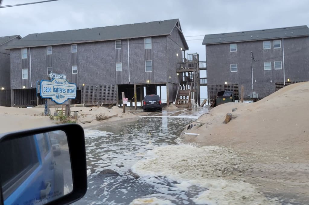
On the morning of September 9, 2025, Hatteras Island residents and visitors woke up to a familiar but unsettling scene: waves pushing seawater across parts of N.C. Highway 12, salt spray dancing in the air, and an advisory from the National Weather Service (NWS) warning of minor coastal flooding.
At 6:30 a.m. in northern Buxton, just a few hours before the morning high tide, minor ocean overwash was already spotted. While not unusual for this stretch of the Outer Banks, it’s a reminder of how delicate life between ocean and sound can be. By 7:00 a.m., N.C. Highway 12—the island’s lifeline—was still open, but motorists were urged to drive cautiously.
With higher astronomical tides combining with strong northeast winds, Hatteras and Ocracoke Islands are bracing for conditions that could affect travel, safety, and daily routines. And while locals are used to adapting, every overwash is a story of resilience, caution, and community readiness.
The Science Behind the Overwash
To understand what happened on Hatteras Island today, you need to consider two powerful forces at play:
Astronomical Tides – These are naturally higher around full moons and new moons, when the gravitational pull of the moon and sun align. September is notorious for “king tides,” when water levels rise higher than normal, even without a storm.
Persistent Northeast Winds – For barrier islands like Hatteras, strong northeast winds act like a hand pushing water toward the shoreline, driving waves and surf inland.
The combination of the two set the stage for minor flooding along vulnerable spots on N.C. Highway 12, the only road in and out of much of Hatteras Island.
Local Impact: Highway, Ferry, and Travel Concerns
1. N.C. Highway 12
While the highway remained open as of early Tuesday, officials reminded drivers that saltwater isn’t just water—it’s corrosive. Driving too quickly through standing water can splash saltwater onto brake lines, undercarriages, and electrical systems, leading to costly damage.
Travelers were urged to:
Drive slowly and cautiously.
Avoid large puddles of ocean water.
Rinse vehicles thoroughly after driving through saltwater.
2. Ferry Services
The Hatteras-Ocracoke ferry adjusted its schedule due to the weather. Departures are limited, with Hatteras leaving at 5 a.m., 6 a.m., 8 a.m., 9 a.m., 11 a.m., 12 p.m., 2 p.m., and 3 p.m. Ocracoke ferries are scheduled at 6:30 a.m., 7:30 a.m., 9:30 a.m., 10:30 a.m., 12:30 p.m., 1:30 p.m., and 3:30 p.m.
For islanders who depend on the ferry for work, school, or medical appointments, these adjustments mean reshuffling daily plans. Tourists hoping for a spontaneous trip to Ocracoke may find themselves stuck waiting hours—or even days.
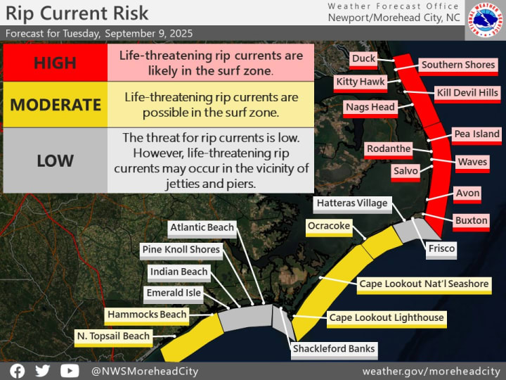
3. High Rip Current Risk
The National Weather Service also issued a high rip current risk from Cape Point in Buxton up to the northern Outer Banks. Swimmers are strongly discouraged from entering the ocean, as rip currents can be deadly even for strong swimmers.
Why Minor Overwash Still Matters
Some may wonder: If the flooding is “minor,” why the concern?
The answer lies in cumulative effects. Each overwash event contributes to:
Erosion of sand dunes and protective berms.
Damage to N.C. Highway 12, which requires constant maintenance.
Saltwater intrusion into freshwater systems and vegetation.
Moreover, overwash events are indicators of larger climate challenges. The Outer Banks is one of the most vulnerable regions in the United States when it comes to sea-level rise. What is minor today could become major in the decades ahead.
Voices from the Island
Locals, used to the rhythm of the sea, shared mixed reactions:
Fishermen in Buxton noted how the shifting tides made launching boats more challenging.
Parents in Hatteras Village worried about getting kids to school on time with ferry delays.
Tourists renting beach houses were reminded that the beauty of the Outer Banks comes with unpredictability.
One resident put it simply:
“Living here means respecting the ocean. It gives us everything, but it also takes back what it wants.”
The Bigger Picture: Weather and Climate
September has historically been a volatile month for the Outer Banks. It sits squarely in the peak of Atlantic hurricane season, and even when a named storm isn’t near, distant systems can whip up swells and impact local tides.
This week’s advisory is a reminder of:
The fragile balance between land and sea.
The importance of preparedness for both residents and visitors.
The reality of living on barrier islands—roads, homes, and businesses are always at the mercy of nature.
Practical Advice for Visitors and Residents
If you’re on Hatteras or Ocracoke during a Coastal Flood Advisory, here’s how to stay safe:
Check the forecast frequently. The NWS office in Newport/Morehead City updates advisories regularly.
Plan travel around tides. If possible, avoid driving N.C. Highway 12 during high tide.
Heed rip current warnings. No beach day is worth risking your life.
Keep essentials stocked. Ferries and roads can close quickly, cutting off supply lines.
Document conditions. Photos of overwash help officials and scientists track changes.
FAQs
Q: Is N.C. Highway 12 closed right now?
A: As of 7:00 a.m. on September 9, 2025, the highway is still open, but drivers are urged to be cautious.
Q: Can I still take the ferry to Ocracoke today?
A: Yes, but on a limited schedule. Always check for updates before heading to the terminal.
Q: What should I do if my car drives through saltwater?
A: Rinse the undercarriage immediately to prevent long-term corrosion.
Q: How dangerous are rip currents right now?
A: Extremely dangerous. A high risk is in effect, meaning swimmers should stay out of the ocean.
Looking Ahead
The Coastal Flood Advisory for Hatteras Island remains in effect until noon today. Conditions are expected to improve slightly as tides shift, but with persistent northeast winds, localized overwash may continue through the week.
Residents, businesses, and emergency officials will continue to monitor the situation closely. For now, life on the Outer Banks continues—with one eye always on the horizon.
SEO Optimization Notes
Primary keywords: Hatteras Island flooding, Coastal Flood Advisory, Outer Banks weather, N.C. Highway 12 overwash, Hatteras ferry schedule, Buxton flooding.
Secondary keywords: rip currents Outer Banks, Ocracoke ferry September 2025, Hatteras high tide flooding, Outer Banks September weather.
Geo-focus: Hatteras Island, Buxton, Ocracoke, Cape Point, Northern Outer Banks, NC.
Final Thoughts
The story of September 9, 2025, is not just about water crossing a road. It’s about the delicate dance between people and nature on the Outer Banks. Every advisory is a reminder that these islands are constantly reshaped by the forces around them.
For those who call Hatteras home, it’s simply part of life. For visitors, it’s a humbling lesson: the sea is beautiful, but it demands respect.
Stay safe, drive cautiously, and always remember—on Hatteras Island, the tides write the news.
About the Creator
Omasanjuwa Ogharandukun
I'm a passionate writer & blogger crafting inspiring stories from everyday life. Through vivid words and thoughtful insights, I spark conversations and ignite change—one post at a time.
Keep reading
More stories from Omasanjuwa Ogharandukun and writers in Journal and other communities.
Haru Urara, Japan’s Most Lovable Losing Racehorse and the Legacy That Lives Beyond Her Death at 29
On September 9, 2025, Japan lost one of its most endearing cultural icons. Haru Urara, the racehorse that never won a race yet captured the hearts of millions, passed away at the age of 29 at Martha Farm in Chiba Prefecture.
By Omasanjuwa Ogharandukun4 months ago in Journal
The goals I did not achieve
Every writing goal I made for the year is a wash. It has been this way for a while, but I think it's important to be open about my failures and the reality of how life can get in the way. This is especially true considering the several times I have posted on Vocal about my writing goals, how I was changing my approach, and where I was hoping to be for the upcoming year. I will probably do that again in a couple months, but for now, it is time to acknowledge where I am today.
By Kay Husnick24 days ago in Journal
A Comprehensive Guide to Starting a Mental Health Business and Building Client Trust
Introduction: The Rising Demand for Mental Health Services The modern era has witnessed an escalating recognition of psychological well-being as a central pillar of human flourishing. Increasing stressors, social isolation, and rapid technological change have heightened the need for accessible mental health services. Starting a mental health business responds not merely to economic opportunity but to a profound societal imperative. With thoughtful planning and unwavering ethical grounding, such a venture can become both sustainable and transformative, supporting individuals in reclaiming equilibrium and emotional resilience.
By Fida Hassain7 days ago in Journal


Comments
There are no comments for this story
Be the first to respond and start the conversation.