
Hurricane Erin 2025: Category 4 Storm Brings Strong Waves, Flood Threats, and Viral ‘Stadium Effect’
Latest updates on Hurricane Erin 2025 with path, impacts, and viral eye of the storm.

Hurricane Erin 2025 has become a major topic in the United States and around the world. This storm grew quickly in the Atlantic Ocean, reaching Category 5 at its peak before slightly reducing to Category 4. Even though it is not expected to make landfall on the U.S. mainland, its size and intensity have made it a subject of concern and attention.
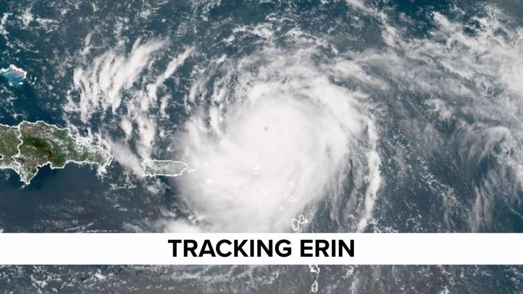
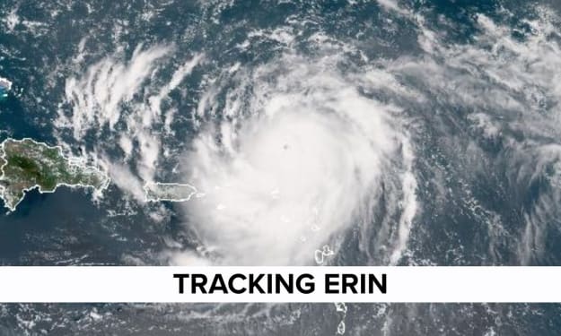
One of the most striking features of Hurricane Erin has been the rare “stadium effect,” a clear view inside the eye of the storm that looked like an open arena surrounded by tall walls of clouds. Videos of this effect have gone viral, making Erin one of the most talked-about storms in recent years. This article explains how Hurricane Erin formed, what threats it brings, the meaning of the stadium effect, and what experts are saying about the storm’s future track.
How Hurricane Erin Formed
Hurricane Erin started as a tropical disturbance over the central Atlantic Ocean. Within a short time, warm sea surface temperatures and favorable weather conditions allowed it to build strength.
Meteorologists first classified Erin as a tropical storm, but it gained intensity quickly. In less than two days, it grew into a Category 5 hurricane with sustained winds above 150 mph. Later, it lowered slightly to Category 4, but remained a very strong storm capable of producing dangerous conditions.
The speed of Erin’s growth surprised many weather experts. It reminded people of past hurricanes that developed rapidly and caused serious concerns across coastal areas.
Current Status of Hurricane Erin
As of the latest updates, Hurricane Erin is located over the Atlantic Ocean, several hundred miles away from the U.S. mainland. While it is not expected to directly hit the East Coast, the storm is close enough to create strong ocean waves, rip currents, and coastal flooding.
Authorities in states like Florida, North Carolina, and New Jersey have issued warnings to beachgoers and residents near the shore. Even without landfall, large storms like Erin can influence tides and create dangerous swimming conditions.
In addition, nearby islands in the Caribbean, such as Puerto Rico and the Virgin Islands, have already seen heavy rain, flooding, and strong winds from Erin’s outer bands.
What is the “Stadium Effect”?
One reason Hurricane Erin has caught worldwide attention is because of the rare “stadium effect.”
When a hurricane becomes extremely intense, the eye of the storm sometimes clears out so much that it looks like the inside of a sports stadium. The center is bright and open, while the walls of clouds rise high around it like stands in an arena.
Satellite images and aerial footage of Erin showed this phenomenon in an almost perfect way. This effect does not happen in every hurricane, which is why it became viral across social media and news outlets. For scientists, it is also a sign of how strong the hurricane’s internal structure really is.
Flood Threats and Coastal Impact
Even though Hurricane Erin may not directly strike the U.S. coast, the risks are still serious.
- Rip Currents: Strong water channels that can pull swimmers far from the shore are expected along the East Coast. These are dangerous for anyone entering the water.
- High Surf: Waves taller than 10 feet in some areas have already been reported, leading to beach erosion and damage to coastal structures.
- Flooding: Low-lying regions near the water could face flooding during high tides, especially if heavy rain from Erin’s outer bands moves inland.
Local authorities have advised residents to avoid unnecessary trips to the beach and to follow safety alerts closely.
Comparison with Past Hurricanes
Hurricane Erin has drawn comparisons with other major storms in Atlantic history. The quick growth to Category 5 strength is similar to storms like Hurricane Maria and Hurricane Irma, which also gained intensity very quickly.
However, Erin’s exact path is different. Unlike storms that made direct landfall and caused large-scale destruction, Erin seems to be tracking northward into open waters. This does not reduce its importance, but it does mean that the mainland impact could be less severe than feared.
Still, experts remind people not to underestimate the risks of flooding, rip currents, and high waves.
Social Media Buzz and Viral Footage
Hurricane Erin became a trending topic not just because of weather warnings, but also because of the viral videos showing the stadium effect. Millions of people have shared images of the storm’s eye, describing it as one of the clearest and most striking hurricane visuals in recent memory.
News agencies, meteorologists, and weather bloggers have also shared constant updates, which has kept Erin in the spotlight. The combination of science, danger, and viral visuals has made this hurricane a major talking point far beyond the regions directly affected.
Expert Warnings and Safety Advice
The National Hurricane Center (NHC) and local weather services continue to track Erin’s path closely. Their advice has been clear:
- Avoid swimming or surfing on beaches affected by Erin’s waves.
- Stay updated with local forecasts.
- Prepare for sudden flooding if living in low coastal areas.
- Remember that outer bands of hurricanes can create tornadoes and severe thunderstorms.
Even if the storm does not make direct landfall, its indirect impact can still be dangerous.
Possible Future Track
Forecast models suggest that Hurricane Erin will continue moving north over the Atlantic. Some paths show it curving away into the open ocean, while others suggest it could bring rain and wind to parts of the U.S. Northeast later in the week.
Meteorologists caution that storm paths can change, and people should not assume safety until Erin is completely out of range. Monitoring official updates is the safest approach.
Why Hurricane Erin Matters
Hurricane Erin 2025 stands out for several reasons:
- Its sudden rise from a tropical storm to a Category 5 hurricane.
- The rare stadium effect that fascinated millions.
- The risks of strong waves, rip currents, and flooding even without landfall.
- The reminder that hurricanes can remain dangerous even when far offshore.
For scientists, Erin is a case study in rapid storm growth. For the public, it is a reminder to stay alert during hurricane season.
Conclusion
Hurricane Erin 2025 has captured worldwide attention as one of the strongest storms of the season. From its quick rise in strength to the viral stadium effect, Erin has combined science, danger, and public interest in one event. Although it may not directly strike the U.S. mainland, its effects are already being felt through large waves, coastal flooding, and risks to beach safety. Caribbean islands have faced heavy rains and floods, while the East Coast watches closely for further impact.
Experts agree that the storm highlights the need for awareness and preparedness. As Hurricane Erin moves through the Atlantic, its story continues to remind us of the power of nature and the importance of staying informed during hurricane season.
About the Creator
The goals I did not achieve
Every writing goal I made for the year is a wash. It has been this way for a while, but I think it's important to be open about my failures and the reality of how life can get in the way. This is especially true considering the several times I have posted on Vocal about my writing goals, how I was changing my approach, and where I was hoping to be for the upcoming year. I will probably do that again in a couple months, but for now, it is time to acknowledge where I am today.
By Kay Husnick17 days ago in Journal
Where's the Glory?
In breaking news, rehabilitated Republican Senator Johnnie Johnson (Pronouns: HE, HIM, HIS) called a press conference from the Men’s room of the New Orleans Louis Armstrong International Airport, Concourse B, across from the Ignatius Reilly’s Lucky Dog stand. The Senator had just returned from a sexual reorientation rehabilitation program in Memphis, TN after being publically disgraced at a Buckee’s Truckstop restroom soliciting sex from an undercover cop three months ago. He is a founding member of the Reformed Christians for Christ, a conservative, pro-family and ex-gay advocacy group. In the spirit of being reborn, Senator Johnson invited reporters to marvel at his plans for a major remodeling of airport bathrooms.
By Cathy Schieffelin5 days ago in Humor


Comments
There are no comments for this story
Be the first to respond and start the conversation.