
Hurricane Erin 2025
Could This Powerful Storm Mimic Past Offshore Hurricanes?

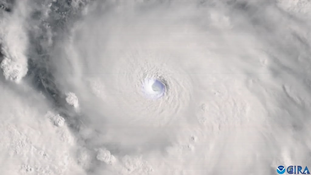
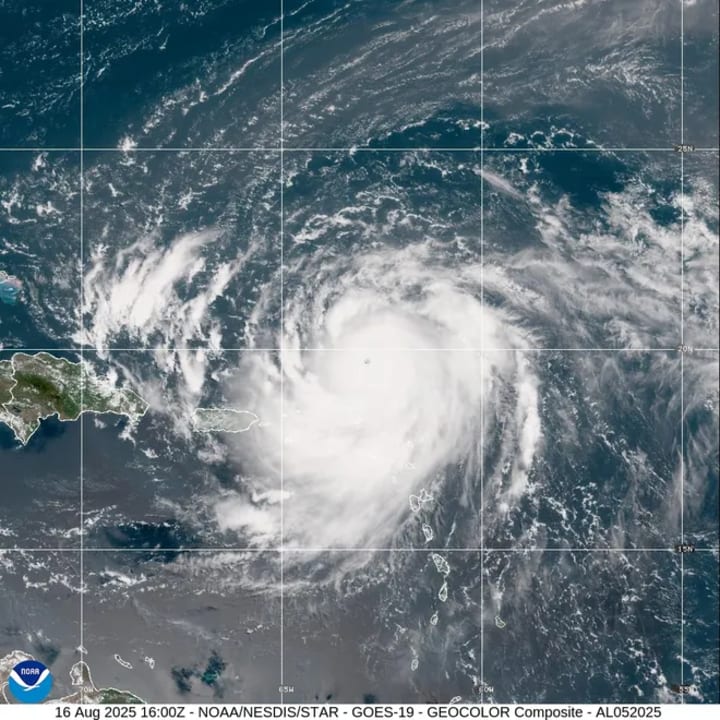
Hurricane season is once again in full swing, and all eyes are on Hurricane Erin, a massive and intensifying storm currently moving northward parallel to the U.S. East Coast. With winds exceeding 160 mph as of August 16, 2025, Erin has already reached Category 5 intensity on the Saffir-Simpson Hurricane Wind Scale. Although early forecasts suggest the hurricane will remain hundreds of miles offshore, meteorologists and coastal residents alike are watching closely, remembering that offshore hurricanes can still leave a costly and deadly mark.
This article explores Hurricane Erin’s trajectory, its potential impacts on coastal communities, and how it compares to previous offshore hurricanes like Bill (2009), Joaquin (2015), and Lorenzo (2019). We’ll also dive into the science of hurricane tracking, why offshore storms still pose threats such as rip currents, erosion, and dangerous swells, and what experts say about future storm risks.
Hurricane Erin’s Current Path
According to the National Hurricane Center (NHC), as of 5 p.m. on August 16, Erin was forecast to be located about 600 miles east of Savannah, Georgia, by August 20. That distance may sound reassuring, but experts warn that the storm’s expanding size and intensity increase the likelihood of hazardous surf, rip currents, and beach erosion along much of the U.S. East Coast.
NOAA meteorologists stress that hurricanes do not have to make direct landfall to cause serious consequences. In fact, over the last decade, 10–15% of tropical storm and hurricane-related fatalities have been attributed to rip currents alone. These strong currents can easily overpower swimmers, surfers, and even experienced lifeguards.
This risk is part of why NOAA launched its new “Blue IQ” public safety campaign earlier this year to raise awareness of ocean hazards associated with tropical storms.
Why Offshore Hurricanes Still Matter
While residents may breathe a sigh of relief that Hurricane Erin is unlikely to follow a Superstorm Sandy-style left turn toward land, offshore storms carry several significant risks:
Rip Currents and Surf Hazards
Strong swells generated by hurricanes can travel thousands of miles. Even beaches hundreds of miles from the storm center can experience life-threatening rip currents.
Past hurricanes like Lorenzo (2019) caused at least eight deaths from rip currents along the U.S. East Coast, despite never making landfall in the continental U.S.
Beach Erosion and Coastal Damage
“Storms like this can be beach eaters,” said Rob Young, Director of the Program for the Study of Developed Shorelines at Western Carolina University.
When large waves batter shorelines for days, sand dunes and beach nourishment projects can be wiped away, costing communities tens of millions of dollars.
Impacts on Shipping and Commerce
Offshore hurricanes may be jokingly referred to as “fish storms,” but as veteran meteorologist Brian LaMarre reminds us, “There’s a great deal more than fish out there.”
The Atlantic shipping lanes are some of the busiest in the world. Disruptions caused by long-period swells can impact global trade, fuel shipments, and fishing industries.
Could Hurricane Erin Turn Toward the Coast?
Meteorologists emphasize that the probability of Erin veering westward toward land is low. Forecast accuracy has improved dramatically thanks to decades of satellite data, advanced computer models, and investment in federal research.
In fact, the NHC reported in March 2025 that its 2024 track forecast performance was the best in history, with an average error of fewer than 50 nautical miles at 48 hours out.
Still, storms have been known to surprise forecasters. Superstorm Sandy (2012) initially looked like an offshore storm before making its devastating turn into New Jersey. For now, the highest risks of tropical-storm-force winds from Erin are in Nantucket, Massachusetts, and Cape Hatteras, North Carolina, though both areas face just a 6% chance of tropical-storm-force winds and a 1% chance of hurricane-force winds.
Offshore Hurricanes in History
Hurricane Erin’s projected path is far from unique. Many past hurricanes have tracked north along the Atlantic, sometimes curving harmlessly away, sometimes leaving scars in their wake.
Hurricane Erin (2001)
The last storm named Erin, in September 2001, also traveled north offshore. A remarkable NASA satellite image on September 11, 2001, captured both Erin swirling east of North Carolina and Virginia and the smoke plume from the terrorist attacks on the World Trade Center.
Hurricane Bill (2009)
Although Hurricane Bill never made U.S. landfall, it caused the deaths of a 7-year-old girl in Maine and a 54-year-old man in Florida due to large waves and rip currents. The storm also triggered coastal flooding and multiple rescues before eventually striking Newfoundland.
Hurricane Joaquin (2015)
Hurricane Joaquin became infamous after the sinking of the SS El Faro cargo ship, which killed all 33 crew members. Even though Joaquin remained offshore, its moisture combined with a low-pressure system over the Southeast U.S., creating historic flooding in South Carolina.
Hurricane Lorenzo (2019)
Lorenzo rapidly intensified in the open Atlantic and produced massive swells that battered the U.S. coastline for days. At least eight people died from rip currents linked to the storm.
Hurricane Erin’s Potential Coastal Impacts
Even without landfall, Hurricane Erin 2025 could leave behind a lasting impact:
Erosion of East Coast Beaches – Renourishment projects worth millions may be undone in days.
Tourism Losses – Dangerous surf could shut down beaches during peak summer travel.
Insurance Claims – Coastal flooding and erosion damage can trigger costly payouts.
Marine Disruptions – Fishing fleets, cruise ships, and cargo lines will reroute to avoid dangerous seas.
Rob Young warns: “Storms like Erin may not knock down homes unless they’re already in the water, but they can do damage to beaches on the order of tens of millions of dollars.”
How Climate Change Shapes Hurricanes Like Erin
Scientists caution that warming oceans and changing atmospheric patterns are increasing the risks of rapid intensification and larger storm sizes. Hurricane Erin grew quickly into a major storm, similar to Lorenzo (2019) and Ida (2021).
Key trends:
- Warmer sea surface temperatures (SSTs) provide more fuel for hurricanes.
- Slower-moving systems increase rainfall and flooding risks.
- Rising sea levels make coastal flooding more destructive, even from offshore storms.
How to Stay Safe During Offshore Hurricanes
- Heed Rip Current Warnings – Avoid swimming in rough surf conditions.
- Stay Updated – Follow the NHC, NOAA, and local weather alerts.
- Protect Property – Secure outdoor furniture, check flood insurance coverage, and prepare for possible flooding.
- Plan for Travel Disruptions – Cruises, flights, and shipping schedules may face delays.
Conclusion: Why Hurricane Erin Still Matters
Hurricane Erin 2025 may never touch the U.S. mainland, but it serves as a powerful reminder that offshore hurricanes are not harmless. With winds surpassing 160 mph, a growing size, and the ability to impact 1,000 miles of coastline with waves, erosion, and rip currents, Erin could easily cause tens of millions of dollars in damage without ever making landfall.
Past storms like Bill, Joaquin, and Lorenzo have shown us that the greatest risks sometimes come from the waves rather than the wind. And with climate change fueling stronger and larger hurricanes, vigilance will remain essential for coastal communities.
As NOAA’s Blue IQ campaign highlights, understanding the risks of offshore storms is just as important as preparing for direct hits. Whether Hurricane Erin turns out to be a “fish storm” or a “beach eater,” its legacy will remind us that every storm deserves respect.
About the Creator
Omasanjuwa Ogharandukun
I'm a passionate writer & blogger crafting inspiring stories from everyday life. Through vivid words and thoughtful insights, I spark conversations and ignite change—one post at a time.
Keep reading
More stories from Omasanjuwa Ogharandukun and writers in Journal and other communities.
Why Apple iPhone 16 and iPhone 16 Pro Prices Slashed Ahead of iPhone 17 Release
With just weeks to go before the highly anticipated iPhone 17 release date on September 19, 2025, Apple’s current flagship lineup — the iPhone 16, iPhone 16 Plus, iPhone 16 Pro, and iPhone 16 Pro Max — is seeing dramatic price cuts across major UK retailers.
By Omasanjuwa Ogharandukun5 months ago in Journal
Golden bag
In a mountainous area far from the town lived a boy named Aaqil with his parents. Eleven-year-old Aaqil was a fifth-grade student. His father worked with a contractor who broke mountains and sent stones to different parts of the country, while his mother did sewing and embroidery for women, and this was how they earned their living. After finishing his studies, Aaqil helped his mother.
By Sudais Zakwanabout 22 hours ago in Journal


Comments
There are no comments for this story
Be the first to respond and start the conversation.