
How to prepare for the trek at High Altitudes in Nepal
It’s true that high-altitude hikes bring unique challenges, but the rewards—breathtaking views, a sense of accomplishment, and the serenity of Nature—make it all worth it. Let’s break down how to prepare for this kind of hike to make sure you’re set up for a successful and enjoyable experience:1.Physical Preparation Acclimate Gradually: If possible, spend a few days at a higher elevation before your hike to help your body adjust to the reduced oxygen levels. Avoid pushing yourself too hard the first day at altitude. Get Fit: A good fitness foundation is key. Cardiovascular exercise, strength training (especially for legs), and flexibility exercises will help you handle the physical strain of a high-altitude hike. Focus on endurance hikes to simulate the time and effort involved. 2. Know the Signs of Altitude Sickness Symptoms: Headaches, nausea, dizziness, shortness of breath, and fatigue are all signs of altitude sickness. If you experience these, don’t push through it. Descend to a lower elevation and rest. Prevention: Stay hydrated, avoid alcohol, and give yourself time to acclimatize. Some hikers use medications like Diamox (consult a doctor for advice) to reduce the risk of altitude sickness. 3. Packing Essentials Clothing: Dress in layers, as the weather can change rapidly at high elevations. Choose moisture-wicking base layers, an insulating mid-layer (like fleece), and a windproof and waterproof outer layer. Don’t forget a hat and gloves, as temperatures can drop unexpectedly. Water and Snacks: Dehydration is more common at higher elevations, so carry plenty of water and electrolytes. High-energy snacks (nuts, energy bars, dried fruit) will help keep your energy up during the hike. Sun Protection: The higher you go, the stronger the UV rays. Pack sunscreen, sunglasses, and a wide-brimmed hat. A good pair of hiking boots with ankle support is crucial for rough terrain. 4. Check the Weather and Trail Conditions High-altitude weather can be unpredictable. Check forecasts frequently, and be prepared for storms, cold, or extreme winds. If conditions look unfavorable, consider postponing or altering your plans. 5. Plan Your Route and Know the Terrain Do thorough research on the trail. Understand the distance, difficulty level, and the elevation gain. High-altitude trails often have steep inclines and rocky paths, so be prepared for challenging terrain. 6. Hydration and Nutrition Hydration: The dry air at high altitudes can lead to dehydration faster than at sea level. Drink water regularly, even if you don’t feel thirsty. Consider carrying a hydration system like a Camelbak for easy sipping. Nutrition: Your body will burn more calories at higher elevations due to the increased exertion. Carry lightweight, calorie-dense snacks to fuel your hike. Foods like nuts, jerky, and energy bars are great options. 7. Mental Preparation Pace Yourself: High-altitude hiking requires patience. Take your time and listen to your body. Rest when needed, and don’t rush to the summit. Stay Positive: The conditions can be harsh, but keeping a positive mindset and remembering why you wanted to do the hike in the first place can be a huge motivator. 8. Get Familiar with the Route Research the Terrain: Know the trail conditions, expected weather, and any potential hazards (like river crossings, steep ascents, or rocky paths). Guided Trek vs. Self-Guided: Consider hiring a guide if you’re not familiar with trekking at high altitudes, especially in remote or challenging regions. 9. Know When to Turn Back Sometimes, despite all the preparation, the conditions may just not be right, or your body may not be adjusting as expected. It’s essential to know when to call it quits—your safety is the most important thing. 10. Emergency Plan Make sure someone knows your hiking itinerary. Carry a map, compass, or GPS device, and consider bringing a satellite phone or a personal locator beacon (PLB) in case of an emergency. Conclusion Himalayan Sanctuary Adventure only suggest you to follow these tips, you’ll not only increase your chances of a safe and enjoyable high-altitude hike, but you’ll also be able to appreciate the unique beauty that comes with hiking in elevated terrains
Day 01: Arrival at Tribhuvan International Airport (TIA), Kathmandu & Transfer to Hotel
After you land, one of the representatives from Himalayan Sanctuary Adventure will be waiting to receive you at the airport. After a brief introduction, you will head towards the hotel in Thamel. After some rest, visit us at our office. We will introduce you to our staff and guides for the Manaslu Trek.
Overnight at Kathmandu.
Day 02: Trek Preparation and Explore Kathmandu Valley(4 – 6hr)
Today first you will explore numerous UNESCO world heritage sites in Kathmandu. These include the Swyambhunath Stupa, Pashupatinath Temple, Boudhanath Stupa, Kathmandu Durbar Square and, many other places. It will be a mesmerizing moment here in Kathmandu to witness the beauty of nature, and different cultures with different temples, architecture, and monuments. End of the day you will be well prepared for the Manaslu trip with the required stuff needed during the trip.
Overnight at Hotel
Day 03: Drive to to Machha Khola (930 m / 3,051 ft)8 – 10 hrs.
It will take about seven hours to reach Arughat from Kathmandu. Our journey will begin early in the morning after breakfast. You’ll drive along the Highway to Arughat than to machhakhola through beautiful paddy fields, Warm villages following the Budhi Gandaki River, and climb over and down Kyoropani to the Budi Gandaki junction and the Soti Khola to machhakhola. Although the path is rough, you will the witness the stunning scenery of the countryside view that will be more engaging.
Driving Distance – 160 km / 99 miles
Overnight at a Teahouse/lodge
Day 04: Machha Khola to Jagat (1,340 m /4,396 ft):
We resume our journey from Machha Khola following Tharo Khola through the narrow path and finally to Khorla Besi. After a few times will reach the most popular hot spring, Tatopani. We can relieve our stress and tiredness by taking a hot bath in Tatopani. Then we will cross the Suspension bridge of the Budhi Gandaki River to reach Thado Bharayag. Walking along the river we will reach Jagat village.
Trek Distance – 14 km / 8.6 miles
Overnight at a lodge/teahouse
Day 05: Trek toward Deng ( 1,804 m / 5,918 ft)
Resuming our trek, initially, we climbed a rocky cliff towards Siribas and continued toward Ghatte Khola. Crossing the suspension bridge we’ll reach Philim village, the settlement of the Gurung community. You will have lunch and continue your journey from grassy slopes and some cliffs to cross over Budi Gandaki to reach a small village called Deng. We will rest for the day here.
Trekking Distance – 19.9 km / 12.3 miles
Overnight at a Teahouse/lodge
Day 06: Deng Village to Namrung (2,630 m / 8,628 ft)
We begin our trip by crossing over the Budhi Gandaki Bridge to climb a bit far to join the trail from Bhi. Headed through the forest, green valley, and houses of ethnic groups of the Manaslu region. The trail was then processed to Ghap through several landscapes. You should follow the instruction of your guide and be extra concerned about the path. After all the obstacles we finally reach up to Namrung Village. After a wonderful sunset from the village, we will rest for the day.
Trekking Distance: 20 km / 12 miles
Overnight at a Teahouse/lodge.
Day 07: Namrung to Samagaun ( 3.530 m / 11,581 ft)
We’ll aim to reach Samagaun from Namrung, We start our trip from Namrung to pass through Banjam, Lihi, Sho, Lho, and Sayla. We are about to witness the view of the Monastery before reaching Lho. Heading toward the Lihi, there will give you a view of Ganesh Himal, Naike Peak, and Himchuli Peak. Continue our trek, it takes 1 hour and 30 minutes to reach Lho next 2 hours to reach Sayla from Lho. While on Sayla, we will witness the views of Nadi Chuli, Manaslu, Himalchuli, Manaslu, Nike Peak, Siring Himal, and more. We’ll reach Samagaun in the afternoon.
Overnight at a lodge/Teahouse
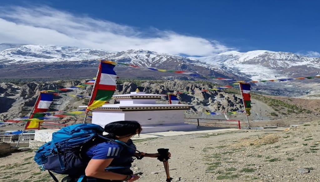
Day 08: Acclimatization at Samagaon.(Manaslu Base Camp or Pungyen Gompa): 6 – 7 hours of exploration
Today you will explore the Samagaun Village, you are about to know the traditional and cultural Monasteries, as well as the geographical cultivation such as potatoes and barley, flourish. Most people prefer to wear woolen clothes made up of sheep’s wool and involve in the manufacture of blankets, and rugs for trade. Monasteries have impressive designs and carvings which reflect the history of Tibetan settlers. There exist 8 different monasteries and among them, Pemba Chholing Gompa is the largest. You can witness the wonderful view of Manaslu, as well as the beautiful lake that lies, ascend of monasteries. After trekking for 5-6 hours, we will arrive at Manaslu Base Camp. You can also visit Pungyen Nunnery (3870m) lies above Pungyen Glacier.
Trekking Distance: 11 km / 6 miles
Day 09: Samagaun to Samdo (3,865 m / 12,680 ft):
Resuming today’s trek descends towards Budi Gandaki. The journey is relatively easy and it lies above the self above the Gandaki River. You will get to see the stone arch and plane granny land before you enter the village. Attractive place, get to see yaks and goats around the fields and the stunning view of Samdo Peak (6335m). In about 4-5 hours, we will be in Samdo village.
Trekking Distance: 10 km / 6 miles
Overnight at a Teahouse/lodge
Day 10: Acclimatization Day (Day Trip to Tibet Border)5,000 m / 16,404 ft 6– 8 hrs
Day 11: Samdo to Dharmashala (4,460 m / 14,632 ft): 3 – 4 hour
We start our day trek by crossing over the Budi Gandaki River after some ascending hike you will be seeing a glimpse of the Larkya glacier. Visiting around the valley and a way upward again to reach the Dharmashala.
Distance: 3 km / 1 miles
Overnight at a lodge/teahouse
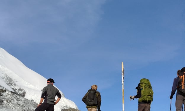
Day 12: Dharmashala to Bimtang via Larkya La (5106m):
New d1y toward a new destination, after breakfast we headed toward Larkya glacier in the north direction offer a clear view of Larkya Peak and Cho Danda. From here we start the trek to reach Larkya La Pass which is the highest point of our whole trek. The climb is challenging and in some steep sections, you should follow the instructions of the guide properly. One can have a panoramic view from the Pass. After some time here, we’ll start our long descent to Bimthang. Rest for the day after reaching Bimthang village.
Trek Distance –24.7km / 15.3miles
Overnight at a lodge/teahouse
Day 13: Bimtang to Dharapani(1,970 m / 6.463 ft): 6 – 8 hour
Today, we descend to Dhud Khola. We cross through the forest full of Rhododendron and pine to reach Dharapani, where we put off for a night’s stay. As the last walking day of the Manaslu Circuit, you will have plenty of scenery to enjoy throughout the trail.
Trek Distance – 15.5km / 9.6miles
Overnight at a teahouse/lodge
Day 14: Back to Kathmandu from Dharapani ( 8 – 10hr)
We will catch a Jeep from Dharapani to Besisahar and we drive from Besisahar to Kathmandu by Local Bus. After the successful trek, we will transfer you to your hotel. Rest for a while and join us for a farewell dinner. Share some stories and feedback as well for the team.
Driving Distance – 224km / 139miles
Overnight at a hotel in Kathmandu.
Day 15: Departure Day
On your last day in Nepal, head out for a brief souvenir shopping session near the hotel in Thamel Market. We will pick you up from the hotel and transfer you to TIA before the departure. The Manaslu circuit will remain with you forever alongside the lifelong memories and experiences from the trek with Himalayan Sanctuary
About the Creator
Keep reading
More stories from Bishnu Bhatta and writers in Journal and other communities.
Best Trek in Nepal for 2025
1. Everest Base Camp Trek Everest Base Camp Trek Everest Base Camp Trek is the most prevalent trekking destination. The base camp trek is a dream for many travelers around the world. A lifetime memorable experience for travelers to witness the breathtaking views of the world’s highest mountain sceneries. The journey to the base camp trek is full of an impressive landscape, beautiful peaks, and glaciers, ancient monasteries, and snow-capped mountains.
By Bishnu Bhatta 10 months ago in Journal
📢 Raise Your Voice Thread: 01/22/2026
Our “Raise Your Voice Threads” are hosted most alternating Thursdays at 12PM ET to offer creators more avenues to uncover exceptional stories on Vocal. As we are continuously searching for fresh creators and inspiring stories, this thread provides an opportunity to exchange and discuss the stories that have moved and motivated us on Vocal.
By Raise Your Voice by Vocal2 days ago in Resources


Comments
There are no comments for this story
Be the first to respond and start the conversation.