
A Wild Week of Weather Is Coming to the U.S.
The United States is about to face one of the wildest weeks of weather in recent memory. Severe thunderstorms, tornadoes, winter storms, and flooding are all expected. Millions of people need to get ready for what’s coming.

Two Big Severe Weather Events
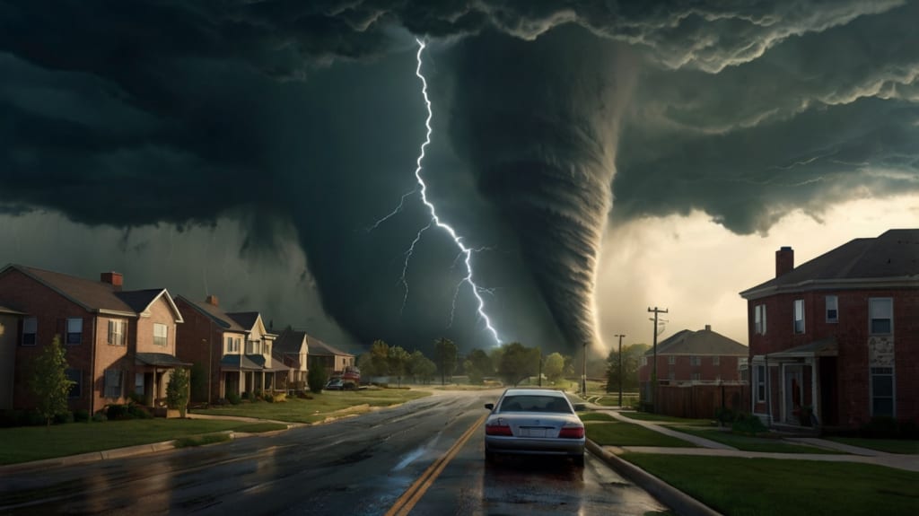
This week will bring two major rounds of severe weather. The first happens on Sunday, March 30th. A powerful storm system will sweep across the central and eastern U.S. The Storm Prediction Center (SPC) says this event is highly dangerous. A large area from Ohio to Texas is at risk. Cities like Cincinnati, Louisville, Nashville, Memphis, St. Louis, Indianapolis, and Little Rock are in the danger zone. Over 100 million people are under some level of threat, including parts of Canada like Toronto. The SPC has also warned that EF2 to EF5 tornadoes could happen, showing how serious things are.
This severe weather is caused by a dip in the jet stream pushing energy over the Plains. This creates perfect conditions for supercells. These storms will pull moisture from the Gulf of Mexico, giving them plenty of fuel. In some areas, instability levels could exceed 3,000 joules per kilogram. To put it simply, values above 1,500 are usually enough for strong storms. Add strong wind shear—winds changing speed and direction with height—and you get rotating storms capable of producing tornadoes.
Timing matters. Early Sunday, showers and clouds may limit instability. But if skies clear in the afternoon, storms could explode. Supercells are likely to form by late afternoon or early evening. They’ll hit areas like southern Indiana, Kentucky, Tennessee, Missouri, Arkansas, and Illinois. These storms could bring tornadoes, damaging winds, and baseball-sized hail. Overnight, the threat shifts to widespread destructive winds, especially farther east.
Another severe weather outbreak is expected just days later, on Wednesday, April 2nd. Early models suggest this event could be worse than Sunday’s. Areas recently hit by storms may face them again. Cities like Indianapolis, Louisville, Memphis, and St. Louis could be impacted. With more moisture and stronger dynamics, this system could bring violent tornadoes and other dangers.
As the cold front from Sunday’s storm pushes eastward on Monday, March 31st, it will spark new storms from New York to the Gulf Coast. In northern states, damaging winds will be the main threat. In the Southeast—especially in the Carolinas, Georgia, and Florida—discrete supercells could spawn isolated tornadoes. If the sun breaks through before the front clears the coast, daytime heating could make the atmosphere unstable again, increasing the risk of severe weather.
Flooding Risks Across the South
Heavy rain is another big concern. Slow-moving storms on Sunday could dump several inches of rain across the southeastern U.S., worsening existing flood risks. Creeks and rivers are already swollen in many areas, and more rain could cause flash flooding. The threat extends into Monday as the cold front continues to push eastward, bringing more rain to parts of the Northeast and Southeast.
While the northern states face primarily damaging winds, the Southeast could see discrete supercells capable of spawning isolated tornadoes. If the sun emerges before the front clears the coast, daytime heating could destabilize the atmosphere, increasing the risk of severe weather. This pattern shows why it’s important to stay alert throughout the weekend and into the early part of the week.
Winter Weather Challenges in the North
While the South deals with severe weather, the northern U.S. faces its own challenges. Parts of Minnesota, Wisconsin, Michigan’s Upper Peninsula, Southern Ontario, and the Northeast are under ice storm warnings and winter storm watches. Warm and cold air masses will collide, creating freezing rain. Some areas could see up to an inch of ice buildup, which can damage infrastructure, cause power outages, and disrupt travel. Even smaller amounts of ice can have serious impacts, particularly in rural areas where recovery takes longer.
Areas just north of the ice zone, like Vermont and New Hampshire, will receive heavy, wet snow—up to six inches in some spots—along with glaze icing. Downed trees and power lines will add to the problems caused by the weight of the precipitation. Residents in these regions should prepare for potential power outages that could last days and ensure they have supplies to endure prolonged disruptions.
Fire Weather Dangers in the West
Dry air and strong winds are making wildfires more likely in parts of the western U.S. The biggest risks are in New Mexico and Texas, but higher chances of fires are also expected in areas like Philadelphia and Washington, D.C. People in these regions should be careful and avoid doing anything that could start a fire during this risky time.
Looking Ahead: A Pattern of Extremes
After this wild week, the weather isn’t calming down anytime soon. The eastern U.S. will stay warmer than usual, while the west will be cooler. This pattern will keep storms moving across the country. Over the next six to ten days, the Mississippi River Valley is likely to get more rain than normal, which means flooding could still be a problem in April. However, there’s some good news for the Southwest. Closer to April 7th, rain is expected to arrive, bringing much-needed relief to dry areas.
How to Stay Safe
With so many hazards converging, preparation is key. If you’re in the path of severe weather, find safe shelter ahead of time, such as basements, storm cellars, or interior rooms without windows. Stay informed by checking local news outlets and NOAA weather radios for updates. Stock up on essentials like water, non-perishable food, flashlights, and batteries to be ready for emergencies.
If you’re expecting winter weather, make sure you have enough food, medications, and emergency items to last several days. Insulate exposed plumbing to prevent frozen pipes, and keep phones and electronics fully charged in case of prolonged power outages. Share information with friends and family so everyone knows what’s coming and how to stay safe.
Conclusion
This week reminds us how powerful and unpredictable nature can be. Whether facing tornadoes, torrential rains, icy roads, or wildfires, communities must work together to reduce risks and support one another. As meteorologists track these systems, staying vigilant and prepared will help people handle whatever comes their way. By understanding the threats and taking proactive steps, we can navigate this wild week of weather with confidence.
About the Creator
Keep reading
More stories from Anna-Maria and writers in Humans and other communities.
Valentine's Day: The Holiday That Makes Everyone Question Their Life Choices (But Also Kinda Rocks)
Step 1: The Card Dilemma First off, cards. Oh, the infamous cards. You walk into that store thinking, “I’ll find something cute and funny,” but instead, all you see are cheesy poems written by someone who clearly hasn’t been on a date since the '90s.
By Anna-Mariaabout a year ago in Humans
How Singles Overcome Social Anxiety While Meeting Potential Romantic Partners
Social anxiety may pose a considerable challenge to the singles who want to have relationships. It can usually be seen in the form of fear of being judged, being self-conscious and being reluctant to socialize, such as during a dating outing or during an online chat. It is important to realize that such feelings are a shared experience and not an individual weakness to overcome them.
By Willian James2 days ago in Humans


Comments
There are no comments for this story
Be the first to respond and start the conversation.