
How Surveying Companies Can Profit from Point Cloud to BIM
Point Cloud to BIM for Surveying Companies: Benefits, Workflow & Challenge

The surveying industry is undergoing a significant transformation, shifting from traditional 2D drawings to intelligent 3D models. As the demand for digital twins and reality capture grows, the integration of point cloud to BIM for surveying companies has become a critical service offering. This process involves converting high-precision laser scan data into information-rich Building Information Models (BIM), enabling surveyors to deliver greater value to clients in the Architecture, Engineering, and Construction (AEC) sectors.
By adopting this workflow, surveying firms can transition from data collectors to integral strategic partners in the building lifecycle. However, mastering the transition from raw scan data to a polished Revit model requires specific expertise and resources. This article explores the benefits, workflows, challenges of this technology such as managing massive file sizes, and answer common questions to help your firm successfully implement this lucrative service.
Benefits of Point Cloud to BIM for Surveying Companies
Adopting Point Cloud to BIM allows surveying firms to transition from data collectors to integral partners in the building lifecycle. By converting raw laser scan data into intelligent 3D models, surveyors can meet the growing AEC demand for digital twins, securing a competitive edge in a market that increasingly favors information-rich deliverables over traditional documentation.
Key advantages of integrating this workflow include:
- Higher-Value Deliverables: Instead of providing simple 2D CAD drawings or raw point clouds that clients often struggle to process, delivering a fully parametric Revit model (.RVT) allows surveyors to command a premium fee. This solves a major processing pain point for architects and facility managers, positioning the surveying firm as a high-value solution provider rather than a commodity service.
- Reduced Site Re-visits: Comprehensive laser scanning captures the entire scene in millions of data points, creating a complete "reality capture" of the site. This ensures that no detail is missed during the initial fieldwork. If a client requires additional dimensions or overlooked details later, surveyors can extract this information directly from the digital model without the costly logistics of deploying a field crew back to the physical location.
- Enhanced Accuracy and Risk Mitigation: Translating high-precision scan data into BIM eliminates the ambiguity and human error associated with manual measurements. By accurately modeling "as-built" conditions, surveyors help identify potential issues early in the process, such as structural deformations or hard clashes. This level of detail drastically reduces construction errors and "unanticipated field costs" for the end client.
- Improved Collaboration: A unified BIM model serves as a "single source of truth" that aligns all project stakeholders, from engineers to contractors. Providing data in this format facilitates smoother integration into modern workflows like Integrated Project Delivery (IPD). This connectivity ensures that the data provided by the surveyor remains central to decision-making from the pre-design phase through to facility management.
The Point Cloud Scan to BIM Workflow for Surveyors
Transitioning from raw scan data to a polished BIM model involves a structured, four-step process. Mastering this workflow is essential for surveying companies aiming to produce professional-grade deliverables.
Step 1: Data Acquisition (Laser Scanning)
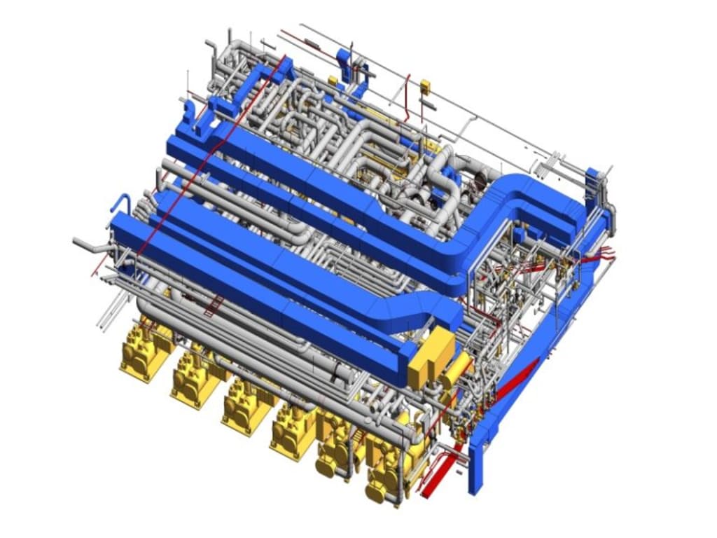
The process begins on-site with data capture. Surveyors use Terrestrial Laser Scanners (TLS) or mobile scanners (like the Leica BLK2GO) to emit laser beams that measure the distance to surfaces. These devices rotate 360 degrees to capture the environment, generating a dense cloud of measurement points with specific X, Y, and Z coordinates. For complex projects, this phase ensures that every structural beam, MEP system, and intricate detail is recorded.
Step 2: Point Cloud Registration and Processing
Once the data is captured, the raw scans must be processed. This step, known as registration, involves stitching multiple individual scans together to form a complete, 360-degree representation of the project site.
- Alignment: Software identifies common features or targets between scans to align them into a single coordinate system.
- Noise Removal: The raw data is cleaned to remove "noise" and reflections (such as moving people or passing cars) that could degrade data quality.
Output: The result is a unified point cloud file (often in formats like .RCP or .E57) that serves as the foundation for modeling.
Step 3: 3D BIM Modeling (Revit/ArchiCAD)
This is the core "Scan to BIM" phase where the "dumb" points are converted into "intelligent" geometry.
- Importing Data: The processed point cloud is imported into BIM authoring software like Autodesk Revit or Graphisoft ArchiCAD.
- Parametric Modeling: Modelers do not just trace lines; they use the point cloud as a reference to place parametric families. For example, instead of drawing a generic box, a specific Revit family is used to represent a window or door that accurately fits the scanned dimensions.
- As-Built Verification: Modelers snap new geometry directly to the point cloud data points, ensuring the digital model reflects the actual physical reality rather than theoretical design values.
Step 4: Quality Control (QC) and Deliverables
The final step ensures the reliability of the model.
Deviation Analysis: QC specialists perform a deviation analysis by overlaying the generated BIM model against the original point cloud. This verifies that the modeled elements sit within the required tolerance (e.g., LOD 300 with ±10mm accuracy).
Clash Detection: The model is checked for "hard clashes" or interferences between systems, such as a duct hitting a beam, to ensure constructability.
Final Handoff: The validated model is delivered to the client, often accompanied by 2D floor plans, sections, and elevations derived directly from the 3D model.
3 Major Challenges in Point Cloud to BIM conversion
While the benefits are clear, surveying companies must navigate several technical hurdles to implement this workflow successfully.
Managing Large Data File Sizes
Point cloud datasets are massive, often reaching terabytes in size. These unstructured datasets can be difficult to store, transfer, and process. Managing this data requires robust infrastructure, such as cloud-based Common Data Environments (CDE) or high-capacity local servers, to prevent bottlenecks in the workflow.
Dealing with Occlusions and Noise
A laser scanner can only capture what it can "see." Objects like furniture, machinery, or debris can block the laser, creating "shadows" or data gaps known as occlusions. Furthermore, reflective surfaces like mirrors or glass can create "noise" or false points. Modelers must be skilled enough to interpret these gaps and reconstruct the missing topology accurately without over-relying on guesswork.
High Hardware Requirements
Processing point clouds and running BIM software simultaneously is computationally intensive. It places a significant strain on hardware, requiring powerful workstations with high-end Graphics Processing Units (GPUs) and substantial RAM. For smaller surveying firms, the initial investment in this specialized hardware and software can be a barrier to entry.
FAQs
What software is best for Point Cloud to BIM?
The industry standard for Point Cloud to BIM is Autodesk Revit, favored for its robust parametric modeling capabilities and widespread adoption in the AEC sector. Autodesk ReCap is essential for the pre-processing and registration stage. For architects, Graphisoft ArchiCAD is also a powerful alternative that handles point cloud data effectively.
What is the accuracy level?
The accuracy of a Scan to BIM model typically ranges from ±2mm to ±6mm for high-precision applications, though this depends on the scanner used and the project requirements. Standard projects often aim for a tolerance of +/- 10mm to ensure the digital twin is a reliable reflection of as-built conditions.
The transition from simple data capture to intelligent modeling is redefining the role of the modern surveyor. Embracing the Point Cloud to BIM workflow is no longer just a technical upgrade; it is a strategic necessity for firms aiming to remain competitive and profitable in a digitizing AEC sector.
While the transition involves overcoming technical hurdles like hardware costs and learning curves, the return on investment is undeniable. Whether you choose to build these capabilities in-house or partner with specialized modeling experts, the time to integrate Scan to BIM into your workflow is now. Start turning your data into insight, and lead the way in the era of digital construction.
About the Creator
ViBIM - Scan to BIM service provider
ViBIM is a trusted Scan to BIM Modeding outsourcing with over a decade of experience, delivering accurate as-built models to clients across the US, UK, Australia, Canada and EU.
Keep reading
More stories from writers in FYI and other communities.
I Preached an Entire Sermon Based on Only One Word
As an itinerant preacher, I was invited to preach at a church for its Missionary Sunday. I chose to preach on a practical subject in keeping with the occasion. Even though the sermon was geared toward missionaries, it was appropriate for everyone who heard it.
By Margaret Minnicks5 days ago in FYI
My New Book is Finally Here
My poetry collection Beautiful and Brutal Things is done. It's actually done and finally published over 270 pages. Over a year of my life went into this book. More than a year, really. Long days at my computer, sometimes seven days a week because I couldn't stop even when I probably should have. Then two months of editing that felt harder than the writing itself. But it's finished, and I'm still standing, and the book is real.
By Tim Carmichael3 days ago in BookClub


Comments
There are no comments for this story
Be the first to respond and start the conversation.