
Mars's mysterious ridges reveal a surprising past.
What Mars was, and perhaps what it was capable of.

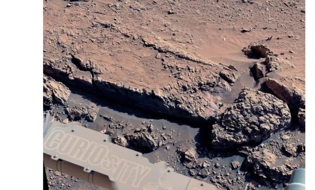
A new area with unique rock formations was recently reached by NASA's Mars Curiosity rover. These crisscrossing ridges, called "boxwork patterns," are unlike anything that has ever been observed on the Red Planet, and Curiosity is now getting its first up-close look.
Big questions about what was going on on Mars billions of years ago are being raised by the new data and photographs.
Originally having lakes, rivers, and possibly even an ocean, Mars eventually lost its surface water and turned into the modern-day frozen desert. The latest research, however, raises the possibility that water may have persisted below long after surface lakes disappeared.
Exploring the Martian ridges
In Gale Crater, the rover's landing location and long-term exploration zone, scientists at the Jet Propulsion Laboratory (JPL) have been examining these boxwork patterns. The lakes of Gale Crater had long since dried up by the time this area formed. However, the fresh data indicate that groundwater was still flowing.
Short, intersecting ridges in the shape of a box were found by the rover; scientists believe these ridges originate when minerals accumulate in rock fissures as water seeps through them.
The cemented, cement-like ridges were left behind as the wind on Mars gradually eroded the softer rock surrounding these mineral-filled fissures.
The riddle of the ridges on Mars
Mount Sharp is a three-mile-tall mountain that Curiosity has been ascending since 2014. The ridges, which resemble broken curbs, extend for miles along the mountain's sides.
Why the ridges were formed into these large patterns and why only here is a major question, according to Ashwin Vasavada, a scientist with the Curiosity team. "As we proceed, we will be examining the ridges and mineral cements to ensure that our understanding of their formation is accurate," Vasavada said.
The layers of Mars' story
The rock layers that make up Mount Sharp each tell a tale from a distinct era of Mars' environment. From earlier, wetter times at the bottom to drier times at the top, Curiosity is essentially travelling through time as it ascends.
Magnesium sulphates, which are salty minerals created when water evaporates, are abundant in the stratum the rover is now in. That implies that this portion of the mountain evolved during a period of dryness, but Mars then presented researchers with yet another challenge.
The bedrock between the boxwork ridges has a different chemistry than other parts of Mount Sharp. Additionally, it has tiny fissures that are lined with dazzling white strands of calcium sulphate, another salty mineral that water has left behind.
Looking out over an area full of boxwork patterns—low ridges that scientists believe may have been created by groundwater billions of years ago—NASA's Curiosity Mars rover took this picture.
Further down the mountain, in older, clay-rich layers, these veins of calcium sulphate had been widespread. However, until now, they had not been observed in this sulfate-rich region.
Abigail Fraeman, deputy project scientist for Curiosity, said, "That's surprising." There used to be calcium sulphate veins everywhere, but when we ascended Mount Sharp, they essentially vanished. The team is eager to discover why they have returned at this time.
Searching for evidence of a previous life
On June 8, Curiosity drilled a rock known as "Altadena" to get to the bottom of this. For a thorough investigation, the drill's powder was put into the rover instruments. The experts are interested in learning more about this unusual terrain's chemical composition and how it differs from previous layers.
Additionally, the team intends to drill additional samples from regions with more extensive boxwork patterns. The mineral cement in these materials may have preserved organic molecule residues or other indications of past life.
Mapping Mars Curiosity involves more than just gathering data from the driest locations on Earth. Additionally, its map is being renamed. To aid scientists in tracking features, the rover is given nicknames for each location it visits.
Until now, those names were taken from Southern California locations close to JPL. For instance, the adjacent town that was damaged by a wildfire earlier this year is the inspiration behind the name of the "Altadena" rock.
However, the naming concept has shifted when Curiosity entered a new phase of its Martian adventure. The group is selecting names from portions of Chile's Atacama Desert and Bolivia's Salar de Uyuni, the largest salt flat on Earth. Astrobiologists frequently study these as Mars-like environments because they are among the driest on Earth.
New enquiries concerning the history of Mars
The questions remain more numerous than the answers. Why are the boxwork patterns limited to this area? At this elevation, why have calcium sulphate veins resurfaced? What can we learn about the final days of water on Mars from these mineral fingerprints?
Eventually, curiosity solves these riddles. Every new ridge, picture, and sample brings us one step closer to comprehension.
About the Creator
Keep reading
More stories from Francis Dami and writers in Futurism and other communities.
For the first time ever, scientists are able to teleport between quantum computers.
There is a catch to the promise of quantum computing: the more qubits you put into a single system, the more difficult it is to keep them in line. Researchers have attempted error correction, shielding, and even stacking qubits on top of each other, but stability continues to elude them.
By Francis Dami9 months ago in Futurism
Australia Animal Feed Market: Livestock Expansion, Nutrition Innovation & Aquaculture Growth
According to IMARC Group, the Australia animal feed market reached USD 11.0 Billion in 2025 and is projected to grow to USD 13.9 Billion by 2034, exhibiting a compound annual growth rate (CAGR) of 2.60% during 2026–2034. The steady expansion of the market reflects the increasing scale of livestock production and the rising importance of scientifically formulated feed solutions across Australia. Producers are focusing on high-quality feed formulations that enhance animal growth, productivity, and disease resistance. In addition, growing export demand for premium meat and dairy products is strengthening Australia animal feed market share. Innovations in feed technology, expanding aquaculture production, and rising awareness about animal nutrition are shaping the future of the industry.
By Kevin Cooper6 days ago in Futurism
Cell Dissociation Market Outlook: Advancements in Cell-Based Research and Growth Opportunities
According to IMARC Group's latest research publication, The global cell dissociation market size reached USD 404.8 Million in 2024. Looking forward, IMARC Group expects the market to reach USD 1,186.4 Million by 2033, exhibiting a growth rate (CAGR) of 12.06% during 2025-2033.
By James Whitmana day ago in Futurism
Bomb Scare
It was 2027, and the world never thought it would happen. A missle hit the United States, but it wasn't where they had anticipated. A little town in the northeast was hit by a missile strike, they didn't know why, and they didn't know exactly where it hit, but they did know it was a coastal community, somewhere between Maine and Delaware.
By Gregory Payton6 days ago in Fiction


Comments
There are no comments for this story
Be the first to respond and start the conversation.