
Climate Change Monitoring from Space
Harnessing the Power of Satellites for a Sustainable Future


Introduction
Climate change poses one of the most significant challenges of our time, with far-reaching implications for the planet and its inhabitants. Monitoring and understanding the complex dynamics of climate change require comprehensive and accurate data. Satellites have emerged as indispensable tools in this endeavor, providing a unique vantage point from space to monitor and analyze key climate indicators. This article delves into the vital role of satellite technology in climate change monitoring, highlighting its contributions to tracking environmental changes, informing climate models, and supporting global efforts towards a sustainable future.
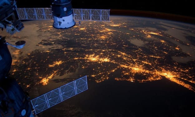
The Power of Satellite Observations
Satellites offer an unparalleled perspective on our planet, enabling the systematic and continuous monitoring of various climate-related parameters. From space, satellites can capture a wealth of information, including atmospheric composition, sea surface temperature, ice cover, land use changes, and greenhouse gas concentrations. These observations provide crucial insights into the state of the Earth's climate system and help scientists discern long-term trends and patterns.
Monitoring Temperature and Weather Patterns
Satellites play a pivotal role in monitoring temperature variations and weather patterns across the globe. Instruments such as the Advanced Microwave Sounding Unit (AMSU) and the Infrared Atmospheric Sounding Interferometer (IASI) detect and measure temperature profiles, humidity levels, and atmospheric moisture content. These observations contribute to weather forecasting, climate modeling, and the identification of climate change-induced shifts in weather patterns.
Assessing Sea Level Rise and Ocean Dynamics
Satellites equipped with altimeters, such as the Jason series, provide critical data on sea level rise and ocean dynamics. These measurements help monitor changes in coastal areas, assess the impact of melting glaciers and ice sheets, and track the movement of ocean currents. Understanding these processes is essential for predicting coastal flooding, coastal erosion, and the implications for ecosystems and human populations.
Tracking Land Use Changes and Deforestation
Satellite imagery enables the monitoring of land use changes, deforestation, and ecosystem degradation. Instruments like the Moderate Resolution Imaging Spectroradiometer (MODIS) capture high-resolution images, allowing scientists to assess deforestation rates, land cover changes, and the extent of wildfires. These observations inform policies and conservation efforts aimed at preserving biodiversity, reducing carbon emissions, and promoting sustainable land management practices.
Mapping and Monitoring Carbon Dioxide Levels
Satellites equipped with sensors, such as the Orbiting Carbon Observatory (OCO-2), provide valuable data on carbon dioxide (CO2) concentrations. These measurements help scientists identify the sources and sinks of CO2, track its global distribution, and monitor changes over time. Understanding CO2 dynamics is crucial for assessing the effectiveness of emission reduction efforts and informing climate change mitigation strategies.
Tracking the Ozone Layer and Atmospheric Composition
Satellites have played a pivotal role in monitoring the Earth's ozone layer, enabling the detection of ozone depletion and the effectiveness of international agreements like the Montreal Protocol. Instruments like the Ozone Monitoring Instrument (OMI) measure ozone concentrations and track the formation and depletion of ozone in the atmosphere. Additionally, satellites provide insights into atmospheric composition, including the presence of greenhouse gases, aerosols, and pollutants, contributing to our understanding of air quality and climate change drivers.
Enhancing Climate Models and Predictions
Satellite data is vital for improving climate models and predictions. The integration of satellite observations into climate models enhances their accuracy and helps validate model outputs. This iterative process of data assimilation and model refinement provides a more comprehensive understanding of climate dynamics and improves our ability to project future climate scenarios.
Supporting Global Climate Change Mitigation Efforts
Satellite observations play a critical role in supporting global climate change mitigation efforts and policy development. They provide objective, verifiable data that underpin international agreements like the Paris Agreement, facilitating the monitoring of countries' greenhouse gas emissions and assessing progress towards emissions reduction targets. Satellite data also aids in identifying areas of afforestation and reforestation, evaluating renewable energy potential, and monitoring the implementation of sustainable development initiatives.
Conclusion
Satellite technology has revolutionized our ability to monitor and understand climate change by providing comprehensive, accurate, and continuous data on various climate indicators. From tracking temperature variations and sea level rise to monitoring deforestation and greenhouse gas concentrations, satellites offer an invaluable vantage point from space. Leveraging this data, scientists and policymakers can make informed decisions, develop effective mitigation strategies, and work towards a sustainable future. As satellite technology continues to evolve, its role in climate change monitoring will only grow, enabling us to address the challenges of climate change with greater precision and urgency.
About the Creator
Tatsuki
Space, Quantitative Finance, Crypto, Blockchain, Langurages, etc.
Personal Blog (Japanese): https://www.jinsei-100nenn.com/
AI Art Project: Space Cat AI (on Instagram)
Follow me:
About Binding Prometheus
I want to start actively advocating on behalf of my own work, and the most valuable part of my canon is, without a doubt, Binding Prometheus, the play I have been working on since 2019 and only finished in 2023 as part of my MA. The play itself is an amalgamation of a million different inspirations. On one end, it evokes the Ancient Greek myth-play, deriving its own title from the earliest extant work of Western drama we have, Aeschylus’s Prometheus Bound. On the other end, it borrows significantly from the sci-fi bulwarks from over the years, namely Mary Shelley’s Frankenstein and Karel Capek’s Rossum’s Universal Robots. The play could be an episode of Black Mirror, I fear. I don’t know. I’ve only ever seen one episode of Black Mirror.
By Steven Christopher McKnight21 days ago in Futurism
Global E-Commerce Market Size and Forecast 2025–2033: A Digital Economy in Hypergrowth
Introduction: The Digital Marketplace Enters a New Era The global e-commerce market has moved far beyond convenience—it is now a central pillar of the modern economy. What began as a niche alternative to brick-and-mortar shopping has evolved into a sophisticated digital ecosystem powered by artificial intelligence, advanced logistics, secure digital payments, and cross-border connectivity. Consumers today expect faster delivery, personalized recommendations, and frictionless payment experiences, and e-commerce platforms are racing to meet those demands.
By Sushant. Renub Researcha day ago in Futurism


Comments
There are no comments for this story
Be the first to respond and start the conversation.