
1.Introduction
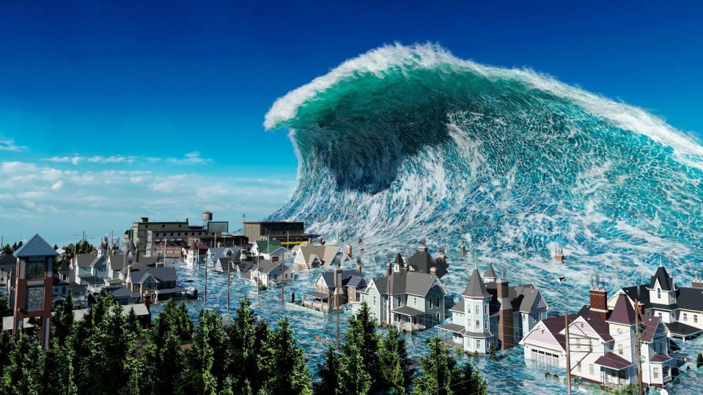
A tsunami is a massive and powerful tidal wave propagating in the sea or oceans caused by a sudden disturbance of the water mass, such as an earthquake, underwater volcanism, meteorite impact and landslides.
Tsunami waves can be over 100 metres high and can travel long distances to shore.
They can occur in a single area or they can have an impact over a larger area, affecting more than one country.Tsunamis can be dangerous because the waves can have a very high speed and can reach high places on land, causing flooding and other problems.
2.How tsunamis form
The most common cause of tsunamis is earthquakes, which cause a sudden disturbance of the seabed. For example, if one tectonic plate collapses beneath another, it can cause a strong earthquake and at the same time raise or lower part of the seabed. This disturbance can cause a shock wave to propagate in all directions, generating a tsunami.
Another type of tsunami can be caused by underwater volcanism, when lava or ash erupts from an underwater volcano and reaches the water, causing a disturbance of the water mass.
In the rare cases when a meteorite or space object falls into the sea, it can also cause a sudden disturbance of the water mass, generating a tsunami.
Tsunamis can be very destructive to affected coastlines. They can destroy towns, villages and other coastal communities, and cause significant loss of life and property damage. Tsunamis can also affect marine life and disrupt aquatic ecosystems.
3.Where most tsunamis form
Tsunamis can occur anywhere in the world, but are more common in the Pacific.Tsunamis are caused by strong earthquakes that occur under the seas or oceans. Earthquakes can be caused by the tectonic movement of the Earth's plates and occur when energy stored inside the Earth is suddenly released.
Tsunamis can be very destructive to affected coastlines. They can destroy towns, villages and other coastal communities, and cause significant loss of life and property damage. Tsunamis can also affect marine life and disrupt aquatic ecosystems.
For example, in December 2004 one of the most devastating tsunamis in history occurred in the Indian Ocean off the coast of Sumatra, Indonesia, which was caused by a magnitude 9.1 earthquake. The tsunami caused massive damage in countries around the Indian Ocean, such as Indonesia, Thailand, Sri Lanka and India, and killed more than 230,000 people.
Another example is the tsunami that hit the coast of Japan in March 2011, causing a nuclear crisis at the Fukushima plant and killing more than 15,000 people.
Other devastating tsunamis have been caused by submarine landslides, such as the 1964 Alaska tsunami, which had a magnitude of 9.2 and killed about 130 people.
4.What people are doing to prevent tsunamis
To protect themselves from tsunamis, people in coastal areas can build protective dykes, which can prevent ocean waves from reaching the shore. There are also tsunami warning systems, which can alert people if a tsunami is detected heading for land. These systems can include sirens, radio and television messages, and mobile phone alerts.
In the event that a tsunami is detected, it is important that people avoid the coastal area and move away from ocean waters as quickly as possible. It is also important to take evacuation measures before the waves reach the shore to avoid suffocation or injury from collapsing structures.
Despite the fact that tsunamis can be devastating, there are still measures that can be taken to protect against them. By building protective dykes and using tsunami warning systems, people can be prepared for these hazards and reduce their negative impact on their lives and property.
5.Interactive webgis services for tsunami early warning system
The article we have been talking about aims to establish early warning systems via WebGIS for the integration, application and dissemination of tsunami risk management data and products.
Studying tsunamis is very important, because this natural disaster generates large-scale coastal inundation and leads to a large number of casualties and major damage.
Due to this natural hazard the Ministry of Earth Sciences,Government of India,has set up the Tsunami Early Warning System,and the INCOIS centre is located in Hyderabad,India where they receive offshore sea level data,bottom pressure recorders and also coastal sea level data from tide gauges.
Main features of WebGIS:
• Adaptive pan and zoom tools on the map
• Map scaling tool
• Displaying the legend of the legend of the legend
• Attribute and metadata information queries
• Measuring distances
• Specific hazard queries combining interdisciplinary datasets
• Query tool that displays all available natural hazard information for a user-specified point or area
• User account for temporary saving of map and user-defined settings
• Map layout and printing
• A context-sensitive help that allows the non-expert user to quickly understand the different functionalities.
WebGIS services are used to publish geospatial information on real-time data, event analysis and DSS results, and tsunami threat information.
6.Conclusions
Although tsunamis are rare events, they can have a devastating impact on people and communities in affected areas. By understanding how tsunamis form and taking the necessary steps to protect themselves from them, people can try to minimise the impact of these destructive natural events.
About the Creator
Keep reading
More stories from Ligia Mițiți and writers in Education and other communities.
Exploring the Enchanting Tapestry of Tourism in Europe
Introduction Europe, a continent steeped in history, culture, and natural beauty, has long been a magnet for travelers seeking diverse experiences. From the romantic streets of Paris to the ancient ruins of Rome, the stunning fjords of Norway to the sun-soaked beaches of Greece, Europe offers an unparalleled tapestry of destinations that cater to a wide range of interests. This article embarks on a journey through the rich and dynamic world of tourism in Europe.
By Ligia Mițiți2 years ago in Education
What Is Dark Energy and Why Is It Accelerating the Universe?
This discovery shocked scientists in the late 1990s and overturned everything we thought we knew about cosmic evolution. Gravity, which should slow expansion, appeared to be losing the battle. Some mysterious force was pushing the universe apart.
By shahkar jalal7 days ago in Education
How Online Shopping Is Transforming Consumer Behavior and Business Models
The last ten years have seen a digital revolution changing the way we think about commerce and consumers, and how we understand and operate within the context of global trade. E-commerce has moved from a market niche to a global pillar of the economy. The ability to purchase a variety of products and services with a single click is no longer a luxury but a requirement for any modern-day consumer. Thanks to technological advances, a population that evolves rapidly each year, and a persistent focus on the user experience when it comes to online shoppers, the e-commerce industry is on the move in 2026.
By Bobby Yadav6 days ago in Education


Comments
There are no comments for this story
Be the first to respond and start the conversation.