

The Aral Sea was an Endorheic lake (a lake that does not flow out, but lowers by evaporation) lying between Kazakhstan to its north and Uzbekistan to its south, which began shrinking in the 1960s and had largely dried up by the 2010s.

In the 1960s, the Soviet Union undertook a major water diversion project on the arid plains of Kazakhstan, Uzbekistan, and Turkmenistan. The region’s two major rivers, fed by snowmelt and precipitation in faraway mountains, were used to transform the desert into farms for cotton and other crops. Before the project, the Syr Darya and the Amu Darya rivers flowed down from the mountains, cut northwest through the Kyzylkum Desert, and finally pooled together in the lowest part of the basin. The lake they made, the Aral Sea, was once the fourth largest in the world.
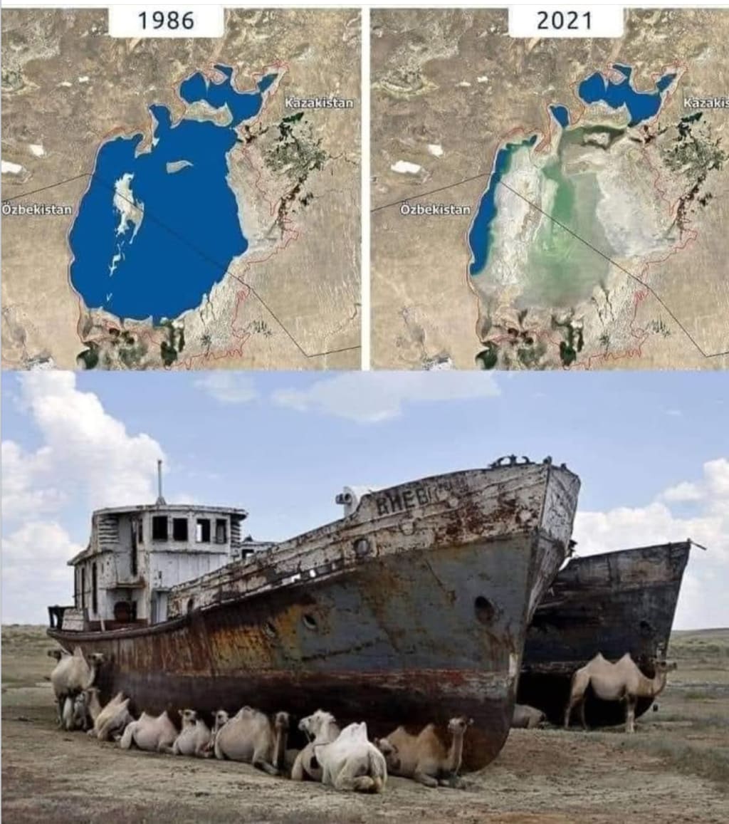
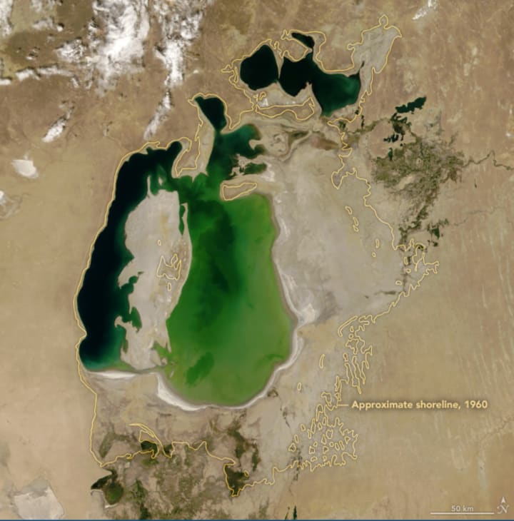
The South Aral Sea had split into eastern and western lobes that remained tenuously connected at both ends. By 2001, the southern connection had been severed, and the shallower eastern part retreated rapidly over the next several years. Especially large retreats in the eastern lobe of the South Aral Sea appear to have occurred between 2005 and 2009, when drought limited and then cut off the flow of the Amu Darya. Water levels then fluctuated annually between 2009 and 2018 in alternately dry and wet years. In 2014, the eastern lobe of the South Aral Sea completely disappeared. Water levels in summer 2018 were not as low as they might have been, following a round of seasonal snowmelt in the spring.
As the Aral Sea has dried up, fisheries and the communities that depended on them collapsed. The increasingly salty water became polluted with fertilizer and pesticides. The blowing dust from the exposed lakebed, contaminated with agricultural chemicals, became a public health hazard. The salty dust blew off the lakebed and settled onto fields, degrading the soil. Croplands had to be flushed with larger and larger volumes of river water. The loss of the moderating influence of such a large body of water made winters colder and summers hotter and drier.

In a last-ditch effort to save some of the lake, Kazakhstan built a dam between the northern and southern parts of the Aral Sea. The Kok-Aral dike and dam, finished in 2005, separates the two water bodies and prevents flow out of the North Aral into the lower-elevation South Aral. The dam has led fisheries in the North Aral to rebound, even as it has limited flow into the South Aral. Between 2005 and 2006, water levels in the North Aral rebounded significantly and very small increases are visible throughout the rest of the time period. The differences in water color are due to changes in sediments and water depth.
By 1989 the Aral Sea had receded to form two separate parts, the “Greater Sea” in the south and the “Lesser Sea” in the north, each of which had a salinity almost triple that of the sea in the 1950s. By 1992 the total area of the two parts of the Aral Sea had been reduced to approximately 13,000 square miles (33,800 square km), and the mean surface level had dropped by about 50 feet (15 metres). The governments of the states surrounding the Aral Sea tried to institute policies to encourage less water-intensive agricultural practices in the regions south and east of the lake, thus freeing more of the waters of the Amu Darya and the Syr Darya to flow into the lake and to stabilize its water level. Those policies succeeded in reducing water usage somewhat but not to the level necessary to have a significant impact on the amount of water reaching the Aral Sea. In 1994 those same states—Kazakhstan, Turkmenistan, and Uzbekistan, with the addition of Kyrgyzstan and Tajikistan—established a joint committee to coordinate efforts to save the Aral Sea. The difficulty of coordinating any plan between those competing states, however, hampered progress.
By the end of the century the Aral Sea had receded into three separate lakes: the Greater Sea had divided into a long, narrow, western lake and a larger, broader, eastern lake, with the remains of the Lesser Sea to the north. The water level had dropped to 125 feet (36 metres) above sea level, and the water volume was reduced by three-fourths of what it had been in 1960. Almost no water from the Amu Darya and the Syr Darya ever reached the Aral Sea anymore. In the early 21st century the eastern portion of the Aral Sea suffered the most drastic and immediate decline—diminishing by some four-fifths between 2006 and 2009. The World Bank funded the construction of the Kok-Aral Dam (completed 2005) and projects along the Syr Darya that appeared to be preserving the northern portion of the sea. However, the southern portion—both the eastern and western lobes but most notably the eastern—continued to shrink, despite some inflow of water from the north. For periods of time after 2010, the eastern lobe dried up altogether.
The rapid shrinkage of the Aral Sea led to numerous environmental problems in the region. By the late 1980s the lake had lost more than half the volume of its pre-1960 water. The salt and mineral content of the lake rose drastically because of that, making the water unfit for drinking purposes and killing off the once-abundant supplies of sturgeon, carp, barbel, roach, and other fishes in the lake. The fishing industry along the Aral Sea was thus virtually destroyed. The ports of Aral in the northeast and Mŭynoq in the south were now far from the lake’s shore. A partial depopulation of the areas along the lake’s former shoreline ensued. The contraction of the Aral Sea also made the local climate noticeably harsher, with more-extreme winter and summer temperatures.

In the late 1990s an island in the Aral Sea, Vozrozhdenya, became the centre of environmental concern. The Aral Sea derived its name from the Kyrgyz word Aral-denghiz, “Sea of Islands”—an apt designation, as there were more than 1,000 islands of a size of 2.5 acres (1 hectare) or more strewn across its waters. Many of those islands subsequently became joined to the mainland with the shrinking size of the sea. By the early 21st century the sea had receded to a level where Vozrozhdenya Island had become a peninsula of the mainland. The increasing accessibility of the island from the mainland was of special concern because Vozrozhdenya had been a secret testing ground for Soviet biological weapons during the Cold War. In addition to experiments done there on such agents as tularemia and bubonic plague, hundreds of tons of live anthrax bacteria were buried on the island in the 1980s. In 1999 still-living anthrax spores were discovered on the site, and in 2002 a team of workers from the United States cleaned up the burial sites.
The health costs to people living in the area began to emerge soon after water levels had dropped enough to uncover portions of the seabed. Hardest hit were the Karakalpaks, who live in the southern portion of the region. Winds blowing across the exposed seabed produced dust storms that buffeted the region with a toxic dust contaminated with salt, fertilizer, and pesticides. As a result, the areas’s inhabitants have suffered health problems at unusually high rates—from throat cancers to anemia and kidney diseases—and infant mortality in the region has been among the highest in the world.
The ripple effect caused by the unforeseen effects of man made manipulations has been severe, to the earth and to the people living in the area.
About the Creator
Guy lynn
born and raised in Southern Rhodesia, a British colony in Southern CentralAfrica.I lived in South Africa during the 1970’s, on the south coast,Natal .Emigrated to the U.S.A. In 1980, specifically The San Francisco Bay Area, California.
Man (22) Charged With Murder of English Tourist in Temple Bar
Arrest and Formal Charges A 22-year-old man has been charged with the murder of an English tourist following a fatal incident in Dublin’s Temple Bar area. The charge comes after an intensive Garda investigation into events that unfolded in one of Ireland’s busiest and most popular nightlife districts.
By Aarif Lashari3 days ago in Earth
Flower Bloom 369
FLOWER Bloom 2/25/26 Wednesday By Mariann Carroll Karen had been with Tony for 7 years. Tony started acting strangely after her surgery. He would mow the lawn in the rain and be on his cellphone. He started pushing Karen away. Tony came clean about seeing someone. Karen moved out two months later. Karen moved in with a friend. She felt betrayed.
By Mariann Carroll4 days ago in Fiction


Comments
There are no comments for this story
Be the first to respond and start the conversation.