
Storm Goretti Brings Snow and Rain to Southern Ireland
Status Yellow warnings are in effect as the first named storm of the season moves across the country, impacting travel and local conditions.

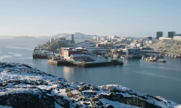
Warnings Issued for Southern Counties
Met Éireann has issued Status Yellow snow and rain warnings for several counties as Storm Goretti moves across southern Ireland. The warnings are in place for Carlow, Kildare, Kilkenny, Laois, Wexford, Wicklow, and Waterford. The national forecaster states that rain will turn to sleet and snow in these areas, particularly on higher ground. A separate rain warning is active for Cork and Waterford, where heavy rainfall is expected.
This weather event is the first named storm to impact Ireland this season. The decision to name the storm was made by the UK Met Office, which coordinates with Met Éireann as part of the Western Europe storm naming group. The naming aims to improve public awareness and preparedness for significant weather events. The warnings are scheduled to last through the afternoon and evening hours.
Expected Precipitation and Accumulation
Forecast models indicate that the most significant snow accumulations will be confined to higher elevations. Areas above 200 meters are likely to see slushy accumulations of 1 to 3 centimeters. At lower levels, precipitation will mostly fall as cold rain or a wintry mix of sleet and rain. The change from rain to snow is driven by a drop in atmospheric temperature as the storm system passes.
The heavy rainfall in coastal southern counties, like Cork, presents a separate set of concerns. Localized spot flooding is possible in areas with poor drainage. The combination of melting snow at higher elevations and ongoing rain could lead to increased water levels in small streams and rivers. The shift to snow is expected to be temporary, with a return to rain forecast as slightly less cold air moves in later.
Immediate Travel Disruption and Advice
The primary impact of Storm Goretti is on road travel. The wintry mix creates hazardous driving conditions. Icy patches are likely to form on untreated roads, especially on secondary routes and higher passes. Motorists are advised to exercise extreme caution, reduce speed, and increase braking distance. The RSA advises checking local traffic and weather conditions before any essential journey.
Public transport services may also experience delays. Bus Éireann and Irish Rail are operating as normal but have warned customers to expect possible schedule changes due to weather conditions. Travelers should check for service updates directly from transport providers. At Dublin Airport, operations are currently normal, but passengers are advised to monitor their flight status with their airline.
Risks to Livestock and Farming Community
The arrival of wintry weather presents challenges for the farming sector. Sudden snow and cold can be difficult for livestock, particularly for newborn lambs in early-season flocks. Farmers are being urged to ensure animals have adequate shelter and access to unfrozen water. Moving livestock to lower, more sheltered fields is recommended where possible.
The wet conditions also make ground conditions poor for machinery. Any planned spreading of fertilizer or other field work will likely be delayed until the ground dries out. The Department of Agriculture has circulated advisories to farming organizations, emphasizing animal welfare and farm safety during the sudden cold snap.
Comparison to Recent Weather Patterns
Storm Goretti arrives after a period of relatively mild and unsettled weather dominated by Atlantic low-pressure systems. This storm is different because it is pulling down colder air from the north as it moves across the country. This interaction between the moist storm system and the colder air mass is what creates the snow potential, rather than the storm's inherent strength.
It is not uncommon for Ireland to experience such wintry spells in late January and February. While the accumulations forecast are not extreme, they are significant enough to cause disruption due to the country's limited infrastructure for dealing with snow and ice. The event is a reminder that winter conditions can occur even during a season that has been largely mild.
Public Safety and Preparedness Steps
Local authorities have activated their winter maintenance plans in response to the warnings. County councils in the affected areas are gritting primary and secondary roads. The public is advised to stay updated through official channels like the Met Éireann website and app. It is also recommended to check in on elderly or vulnerable neighbors who may be affected by the cold.
Households should take basic precautions. This includes ensuring heating systems are working, having torches available in case of local power interruptions, and avoiding unnecessary travel during the peak of the warning period. Small amounts of snow and ice can lead to slips and falls, so care is needed when walking on footpaths and driveways.
Broader Weather Context Across the Region
The storm system affecting Ireland is part of a broader pattern across Western Europe. The UK Met Office has also issued weather warnings for parts of Wales and southwest England, where similar conditions of rain turning to snow are expected. The movement of Storm Goretti is being tracked closely by both national forecasting services.
After the storm passes, the weather is expected to remain unsettled. The current forecast suggests a return to more typical Atlantic-driven weather with bands of rain and strong winds moving across Ireland. However, nighttime temperatures may remain near or below freezing in many areas, leading to ongoing risks of ice in the mornings following wet weather.
Economic and Local Business Impact
The immediate economic impact is likely to be minor but noticeable. Retail footfall in town centers may be lower due to travel warnings. Conversely, local grocery stores may see an increase in shoppers preparing for the short-term disruption. For the hospitality sector, cancellations for Tuesday evening are possible, particularly in areas under the snow warning.
Outdoor construction and service industry work will be paused in the hardest-hit counties. The overall economic cost will depend on the duration and severity of the conditions. Short, sharp weather events like this typically result in a temporary dip in productivity rather than sustained economic damage.
Role of Modern Forecasting Technology
The accurate prediction of this snow event demonstrates advances in weather modeling. High-resolution models allowed forecasters to pinpoint which counties would see the transition from rain to snow. This precision enables more targeted warnings, helping the public and authorities prepare more effectively without causing unnecessary alarm.
Met Éireann’s warning system is tiered to reflect the level of threat. A Status Yellow warning, as issued for Storm Goretti, advises the public to be aware of potentially hazardous conditions and to consider altering plans. This is a step below Status Orange (prepare) and Status Red (take action). The system is designed to provide clear, actionable information.
Post-Storm Assessment and Cleanup
Once the warnings expire, the focus will shift to cleanup and assessment. Local councils will assess any minor damage, such as fallen branches caused by the weight of wet snow. Road crews will continue gritting operations into the night to manage refreezing as temperatures drop. Utility companies will be on standby, though widespread power outages are not anticipated with this storm.
The event will also be reviewed by Met Éireann as part of its standard procedures. Data collected on snowfall amounts and impacts will be used to refine future forecasts and warnings. Public feedback on the clarity and usefulness of the warnings may also be solicited to improve communication for future weather events.
Looking Ahead to the Rest of the Week
The passage of Storm Goretti does not signal the start of a prolonged cold spell. Forecasts indicate that the weather will gradually become milder later in the week, with temperatures returning to average for this time of year. However, the pattern remains active, with further bouts of rain and wind expected from the Atlantic.
The public is encouraged to view this weather event as a routine winter occurrence. Staying informed through reliable sources and taking sensible precautions are the most effective ways to manage the minor disruption caused. The system is expected to clear into the Irish Sea by Wednesday morning, leaving a cold but clearer day behind.
About the Creator
Saad
I’m Saad. I’m a passionate writer who loves exploring trending news topics, sharing insights, and keeping readers updated on what’s happening around the world.
Britain in Talks With NATO to Boost Arctic Security
The Arctic Is No Longer a Frozen Backwater For decades, the Arctic sat quietly on the margins of global politics—remote, frozen, and largely ignored. That era is over. Britain is now in talks with NATO to strengthen Arctic security, acknowledging growing risks posed by Russia and China. In a notable shift, London’s assessment aligns closely with warnings long emphasized by Donald Trump, particularly as he continues to express strategic interest in Greenland. What once sounded like an eccentric fixation has evolved into a serious geopolitical conversation. The Arctic is rapidly becoming one of the world’s most contested regions, and Britain is positioning itself to play a larger role. Why Britain Is Paying Attention Now Although the UK is not an Arctic nation, it is an Arctic-adjacent power with significant strategic interests. British officials increasingly view the High North as critical to national and allied security. Melting ice is opening new shipping routes, exposing untapped natural resources, and making military movement easier than ever before. Britain’s talks with NATO focus on intelligence sharing, joint exercises, surveillance capabilities, and protecting undersea infrastructure such as communication cables and energy pipelines. These are not abstract concerns. Any disruption in the Arctic could have immediate consequences for European security and global trade. In short, what happens in the Arctic does not stay in the Arctic. Russia’s Expanding Arctic Footprint Russia is the dominant military power in the Arctic, and it is not slowing down. Moscow has reopened Soviet-era bases, deployed advanced missile systems, expanded its icebreaker fleet, and increased patrols across the region. The Arctic coastline represents a core part of Russia’s nuclear deterrent, making it strategically vital to the Kremlin. From NATO’s perspective, this military buildup creates both risk and uncertainty. Britain, which has long been vocal about Russian aggression—from Ukraine to cyber warfare—sees the Arctic as another front where deterrence must be strengthened before tensions spiral. The concern is not necessarily an immediate conflict, but miscalculation. In a region with harsh conditions and limited communication infrastructure, even minor incidents could escalate rapidly. China’s Quiet but Steady Arctic Ambitions While Russia’s presence is overt, China’s Arctic strategy is more subtle—and equally concerning to Western planners. Beijing calls itself a “near-Arctic state,” a label that has raised eyebrows in Europe and North America. Through investments, research stations, and partnerships, China is laying the groundwork for long-term influence. Britain shares NATO’s concern that China could use civilian projects for dual-use purposes, blending scientific research with intelligence gathering and infrastructure control. As Arctic shipping routes become commercially viable, China’s interest in controlling parts of the supply chain only grows. London’s alignment with these concerns reflects a broader shift in UK foreign policy: China is no longer viewed solely as an economic partner, but as a strategic competitor. Trump, Greenland, and Strategic Reality Donald Trump’s repeated interest in Greenland—most famously his suggestion that the United States should buy it—was widely mocked at the time. Yet behind the headlines was a strategic logic that many Western governments now openly acknowledge. Greenland sits at the heart of the Arctic, hosting vital air and naval routes between North America and Europe. It is also rich in rare earth minerals critical for modern technology and defense systems. As ice recedes, Greenland’s strategic value only increases. Britain’s current position, which aligns with Trump’s warnings about Arctic vulnerabilities, shows how quickly political perceptions can change. What once seemed unconventional now appears prescient. NATO’s Arctic Awakening NATO has traditionally focused on Eastern Europe and the North Atlantic. The Arctic, despite its importance, received less coordinated attention. That is changing. Britain’s talks with NATO reflect a broader alliance effort to integrate Arctic defense into its core strategy. This includes: Increased joint military exercises in cold-weather environments Enhanced monitoring of Russian and Chinese activity Strengthening cooperation with Arctic nations like Norway, Canada, and Denmark Protecting critical undersea and satellite infrastructure For Britain, this is also about credibility. As a leading NATO member and a key military power, the UK wants to demonstrate that it can contribute meaningfully beyond its immediate geography. Climate Change as a Security Multiplier One of the most striking aspects of Arctic security is how closely it is tied to climate change. Melting ice is not just an environmental issue—it is a strategic one. New sea lanes shorten travel between Asia and Europe, while access to oil, gas, and minerals becomes easier. This transformation increases competition and reduces natural barriers that once limited military movement. Britain’s involvement reflects recognition that climate-driven changes are reshaping the security landscape faster than traditional institutions were designed to handle. In this sense, Arctic security is a preview of future global challenges where environmental change and geopolitics collide. Domestic and Diplomatic Balancing Acts Britain’s Arctic engagement is not without challenges. Increased military involvement raises questions about defense spending, priorities, and escalation risks. Diplomatically, London must balance deterrence with dialogue, avoiding actions that could unnecessarily provoke Russia while still protecting allied interests. There is also the question of public awareness. Arctic security lacks the visibility of conflicts like Ukraine, making it harder to sustain political attention. Yet policymakers increasingly argue that prevention is cheaper—and safer—than crisis response. What This Means Going Forward Britain’s talks with NATO mark an important shift in how the Arctic is viewed: not as a distant frontier, but as a central arena in 21st-century security. Agreement with Trump-era assessments on Russia, China, and Greenland underscores how geopolitical realities can outlast political controversies. As competition intensifies, the Arctic will likely become a testing ground for cooperation, deterrence, and strategic foresight. Britain’s involvement signals that mid-sized powers are no longer content to watch from the sidelines. Final Thoughts The Arctic is warming faster than any other region on Earth—and so are the geopolitical tensions surrounding it. Britain’s move to boost Arctic security with NATO reflects a growing consensus that ignoring the High North is no longer an option. Whether driven by Russia’s militarization, China’s quiet expansion, or lessons drawn from Trump’s blunt warnings, one truth stands out: the future of global security may well be shaped at the top of the world, where ice, ambition, and power now intersect.
By Muhammad Hassan7 days ago in Earth


Comments
There are no comments for this story
Be the first to respond and start the conversation.