
Polar Vortex Collapse Forecast
What This Atmospheric Shift Could Mean for Winter Weather Around the World

Every winter, the polar vortex quietly controls much of the weather across the Northern Hemisphere. Most people only hear about it when extreme cold suddenly sweeps into places like North America or Europe. Recently, scientists and meteorologists have begun forecasting conditions that suggest a possible polar vortex collapse, a major atmospheric disruption that could lead to unusual and prolonged winter weather.
While the term sounds alarming, it doesn’t mean disaster is guaranteed. Instead, it signals a shift in how cold Arctic air moves around the planet. Understanding what this forecast means can help us prepare for what may come next.
What Is the Polar Vortex?
The polar vortex is a massive area of low pressure and cold air that circles the Arctic high in the atmosphere. It forms every winter when the polar region cools rapidly and strengthens strong winds that trap freezing air near the North Pole.
Under normal conditions, the vortex acts like a wall, keeping the cold locked in the Arctic. This allows mid-latitude regions, such as the United States, Europe, and parts of Asia, to experience more balanced winter temperatures.
However, when the polar vortex weakens or becomes unstable, that barrier breaks down. Cold air can then travel south, causing sudden and intense cold spells far from the Arctic.
What Does “Polar Vortex Collapse” Mean?
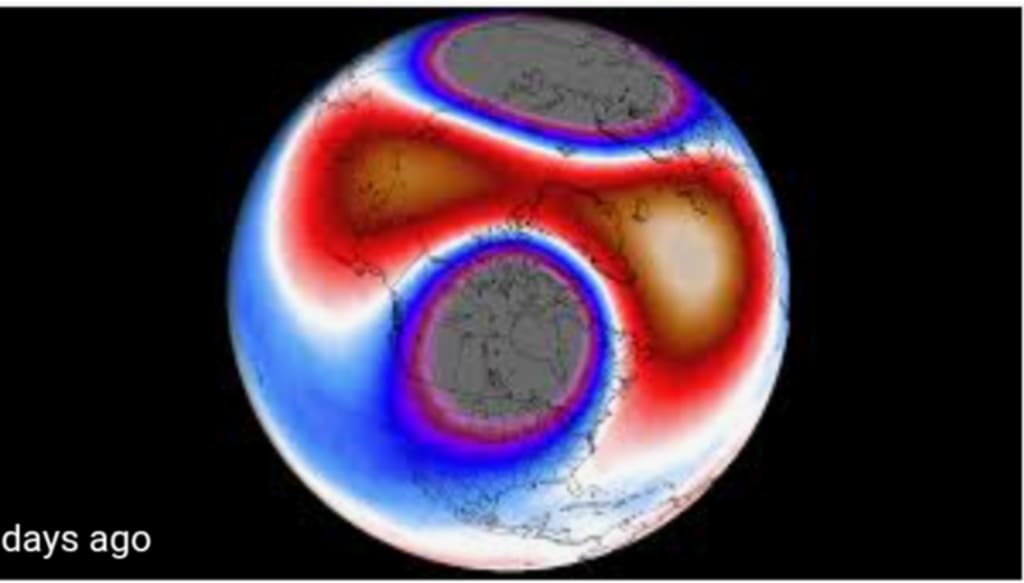
A polar vortex collapse does not mean the system disappears entirely. Instead, it refers to a major weakening or breakdown of its structure. This usually occurs during an event called Sudden Stratospheric Warming (SSW).
During an SSW, temperatures in the upper atmosphere rise dramatically in just a few days. This warming disrupts the powerful winds that normally keep the polar vortex stable. As a result, the vortex can split into separate pieces or shift away from the pole.
When this happens, cold Arctic air becomes free to move southward, influencing weather patterns for weeks rather than days.
What Are Forecast Models Indicating?
Recent atmospheric models show signs that conditions are aligning for a possible polar vortex disruption. These models track changes in temperature, pressure, and wind patterns high in the stratosphere and detect anomalies that often appear before a collapse.
Key indicators include:
Rising temperatures in the stratosphere
Weakening polar winds
Changes in jet stream behavior
Pressure shifts resembling past vortex breakdown events
If these trends continue, the effects could be felt well into late winter or even early spring.
How Could This Affect Weather?
A polar vortex collapse can reshape weather patterns across much of the Northern Hemisphere. The most common impacts include:
1. Extended Cold Spells
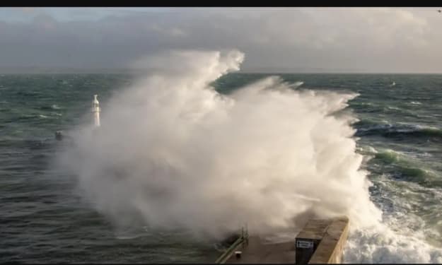
Cold Arctic air may surge into mid-latitude regions such as North America and Europe. Unlike normal cold fronts that pass in a few days, these outbreaks can linger for weeks, keeping temperatures well below seasonal averages.
2. Heavy Snow and Ice Storms
When cold air meets moisture from storm systems, the result can be intense snowfall or ice storms. Areas not used to severe winter weather may face travel disruptions and infrastructure challenges.
3. Unstable and Erratic Weather
The jet stream becomes more wavy and unpredictable during a vortex collapse. This can cause rapid changes between warm and cold conditions, sometimes referred to as “weather whiplash.”
4. Economic and Social Effects
The impacts go beyond temperature. Energy demand rises as people use more heating. Transportation systems may be disrupted by snow and ice. Health risks also increase, especially for elderly populations and those without adequate shelter.
Why Is This Happening More Often?
Scientists believe Arctic warming plays a role in weakening the polar vortex. The Arctic is heating up faster than the rest of the planet, reducing the temperature difference between the pole and mid-latitudes. This difference normally helps keep the vortex strong and stable.
With a weaker temperature gradient, the vortex becomes more vulnerable to disruption, increasing the likelihood of extreme cold events in regions far from the Arctic.
Why This Forecast Matters
A polar vortex collapse forecast is not a prediction of disaster, but it is a warning signal. It allows governments, energy providers, and communities to prepare for possible prolonged winter conditions.
Preparation may include:
Ensuring power grids can handle higher demand
Stocking emergency supplies
Issuing early weather alerts
Protecting vulnerable populations
The earlier such events are identified, the better the chances of reducing their impact.
Looking Ahead
The polar vortex reminds us that Earth’s atmosphere is deeply interconnected. Changes that occur miles above the surface can shape the weather we experience on the ground weeks later.
Whether this forecast leads to severe cold or only mild disruption, it highlights the importance of monitoring atmospheric systems and understanding how climate patterns are evolving. In a world where weather extremes are becoming more common, staying informed and prepared is essential.
Winter may be unpredictable, but knowledge remains one of our strongest tools against uncertainty.
About the Creator
Sajida Sikandar
Hi, I’m Sajida Sikandar, a passionate blogger with 3 years of experience in crafting engaging and insightful content. Join me as I share my thoughts, stories, and ideas on a variety of topics that matter to you.
Keep reading
More stories from Sajida Sikandar and writers in Earth and other communities.
Huge Landslide Leaves Sicilian Homes Teetering on Cliff Edge
A massive landslide in Sicily has left dozens of homes perched dangerously on the edge of a collapsing cliff, forcing evacuations and raising urgent concerns about safety, climate resilience, and long-term urban planning. The dramatic incident unfolded after days of heavy rainfall weakened the soil beneath a coastal residential area, causing large sections of land to slide away into the sea.
By Sajida Sikandar3 days ago in Earth
Franklin County Snow Emergency
Winter weather in Ohio can change quickly, and when heavy snow or ice hits, local governments rely on snow emergency levels to keep residents safe. One of the most searched winter questions each year is: what level is Franklin County snow emergency right now? Understanding how these emergency levels work—and how they compare with nearby counties like Delaware County—can help drivers, workers, and families make safer decisions during severe weather. This article breaks down everything you need to know about the Franklin County snow emergency, including how levels are determined, where to find updates, and what each level means for daily life. What Is a Snow Emergency in Franklin County? A snow emergency is declared when weather conditions make travel dangerous due to snow, ice, or freezing rain. In Franklin County, Ohio, officials monitor road conditions, weather forecasts, and accident reports before announcing a snow emergency level. The Franklin County snow level system is designed to limit unnecessary travel and reduce accidents. Each level comes with specific guidelines for residents and employers. Local media outlets, especially 10TV Weather, play a major role in communicating these updates to the public in real time. Snow Emergency Levels Explained To understand what level snow emergency is Franklin County Ohio, it helps to know what each level represents. Level 1 Snow Emergency A Level 1 advisory means roads are slippery, especially bridges and secondary roads. Drivers should use caution, reduce speed, and allow extra stopping distance. Travel is permitted No legal restrictions Increased risk on untreated roads At this stage, daily activities usually continue as normal, though delays are common. Level 2 Snow Emergency When conditions worsen, officials may declare a Level 2 snow emergency. This signals that roads are hazardous and travel should be limited to essential trips only. Driving is discouraged Only necessary travel is advised Accidents become more frequent During a Level 2, many schools, businesses, and government offices may close or operate on delays. This is often the level that sparks widespread concern across Franklin County. Level 3 Snow Emergency Level 3 is the most serious designation. Roads are extremely dangerous or impassable, and travel is legally restricted. Only emergency personnel should be on the roads Driving can result in citations or arrest Conditions pose serious safety risks A Level 3 snow emergency is rare but critical. When declared, residents are urged to stay indoors until conditions improve. How Franklin County Determines Snow Emergency Levels Officials rely on multiple factors before announcing a snow emergency: Snowfall totals and accumulation rates Ice formation and road treatment effectiveness Traffic accidents and emergency response delays Weather forecasts from meteorologists Agencies coordinate closely with weather services and local law enforcement. Reports from 10TV Weather often provide early insight into whether conditions may escalate. Comparing Franklin County and Delaware County Snow Emergencies Many Ohio residents commute between counties, which makes comparing alerts important. A Delaware County snow emergency may not always match Franklin County’s status. For example: Franklin County could be under a Level 2 while Delaware County remains at Level 1 Snow bands may impact northern counties more severely Timing of road treatment can differ Drivers should always check both counties before traveling. Conditions can change rapidly, especially during overnight storms. Where to Find Reliable Updates Staying informed is essential during winter storms. The most reliable sources for Franklin County snow emergency updates include: Franklin County Sheriff’s Office announcements Official county websites and social media pages Local news stations, especially 10TV Weather Emergency alert systems and local radio Searching phrases like what level is Franklin County or what level snow emergency is Franklin County Ohio during storms is common, but always rely on official sources for confirmation. How Snow Emergencies Affect Schools and Workplaces Snow emergency levels often influence closures and delays: Schools typically close at Level 2 or Level 3 Government offices may shut down during Level 2 Many employers follow county advisories However, private businesses may set their own policies, so employees should check with supervisors directly. Preparing for a Franklin County Snow Emergency Preparation can make a major difference during winter weather. Residents are encouraged to: Keep vehicles fueled and stocked with emergency supplies Monitor forecasts before storms arrive Avoid unnecessary travel during Level 2 or Level 3 emergencies Check on elderly neighbors when conditions worsen Simple planning can reduce stress and improve safety during severe winter events. Why Snow Emergency Levels Matter Snow emergencies are not just warnings—they are safety tools. Each Franklin County snow level helps emergency crews prioritize resources, reduce accidents, and protect lives. Ignoring advisories can put drivers and first responders at risk. Understanding the system allows residents to make informed, responsible decisions. Final Thoughts Winter in Ohio is unpredictable, but information makes it manageable. Knowing how the Franklin County snow emergency system works—and staying updated through trusted sources like 10TV Weather—can help you stay safe when conditions deteriorate. Whether you’re checking what level is Franklin County, comparing alerts with a Delaware County snow emergency, or planning your commute, awareness is your best defense against winter hazards.
By Saboor Brohi 6 days ago in Earth
One Hard Thing
Stop me if you’ve heard this one before: You have the number, you know your schedule- you’ve even picked out the perfect day and time to make this appointment. Shoot, you’ve even picked out alternative days and times just in case their schedules can’t accommodate you!
By Taylor Rigsby6 days ago in Motivation


Comments
There are no comments for this story
Be the first to respond and start the conversation.