
Planet Science Research Issue 5: China's second largest saltwater lake, why did it suddenly disappear?
Second largest saltwater lake disappears

Many people know that China's first inland lake is also China's first saltwater lake Qinghai Lake, then the second largest saltwater lake is where? Lop Nor is China's once the second largest saltwater lake (now the second largest saltwater lake is Namucuo), also known as Lop Nur. Lop Nor is located in the eastern end of the Tarim Basin in Xinjiang, the most low-lying Lop Nor lowlands, the system of tectonic trap lake, formed in the early Quaternary period. Ancient period its main source from the Tarim River, also endured from the east of the Shule River confluence of people from the Qilian Mountains, Arjinshan vein part of the ice and snow melt water, can be described as left and right, so once the Lop Nur Lake area is huge. ↓
China's ancient texts have records of Lop Nor, such as the "Book of Han - the Western Region," recorded "Pu Changhai saltwater also, a wide area of 300 miles, its water stops living, winter and summer do not increase or decrease. From the above, it can be seen that until the Han Dynasty, Lop Nor is still a lake is abundant, vast, and developed agriculture and animal husbandry. At that time, one of the 36 countries in the western region of Loulan is located in the west of the lake, where was a famous trading post on the "Silk Road". By the end of the Eastern Han Dynasty, the Three Kingdoms period, and the establishment of the Western Region, the administrative center is located in the northwest of Lobos. ↓
East of the snow-capped mountains, west of the Yangtze River, the existence of thousands of years of Lop Nor Lake, actually in the 1970-1972 years suddenly disappeared, this is why? This is inseparable from the natural resources and human activities that Lop Nor has.
From the point of view of natural resources, on the surface, the location of Lop Nor is extremely advantageous - east of the Shule River, west of the Tarim River, but a hidden mystery. The Tarim River and the Shule River are both inland rivers. Although the Tarim River, with a total length of 1,321km, was once the largest inland river in China, the Tarim River is a typical inland river with seasonal breaks in arid areas.
↑ It can be seen that the middle section of the Tarim River today has a very low runoff volume despite its wide riverbed.
In the last 40 years or so, the main stem of the Tarim River has experienced a break in the flow, especially in the last 30 years, the location of the Tarim River break has moved up from the Chara section in the lower reaches to the Imbaza in the middle reaches and even the Xinquman section in the upper reaches, with the break moving up about 770km.
The main reason for the breakage of the Tarim River is the decrease of water from the upper reaches. From the viewpoint of the water flowing into the mainstream Tarim River, the water flowing into the Tarim River from the three sources of Aksu River, Hotan River, and Yarkant River was about 6.1 billion m3 in the 1950s and 1960s, but by the end of 1990s, it was reduced to 4.4 billion m3, a decrease of 1.7 billion m3 in 40 years, at an average rate of 42.5 million m3 per year. At the same time, the water consumption in the middle and upper reaches of the mainstream of the Tarim River has been increasing, resulting in the decreasing amount of water reaching the downstream Chara section. This has caused the Tarim River to become a seasonal river since the 1990s.
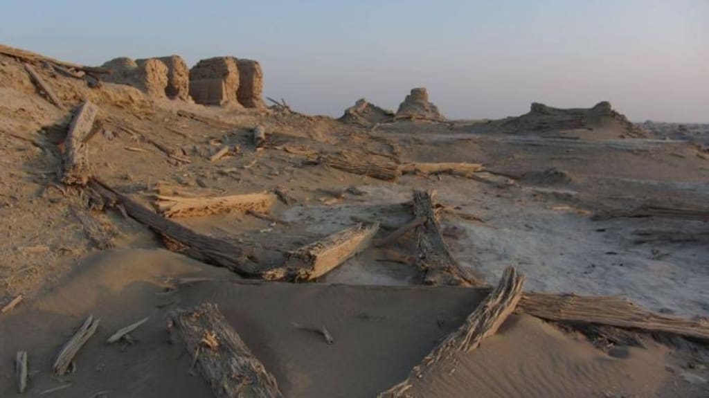
Adding to the fact that Lop Nor is in the eastern part of the Taklamakan Desert, the climate and its dryness have caused a great decrease in the water volume of the lake, the water surface contracted and shifted westward, and a large area of the lake bottom was exposed, which eventually became a vast area of saline flats and marshlands. In 1950, when the Soviet Zeprenkov visited the lake, only some small and shallow ponds were seen near the lakeshore, and Lop Nor had completely dried up and disappeared, leaving only a large salt marsh.
↑In 1952, the Tarim River returned to its original course, and Lop Nor came back to life. 1958 August, the Tianshan rivers flooded at the same time, making Lop Nor expand in the area. But not long after, because of the dry climate, evaporation is strong, Lop Nor water is not enough, the lake shrinks, and finally dried up completely around 1964 and become salt flats, leaving more than 20 semi-circular ancient shore embankments, resembling a huge ear wheel.
↑Between 2000 and 2010, the Tarim River Basin has implemented 11 ecological water transfers, with a total of 2.66 billion m3 of water released from the Daxihaizi Reservoir to the lower reaches of the Tar River, and 8 times to This has ended the history of nearly 30 years of continuous disconnection of the Tarim River downstream, and effectively improved the ecological environment downstream. However, this could not restore the lost Lop Nor, because the restored Tarim River was diverted again, and the downstream section was changed from the direction of Lop Nor to the direction of Ruoqiang County, causing a big regret.
About the Creator
Zeev Lo Va
Who to idle away one's time, youth will fade, life will abandon them。
Keep reading
More stories from Zeev Lo Va and writers in Earth and other communities.
28 billion light years! Hubble discovers the most distant star in the universe, whose light took 12.9 billion years to reach Earth
The Hubble Space Telescope has made an important discovery, according to a new study published in the journal Nature [1]. It has observed the most distant known star, currently 28 billion light-years from Earth. The light from this star took 12.9 billion years to reach Earth.
By Zeev Lo Va3 years ago in Earth
The Universe That Dreams Us
For centuries, humanity believed the universe was expanding. Galaxies drifting farther apart. Space stretching endlessly like an invisible fabric. The theory had been supported by decades of observations, especially from the famous Hubble Space Telescope, which showed distant galaxies moving away from Earth in every direction.
By Abubakar2207 days ago in Earth


Comments
There are no comments for this story
Be the first to respond and start the conversation.