
“Bomb Cyclone” Brings Blizzards to Midwest as Storm Turns to East Coast
Maps Show Latest Forecast as Millions Brace for Severe Winter Weather
A powerful “bomb cyclone” is sweeping across the United States, delivering blizzard conditions to the Midwest before intensifying and shifting toward the East Coast. The rapidly strengthening winter storm has already disrupted travel, caused power outages, and prompted emergency warnings, with meteorologists cautioning that the worst impacts may still be ahead for parts of the Northeast.
The term bomb cyclone refers to a storm that rapidly intensifies when atmospheric pressure drops dramatically within a 24-hour period. This explosive development fuels extreme weather, including heavy snowfall, hurricane-force wind gusts, and dangerously cold temperatures. According to meteorologists, this particular system meets all the criteria, making it one of the most impactful winter storms of the season.
Midwest Hit With Blizzard
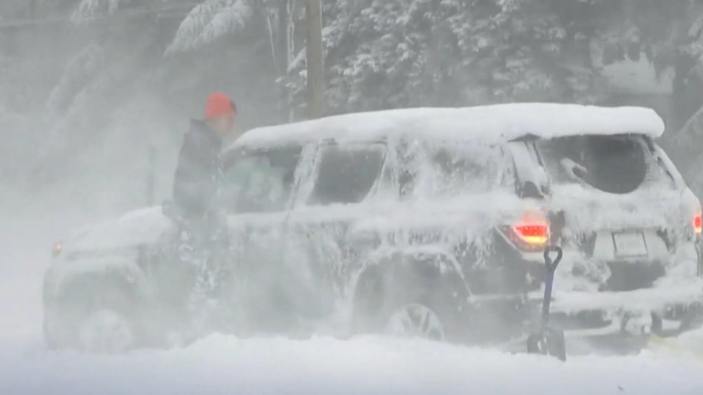
The storm first slammed into the Midwest, where states such as Minnesota, Wisconsin, Iowa, and Michigan experienced whiteout conditions. Heavy snow combined with strong winds significantly reduced visibility, prompting blizzard warnings and forcing authorities to close major highways.
Snowfall totals in some areas exceeded a foot, while wind gusts reached speeds capable of creating life-threatening wind chills. In rural regions, drifting snow made roads impassable, leaving some communities temporarily isolated. Emergency crews urged residents to stay indoors unless travel was absolutely necessary.
Air travel was also heavily affected. Hundreds of flights were delayed or canceled at major Midwestern airports as runways became snow-covered and de-icing operations struggled to keep pace with the storm’s intensity.
Rapid Intensification: Why This Storm Is So Dangerous
What makes a bomb cyclone particularly hazardous is the speed at which it strengthens. As cold Arctic air collides with warmer, moist air from the south, the storm rapidly gains energy. This sharp pressure drop creates powerful winds that worsen snowfall impacts and increase the risk of power outages.
Meteorologists noted that this storm’s pressure drop occurred faster than average, leading to more severe conditions than initially forecast. The result has been a volatile mix of heavy snow, ice in some regions, and bitterly cold air following behind the system.
Experts warn that these storms can be deceptive. Conditions may appear manageable at first, only to deteriorate rapidly within hours.
Storm Shifts Toward the East Coast
As the bomb cyclone moves eastward, its impacts are evolving. While snowfall intensity may lessen for some inland areas, the storm is expected to bring strong winds, coastal flooding, and a mix of snow and rain to parts of the East Coast.
Maps showing the latest forecast indicate that the Northeast could see accumulating snow, particularly in higher elevations and interior regions. Coastal cities may experience heavy rain, gusty winds, and potential storm surge, especially during high tide cycles.
The Mid-Atlantic region is also preparing for hazardous travel conditions as temperatures fluctuate near freezing, increasing the risk of icy roads. Power companies across the East are on alert, anticipating possible outages due to falling trees and strong winds.
Dangerous Cold Follows the Storm
Behind the bomb cyclone, a surge of Arctic air is expected to plunge temperatures well below seasonal averages. Wind chills could drop to dangerously low levels, posing risks of frostbite and hypothermia within minutes of exposure.
Public health officials are urging residents to take precautions, including limiting time outdoors, checking on vulnerable neighbors, and ensuring pets are properly sheltered. Homeless shelters and warming centers are expanding capacity in anticipation of the cold snap.
This combination of extreme cold following heavy snow increases the risk of frozen pipes, hazardous driving conditions, and prolonged recovery efforts in affected areas.
Travel Disruptions and Safety Warnings
Transportation agencies across the country have issued advisories urging caution. Interstate travel remains difficult in parts of the Midwest, while airports along the East Coast are preparing for delays as the storm approaches.
Authorities recommend the following safety measures:
Avoid unnecessary travel during peak storm conditions
Keep emergency supplies in vehicles, including blankets and food
Monitor local weather alerts and evacuation notices
Prepare for possible power outages by charging devices and securing backup heat sources
Officials emphasize that preparation is key, as conditions can change rapidly with bomb cyclones.
Climate Patterns and Increasing Storm Intensity
While winter storms are not unusual, scientists continue to study whether climate variability is influencing the intensity of systems like bomb cyclones. Some experts suggest that warmer ocean temperatures and shifting jet stream patterns may be contributing to stronger and more frequent extreme weather events.
Though no single storm can be directly attributed to long-term climate change, this event adds to a growing pattern of high-impact winter weather that strains infrastructure and emergency response systems.
What Comes Next
As the bomb cyclone continues its path toward the Atlantic, millions of Americans remain under weather alerts. Forecasters will continue refining snowfall and wind predictions as the storm evolves, urging the public to stay informed through trusted weather sources.
While cleanup efforts are already underway in the Midwest, attention now turns to the East Coast, where residents are bracing for their turn with this powerful system. The storm serves as a stark reminder of winter’s unpredictability and the importance of readiness in the face of rapidly intensifying weather.
For now, the message from officials is clear: stay alert, stay safe, and respect the power of this formidable winter storm.
About the Creator
Keep reading
More stories from Aqib Hussain and writers in Earth and other communities.
Australia Wildfires Burn Nearly 900,000 Acres
Australia is no stranger to wildfires, but the latest blaze tearing through the country’s southeast has once again pushed communities, ecosystems, and emergency services to the brink. Nearly 900,000 acres of land have burned as intense heatwaves and dry conditions fueled fast-moving fires across parts of Victoria and New South Wales. For many Australians, this disaster feels like a painful reminder that wildfire seasons are becoming longer, more intense, and far less predictable.
By Aqib Hussain6 days ago in Earth
Greenland News
Greenland News Greenland has increasingly drawn global attention in recent years due to its political developments, environmental changes, and growing strategic importance. As the world looks more closely at the Arctic region, news from Greenland reflects a unique mix of local priorities and international interest. From climate-related challenges to economic opportunities and governance issues, Greenland continues to shape its own path while remaining closely connected to global affairs.
By America today about 13 hours ago in Earth
Davos 2026: The Last-Chance Saloon to Save the Old World Order?
Every January, the Swiss town of Davos becomes a temporary capital for the world’s elite. Politicians, CEOs, bankers, and thought leaders converge on the snowy Alps for the World Economic Forum (WEF), a gathering that blends diplomacy, business strategy, and high-profile networking. But in 2026, Davos carries an unusually heavy weight: many are asking whether this year’s forum is the last-chance saloon to preserve the old world order. The “old world order” refers to the system of global governance, trade, and alliances dominated by Western powers since the end of World War II. It’s a framework built on liberal democracy, free markets, and institutions like the United Nations, NATO, and the International Monetary Fund. But cracks have been appearing for years—rising nationalism, economic inequality, technological disruption, and the ascent of new global powers are challenging the old guard. Davos 2026 may be where these challenges are addressed—or exposed. A Gathering of Uneasy Allies Davos has always been more than a conference; it’s a stage. World leaders like the U.S. president, Chinese premier, and European Union officials attend alongside CEOs of tech giants, investment banks, and energy conglomerates. In past years, it has been a place for deal-making, policy announcements, and networking in an environment removed from daily political pressures. This year, however, the tone is tense. With geopolitical rivalries intensifying—from U.S.-China competition to ongoing conflicts in Eastern Europe—the forum is less about optimism and more about survival. Many attendees see it as a final opportunity to steer global institutions in a way that sustains stability, economic growth, and cooperation in a rapidly shifting world. As one European diplomat reportedly told journalists: “We’re past casual discussion. This is about whether the rules of the game we’ve known for decades can continue to function.” Economic Uncertainty and the Quest for Stability The global economy is at a crossroads. Inflation, supply chain disruptions, and debt crises have put pressure on governments and corporations alike. Davos provides a platform to coordinate strategies, whether that’s stabilizing financial markets, agreeing on new trade frameworks, or tackling climate and energy crises. But the challenge is bigger than economics alone. The rise of digital currencies, artificial intelligence, and global tech conglomerates has shifted the balance of power. Traditional Western institutions are struggling to keep pace with these innovations, while emerging economies leverage technology and alternative governance models to increase their influence. In this context, Davos 2026 is not just about discussion—it’s about defining who sets the rules for the next era. The Climate Crisis as a Litmus Test One area where the old world order faces a major test is climate policy. Despite decades of conferences and commitments, global emissions continue to rise. The forum’s agenda includes discussions on renewable energy investment, carbon taxation, and sustainable finance—yet the real question is whether collective action can overcome national self-interest. For some attendees, climate is more than an environmental issue; it’s a proxy for global governance. Nations that fail to cooperate on climate risk destabilizing trade, migration, and economic security. Davos 2026 may reveal whether the old mechanisms for multilateral cooperation can still work—or whether the world is moving toward fragmented blocs of competing interests. The Rise of New Powers Another key dynamic is the shifting balance of global power. Emerging economies in Asia, Africa, and Latin America are asserting themselves politically, economically, and technologically. Countries like China, India, and Brazil are shaping new trade and financial networks, sometimes outside traditional Western-dominated institutions. This diversification of influence poses a challenge for Davos. While the forum has historically been Western-centric, ignoring emerging voices could make its conclusions irrelevant. In 2026, the question is whether the WEF can integrate new powers into a cooperative framework—or whether the old world order will crumble under the weight of its exclusivity. Technology, AI, and the Future of Governance Technology is another frontier where the old world order is on trial. Artificial intelligence, cyber warfare, and digital surveillance are reshaping economies and politics alike. CEOs and policymakers in Davos 2026 are expected to discuss regulatory frameworks, ethical AI use, and cybersecurity collaboration. The stakes are high: how nations and corporations govern technology today could determine whether global systems remain stable or fracture. If the old world order fails to set rules for emerging tech, alternative models led by new powers could take hold, redefining global norms. Why Davos 2026 Feels Like a “Last-Chance Saloon” The term “last-chance saloon” evokes urgency. For decades, the old world order relied on cooperation, multilateralism, and shared values to maintain relative peace and prosperity. Today, cracks are visible: rising populism, regional conflicts, economic nationalism, and technological disruption all threaten the status quo. Davos 2026 is unique because it isn’t just a forum for ideas—it’s a test of relevance for the institutions themselves. Leaders will attempt to negotiate solutions, but the outcomes may reveal whether the old structures are adaptable—or obsolete. What to Watch Some of the key signals to watch at Davos 2026 include: Trade agreements and economic cooperation: Will major powers commit to joint frameworks or pursue protectionist policies? Climate action pledges: Are countries willing to act collectively, or do national priorities dominate? Technological governance: Will there be consensus on AI, cybersecurity, and digital currency regulations? Representation of emerging powers: Are new voices integrated into the conversation, or marginalized? The answers could indicate whether the forum reinforces the old order—or marks its final chapter. Final Thoughts Davos 2026 is more than a gathering of the global elite; it’s a litmus test for the old world order. The forum’s success—or failure—may determine whether multilateralism, cooperation, and shared governance survive in an era of rising nationalism, technological disruption, and shifting power dynamics. For observers, policymakers, and citizens alike, the stakes couldn’t be higher. The snowy streets of Davos may once again host ambitious speeches, networking dinners, and visionary panels—but the real question remains: can the old world order be saved, or is it time to prepare for a new world entirely?
By Muhammad Hassanabout 9 hours ago in Earth


Comments
There are no comments for this story
Be the first to respond and start the conversation.